Super El Niño forecast as devastating – is the world prepared?
Jakarta, CNBC Indonesia - When global temperatures continue to set new heat records, scientists are again observing a phenomenon that previously triggered droughts, crop failures, major floods, and trillions of US dollars in economic losses: Super El Niño.
This phenomenon is not merely ordinary heat. Historically, Super El Niño has altered global weather patterns and affected millions of lives, from farmers and fishermen to the world’s food supply chains. Even after sea temperatures return to normal, the impacts can linger for years.
US National Oceanic and Atmospheric Administration (NOAA) notes a 62% chance of El Niño occurring between June and August. More concerning, there is approximately a one-in-three chance the phenomenon will strengthen significantly by year-end.
In Indonesia, the National Research and Innovation Agency (BRIN) has issued warnings of extreme weather, with a ‘Godzilla El Niño’ potentially affecting the country during the dry season in 2026.
What is Super El Niño?
El Niño occurs when sea surface temperatures in the tropical Pacific Ocean rise above normal. This change then influences wind patterns and rainfall across many regions of the world.
Under certain conditions, the warming becomes much stronger and is termed ‘Super El Niño’. Such events are rare; since 1950, the world has experienced only a few major Super El Niños, including 1982-83, 1997-98, and 2015-16.
Some climate models suggest the next El Niño could be one of the strongest in recent decades, though scientists stress its intensity can only be confirmed once the phenomenon peaks.
Potential losses could reach trillions of dollars.
The impacts of Super El Niño extend beyond extreme weather to the global economy.
The 1997-98 event, often dubbed the ‘El Niño of the Century’, is estimated to have caused global economic losses of up to US$5.7 trillion. The 1982-83 event is linked to around US$4.1 trillion in damages.
Effects vary by region. Some countries face prolonged droughts and crop failures, while others experience severe floods, storms, and wildfires. Excessively warm sea temperatures can also trigger widespread coral bleaching.
What makes this phenomenon particularly serious is that its impacts often persist long after El Niño ends. Reduced food production, environmental damage, and economic pressures can be felt for years afterwards.
Not all extreme weather is caused by El Niño.
Although often linked to weather disasters, El Niño is not the explanation for all extreme events.
The phenomenon mainly increases the likelihood of certain weather conditions in specific regions. This means not all heavy rainfall, storms, or heatwaves are automatically caused by El Niño.
Scientists also emphasise that each El Niño event can produce different impacts. Location, season, and global atmospheric conditions play crucial roles in determining its regional effects.
The world is now better prepared.
Compared to decades past, global capabilities to predict El Niño have significantly improved.
Advances in satellites, ocean sensors, and weather models allow scientists to detect potential El Niño events earlier than in the 1980s or 1990s. This helps governments, farmers, and humanitarian agencies prepare preventive measures more swiftly.
However, preparedness remains uneven. Developing nations still face high risks, particularly when droughts or crop failures coincide with economic pressures and limited international aid.
A warmer world makes everything harder to predict.
The biggest challenge today may not be El Niño itself, but Earth’s significantly warmer state compared to decades ago.
Scientists say climate change is making past El Niño patterns less reliable as a reference. Currently, most of the tropical and northern Pacific is warmer than usual, which could alter El Niño’s impacts globally.
While the world has faced Super El Niños before, this time the phenomenon arrives when global temperatures are at their highest recorded levels.
For many scientists, the key question is no longer just how strong the next El Niño will be, but how a warming world will respond to it.
What is a ‘Super El Niño’ and why is it dangerous?
Super El Niño is an extreme form of the El Niño phenomenon, where sea surface temperatures in the Pacific Ocean rise far above normal for an extended period.
This could push global average temperatures to unprecedented levels. In the context of ongoing climate change, a Super El Niño could act as an additional trigger, exacerbating conditions.
If a Super El Niño occurs, severe droughts and floods could hit multiple regions simultaneously.
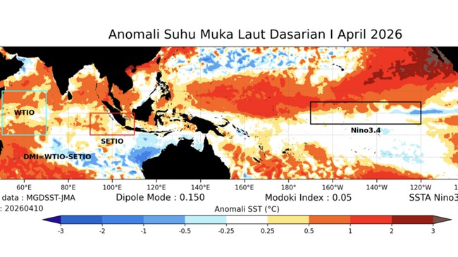
Super El Niño refers to a very strong El Niño event when sea surface temperatures in the central and eastern tropical Pacific rise significantly above normal.
Generally, El Niño is termed ‘super’ if sea surface temperature anomalies in the Niño 3.4 region reach around +2°C or higher for several months.
Impacts are particularly severe in agriculture. Increased risks of crop failure and livestock deaths could lead to commodity shortages and soaring food prices.
High uncertainty, but real risks remain.
While various weather models increasingly point to El Niño’s emergence, forecasters are not fully aligned on how strong the phenomenon will become.
AccuWeather forecasts the chance of a super El