Smoke Haze Blankets Pekanbaru, Visibility at Sultan Syarif Kasim II Airport Reduced to 1.2 Kilometres
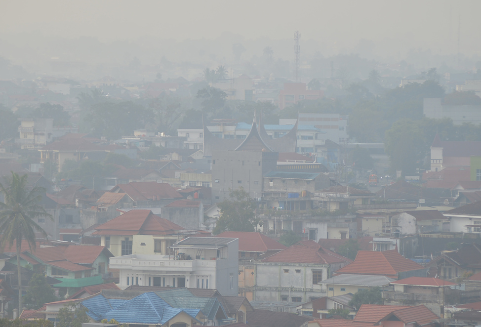
Smoke haze has been reported blanketing Pekanbaru City, Riau Province, on the morning of Wednesday, 11 March. The conditions have caused air quality to become irritating to the throat and reduced visibility at Sultan Syarif Kasim II Airport to approximately 1.2 kilometres, based on monitoring by the Indonesian Meteorology, Climatology, and Geophysics Agency (BMKG).
BMKG Pekanbaru forecaster Mari Frystine explained that weather conditions in the region were monitored as hazy to clear in the morning hours. BMKG observations indicated the occurrence of humid air turbidity phenomenon in Pekanbaru City.
“Weather enthusiasts, the low potential for rain today will cause land to dry out. Therefore, we advise you to dampen land in your yards to prevent dust, and do not conduct land clearing through burning as this can trigger forest and land fires,” she said in Pekanbaru on Wednesday, 11 March.
Meanwhile, BMKG also recorded 121 hotspots across Sumatra Island based on satellite monitoring until 23:00 Western Indonesia Time on Tuesday, 10 March. Of this total, Riau Province is the region with the highest number of hotspots, reaching 57 points scattered across various districts and cities.
In Riau Province, the highest concentration of hotspots was detected in Pelalawan Regency with a total of 15 points. This was followed by Bengkalis Regency with 11 points. Additionally, there were seven hotspots in Kampar Regency, four in Indragiri Hulu, three in Dumai City, three in Kuantan Singingi, two in Siak Regency, and one in Indragiri Hilir.
Reports from Manggala Agni of the Ministry of Forestry also mentioned forest and land fires in Pelalawan Regency, with teams deployed to the incident location. Meanwhile, the Regional Disaster Management Agency (BPBD) and the Riau Provincial Fire Department also reported forest and land fires in Bengkalis Regency.
Beyond Riau, several other provinces on Sumatra Island were also monitored for hotspots. Data showed Aceh recorded 19 hotspots, Jambi 14, Bangka Belitung 10, North Sumatra eight, South Sumatra six, Riau Islands five, and one each in West Sumatra and Lampung.
Forest and land fires in Sumatra and Kalimantan have caused the air quality standard pollution index (ISPU) to reach unhealthy levels due to thick smoke haze. Smoke from forest and land fires in Rokan Hulu Regency, Riau, has worsened. Peatland fires near SMK Maarif NU Martapura in Banjar Regency on Friday, 11 October, caused three students to faint and suffer shortness of breath from exposure to smoke haze.
Forest and land fires continue to occur in South Kalimantan Province. To date, operations at Syamsudin Noor Airport in Banjarbaru remain safe from smoke haze due to forest and land fires. The extent of forest and land fires in Riau during the January-February 2026 period reached 4,400 hectares, with 94 per cent of these located on peatlands (4,173.82 hectares).
The Ministry of Forestry, together with a joint team, has successfully controlled forest and land fires in Riau. The Indonesian Air Force and the National Disaster Management Authority (BNPB) continue to intensify weather modification operations to combat forest and land fires in Riau. Efforts to extinguish forest and land fires in Riau Province continue to be carried out intensively. Of eight forest and land fire locations in Riau, Pelalawan Regency is the region considerably affected.