Satellite Hotspot Detection Reveals Potential for Forest and Land Fires
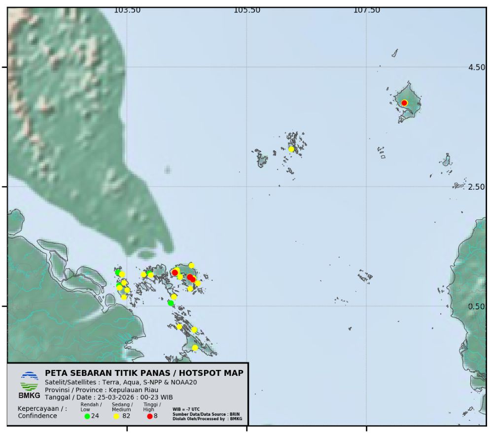
Monitoring of hotspots using VIIRS and MODIS sensors on polar satellites such as NOAA-20, S-NPP, TERRA, and AQUA continues to be one of the primary methods for detecting potential forest and land fires in various regions, including the Riau Islands. This technology provides an initial overview of locations experiencing significant temperature increases compared to surrounding areas.
Through remote sensing systems, satellites can detect thermal anomalies that are then identified as hotspots. This data serves as an early indicator of burning activities or forest and land fires. Monitoring is conducted routinely, both during the day and at night, allowing for broader and more continuous observation coverage.
The advantage of using VIIRS and MODIS sensors is their ability to monitor hard-to-reach areas. With support from several satellites operating in rotation, hotspot information can be updated periodically and utilised by various parties for disaster mitigation purposes.
However, this method also has limitations. Areas covered by thick clouds or in blank zones cannot be optimally detected by satellites. This can result in undetected hotspots, necessitating direct field verification to confirm actual conditions.
Suratman from BMKG at Hang Nadim Airport in Batam explained that satellite hotspot data is vital as an initial step in handling forest and land fires. “VIIRS and MODIS satellite hotspot data is very helpful in early detection of potential forest and land fires. However, its accuracy is still influenced by weather conditions, especially if areas are covered by clouds, so not all hotspots can be monitored,” he stated on Thursday (26/3).
He added that the obtained hotspot information is then coordinated with relevant agencies, such as local governments and disaster response teams, for direct field checks. This step is important to ensure whether the hotspot is indeed a fire or merely another heat source.
With satellite technology support, it is hoped that the early detection process for forest and land fires can be carried out more quickly and accurately. This is an important part of efforts to prevent the spread of fires, especially during the dry season when land and forest fire risks are high.
BMKG also urges the public not to conduct arbitrary land burning, considering its broad impacts on the environment, health, and transportation activities, particularly aviation in the Batam and surrounding areas. (H-2)
According to BMKG, the weather in the Riau Islands is currently dominated by thick clouds due to fairly strong wind speeds around the Kepri region and relatively low air humidity.
The warning was issued by Forecaster at BMKG Class I Hang Nadim Meteorological Station in Batam, Anisa S, based on tide analysis data.
Extreme hot weather sweeping Pekanbaru City is blamed as the main trigger for increasing fire vulnerability in peatland and scrub areas.
BMKG detected 113 hotspots in Riau as of 18 March 2026. Bengkalis and Dumai dominate. See updates on fire extinguishing efforts by the joint BPBD team here.
The Ministry of Forestry (Kemenhut) continues to strengthen efforts to control forest and land fires (karhutla).
Forest and land fire (karhutla) extinguishing squads from Manggala Agni continue to intensify extinguishing efforts at several fire points in Riau Province and Riau Islands Province.
The area of forest and land fires (karhutla) in Riau during the January-February 2026 period reached 4,400 hectares, with 94% of it in peatlands (4,173.82 ha).