Navigating Urban 'Rat Roads'
The phenomenon of using ‘rat roads’ is increasingly prevalent in several major cities in Indonesia. These alternative routes, consisting of narrow alleys to residential access points, have become the choice for drivers to avoid congestion on main roads, especially during rush hours.
The growth in the number of vehicles, which is disproportionate to road capacity, is cited as one of the main triggers. Based on the latest data from the Central Statistics Agency (BPS), the total number of vehicles in Indonesia is projected to reach around 172.9 million units in 2025, up from 166.5 million units the previous year. Motorcycles dominate with more than 139 million units in 2024. Since 2018 (106 million units), there has been an addition of around 26-30 million motorcycles over 6-7 years.
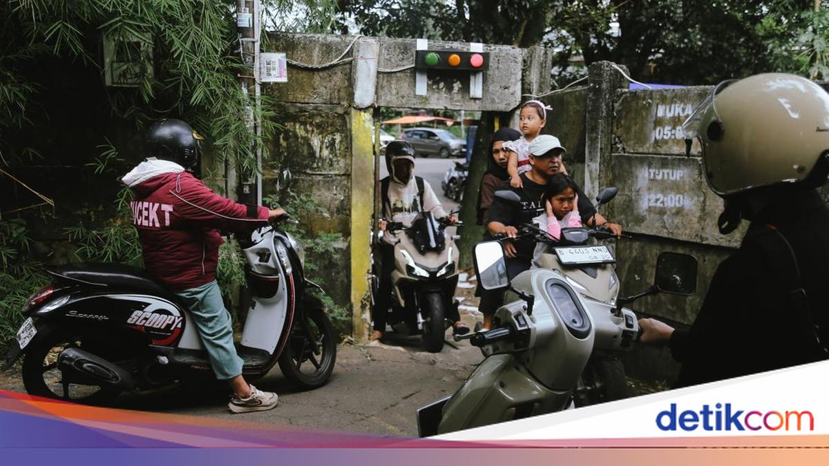
In South Tangerang, specifically Setu Subdistrict, there is a narrow route nicknamed the ‘Doraemon Gate’. This access is even equipped with a simple traffic light system to regulate vehicle flow to and from the Serpong area. Although only wide enough for one motorcycle, this route remains busy with drivers utilising it.
A similar situation occurs in Jakarta. Several drivers daringly cross the Tanah Kusir Cemetery area to avoid congestion in the Cipulir and Ulujami areas. Meanwhile, in Pasar Minggu, motorcycles crowd narrow roads at the border between South Jakarta and East Jakarta during rush hours.
Dense conditions are also visible around the Ciliwung River. At several points, such as hanging bridges connecting residential areas, drivers must share space with pedestrians. This practice creates a unique traffic dynamic but also carries high safety risks.
Not far from Pasar Minggu Station, specifically on Swadaya Dalam Street, East Pejaten, there is a narrow incline that serves as a connecting route to Poltangan Raya Street. At this location, local residents like Heri, Arifin, and Novan voluntarily regulate vehicle flow day and night to prevent congestion and potential accidents.
However, the use of rat roads is not without various problems. In addition to potentially causing conflicts between drivers and residents, the narrow road conditions not designed for dense traffic increase the risk of accidents.
In the end, rat roads are merely a temporary solution. Without drivers’ awareness to share space and without broader transportation system improvements, these alternative routes could instead become a source of new problems in urban life.
Motorcyclists cross an alternative road on Swadaya Dalam Street, East Pejaten, Pasar Minggu. Routes like alleys, small roads, and shortcuts are often chosen to avoid congestion on urban protocol roads.
This popular alternative road called ‘rat road’ is synonymous with narrow lanes in residential areas, even in some segments only wide enough for one motorcycle. For safety, convex mirrors are installed at corners leading to Lengkong Incline in Kampung Jawa, East Pejaten, Pasar Minggu, Jakarta.
In South Tangerang, Banten, there is a ‘rat road’ known as the Doraemon Gate. This route connects settlements in Setu Subdistrict with the Taman Tekno warehouse area, equipped with a red light system to maintain traffic order.
Traffic on urban alternative roads is often dense, especially during commuting hours. Around Pasar Minggu Station, motorcyclists and residents must share limited space on the route.
Online motorcycle taxi drivers crowd Jami’ Al-Makmur Mosque Street, Pasar Minggu. This ‘rat road’ location is near Pasar Minggu Station, making it busy with passersby.
Navigating ‘rat roads’ is not without risks. Drivers are required to be extra careful when crossing narrow alleys or ‘bumping alleys’, such as in Gang Haji Taip, Jakarta.
Many residents in Jakarta settlements feel uncomfortable because their environment has become increasingly noisy and crowded due to passing vehicle traffic. The comfort they once enjoyed is slowly being sacrificed for the common good.
The reflection of a motorcyclist is seen in front of a eatery in the Kramat Jati residential area, East Jakarta. The use of rat roads is not always free of obstacles; road limitations and high vehicle volume often trigger conflicts and increase safety risks, especially for surrounding residents.
In addition to crossing settlements, drivers also often take alternative routes through cemetery areas, such as in the Tanah Kusir area connecting Ulujami and Bintaro.
During rush hours, sharing space becomes unavoidable. Drivers and pedestrians must take turns crossing the Ciliwung River hanging bridge, creating a unique yet vulnerable traffic dynamic. This bridge also serves as the boundary between South Jakarta and East Jakarta.