Ministry of Forestry Engages Communities to Prevent Forest and Land Fires, Monitors Five-Year Cycle Risk
Jakarta — The Ministry of Forestry is strengthening prevention of forest and land fires (karhutla) by engaging communities in high-risk areas. This approach is being undertaken amid warnings of potential El Niño conditions in mid-2026 and a recurring cycle of major forest fires that typically occur every five years.
Kurniawati Negara, Head of Region I Section at the Forest Fire Control Centre (Dalkarhut) Jabalnusra Region under the Ministry of Forestry, stated that community engagement is being carried out through the establishment and development of Fire Care Community Groups (MPA) at village level.
“MPA will conduct initial fire suppression if a fire occurs as first aid. They have been equipped with knowledge and equipment, whilst coordinating with the dalkarhut centre,” Kurniawati told Republika on Thursday (12 March 2026).
According to Kurniawati, the community-based approach is important because most forest and land fires are triggered by human activity. She noted that nearly all karhutla cases in Indonesia are linked to human factors.
The Dalkarhut Centre regularly provides training to MPA groups in various high-risk areas. Training efforts focus on villages that experienced fires in the previous year.
In addition to community training, prevention activities are conducted through area patrols, installation of warning signs prohibiting land burning, and campaigns in schools located near forest areas.
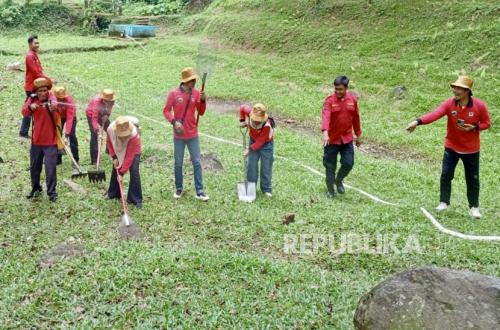
The Dalkarhut Centre also conducts fire suppression simulations involving various parties, including Manggala Agni and MPA groups. These simulations aim to maintain personnel readiness and ensure firefighting equipment remains operational in the field.
During a simulation held in Kuningan Regency in late February, communities participated to enable them to conduct initial response procedures should fires occur at ground level.
The Dalkarhut Jabalnusra Centre recorded that forest and land fire coverage in Region I Section, covering Banten, Jakarta, and West Java, reached approximately 35,770.03 hectares across the 2018–2025 period.
In West Java, several districts recorded the largest fire coverage during this period. Majalengka Regency became the area with the highest fire indication at approximately 9,028.93 hectares, followed by Indramayu at 8,159.16 hectares and Subang at approximately 3,970.94 hectares.
Other areas with significant incidents include Sukabumi at approximately 3,225.14 hectares, Sumedang at 3,023.57 hectares, Cirebon at 3,005.82 hectares, Garut at 2,151.99 hectares, Kuningan at 2,015.19 hectares, and Bandung at approximately 638.61 hectares.
The data also shows fluctuations in fire coverage year on year. In 2018, approximately 4,103 hectares were recorded, increasing to 9,554 hectares in 2019, then declining to approximately 2,343 hectares in 2020 and 1,299 hectares in 2021.
Fire coverage increased again in 2022 to approximately 2,005 hectares, reaching its peak in 2023 at approximately 11,524.8 hectares, before declining to 4,548.58 hectares in 2024 and 1,610.65 hectares in 2025.
The Ministry of Forestry is also monitoring the potential for increased karhutla this year amid predictions from the Meteorological, Climatological and Geophysical Agency regarding the possible emergence of El Niño phenomena in mid-2026.
This phenomenon has the potential to trigger prolonged dry seasons and increase forest fire risk, particularly in areas with high vulnerability levels.
In addition, large-scale karhutla incidents also frequently follow an approximately five-year cycle. The previous major peak occurred in 2019, making 2026 a period that requires heightened vigilance.
Therefore, the government is strengthening prevention measures from the outset through integrated patrols, hotspot monitoring, and community empowerment in fire-prone villages.