Megathrust in Indonesia Waiting for Time to Strike: Pay Attention to 14 New Red Zones
Indonesia is facing increased earthquake risk as the number of megathrust zones identified in the 2024 Indonesian Earthquake Source and Hazard Map has risen. The latest map records 14 megathrust zones, an increase of one compared to the 2017 edition which contained only 13 zones.
Iswandi Imran, a member of the Indonesian Academy of Sciences (AIPI) and professor at Bandung Institute of Technology (ITB), highlighted significant changes in the updated map. According to him, the tighter hazard contours on the 2024 map indicate an increase in earthquake risk in several regions across Indonesia.
“When we compare the 2017 and 2024 maps, the tighter contours on the 2024 version indicate an increase in earthquake hazard in certain areas of Indonesia,” Iswandi stated on Sunday, 1 March 2026.
The 2024 map also notes the potential for very large earthquakes in several zones. The Java Megathrust Zone, for example, has potential for earthquakes up to a maximum magnitude of 9.1. Meanwhile, several other zones such as Enggano and Mentawai-Pagai have the potential to trigger earthquakes up to 8.9.
The 14 megathrust zones in the 2024 Indonesian Earthquake Source and Hazard Map and their maximum magnitude potentials are:
Aceh-Andaman (magnitude 9.2)
Nias-Simeulue (8.7)
Batu (7.8)
Mentawai-Siberut (8.9)
Mentawai-Pagai (8.9)
Enggano (8.9)
Java (9.1)
West Java (8.9)
East Java (8.9)
Sumba (8.9)
North Sulawesi (8.5)
Cotobato Trench (8.3)
Southern Philippines (8.2)
Central Philippines (8.1)
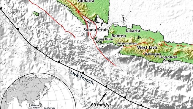
Previously, the Indonesia Meteorology, Climatology and Geophysics Agency (BMKG) identified two megathrust zones that are currently “waiting for time” to release their energy: the Sunda Strait Megathrust, which last experienced an earthquake in 1757, and Mentawai-Siberut, which last experienced one in 1797.
The BMKG explained that this condition is known as a seismic gap, a region that geologically holds large amounts of energy because it has not experienced a major earthquake for an extended period.
“Waiting for time is not a prediction. This phrase is often misunderstood. What it means is that the zone holds significant potential because it has not released energy for a long time. It does not mean an earthquake will occur in the near future,” the BMKG stated through its official Instagram account.
The BMKG emphasised that the term is used as a form of vigilance based on historical and geological data, not to trigger public panic.
“This scientific term is used as a form of vigilance based on historical and geological data, not to cause panic. Under Law No. 31/2009, the BMKG is responsible for observation, data management, and information services, including earthquakes and tsunamis,” the BMKG explained.