Manggala Agni Quells 50 Hectares of Forest and Land Fires in Riau
A team of forest and land fire extinguishing units, Manggala Agni of the Ministry of Environment and Forestry (Kemenhut), together with several other parties, is controlling fires in Bengkalis and Pelalawan regencies in Riau Province. The area burned across the two districts is estimated to be tens of hectares.
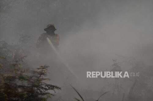
Head of the Sumatra Fire Control Centre Ferdian Krisnanto said the team is currently cooling down at the fire sites to ensure there is no remaining flame that could trigger a fresh outbreak.
‘The potential for smoke remains high, so mopping up—extinguishing remaining pockets of fire and cooling down—is still being undertaken,’ Ferdian said in a statement on Thursday (5 March 2026).
Ferdian explained that the forest and land fire occurred in a limited production forest area in Sukarjo Mesin Village, Rupat District, Bengkalis Regency. The area burned in that locality was estimated at around 50 hectares.
‘We will complete the operation until there is no potential, however small, for it to spread or flare up again because the fire is peat,’ Ferdian said.
The suppression was conducted with several parties, including the police, the Indonesian National Armed Forces (TNI), the Regional Disaster Management Agency, Masyarakat Peduli Api, and the local government.
Meanwhile, there were also fires on land used for other purposes in Gambut Mutiara Village, Teluk Meranti District, Pelalawan Regency. The affected area there was around 68.3 hectares. ‘The team, together with MPA and PT TH Indo Plantation, ensured that the firefighting was truly completed,’ Ferdian said.
Ferdian emphasised that Manggala Agni would continue firefighting efforts while strengthening prevention measures. Approaches include early detection, preventive patrols, monitoring of field conditions, and social engagement with communities.
From January to early March 2026, Manggala Agni in Sumatra has conducted preventive patrols against forest and land fires in 80 villages across North Sumatra, Riau, the Riau Islands, Jambi, and South Sumatra.
‘Patrols are conducted not only for security but also as a means of engaging with the community so that people understand more about the dangers and impacts of forest and land fires. Community involvement is the key to prevention success,’ Ferdian said.
In addition to ground efforts, the government is also conducting Weather Modification Operations (OMC) to accelerate rainfall in areas prone to fires. The operation was conducted by the National Disaster Management Agency as a response to requests from the Riau Provincial Government and recommendations from the Meteorology, Climatology, and Geophysics Agency, as well as the Ministry of Environment and Forestry.
Ferdian explained that the operation focused on Pelalawan, Bengkalis, Siak, and Dumai to help moisten peatland and maintain soil moisture.
Data from the Meteorology, Climatology, and Geophysics Agency show that the dryness level of surface fuel in several parts of Riau remains within a dry category for the next several days, keeping vigilance against the potential for fires.
Separately, NASA satellites via the NOAA-20 sensor detected a number of hotspots on Thursday dawn (5 March 2026) in several parts of Sumatra. Hotspots were observed in Rokan Hulu Regency, Riau; Muara Enim, South Sumatra; and several areas in Jambi Province.
NASA MODIS sensors also detected hotspots in Indragiri Hilir Regency, Riau. The data indicate that hotspot activity continues to appear in several areas across Sumatra within a closely related time frame.