Kudus BPBD Tackles Eight Landslide Sites and Reopens Road Access for Residents
Kudus, Central Java – The Kudus Regency Disaster Management Agency (BPBD Kudus), together with a joint team, is working hard to handle a landslide disaster that occurred at eight locations across three villages, and the road access previously blocked by landslide material has been passable again.
The eight landslide locations are three sites in Rahtawu Village (Gebog District), four sites in Menawan Village (Gebog District), and one point in Soco Village (Dawe District), said Kalakhar BPBD Kudus Eko Hari Jatmiko in Kudus on Sunday.
He said the landslide events at eight locations occurred on the same day, Saturday (7 March) night after heavy rainfall.
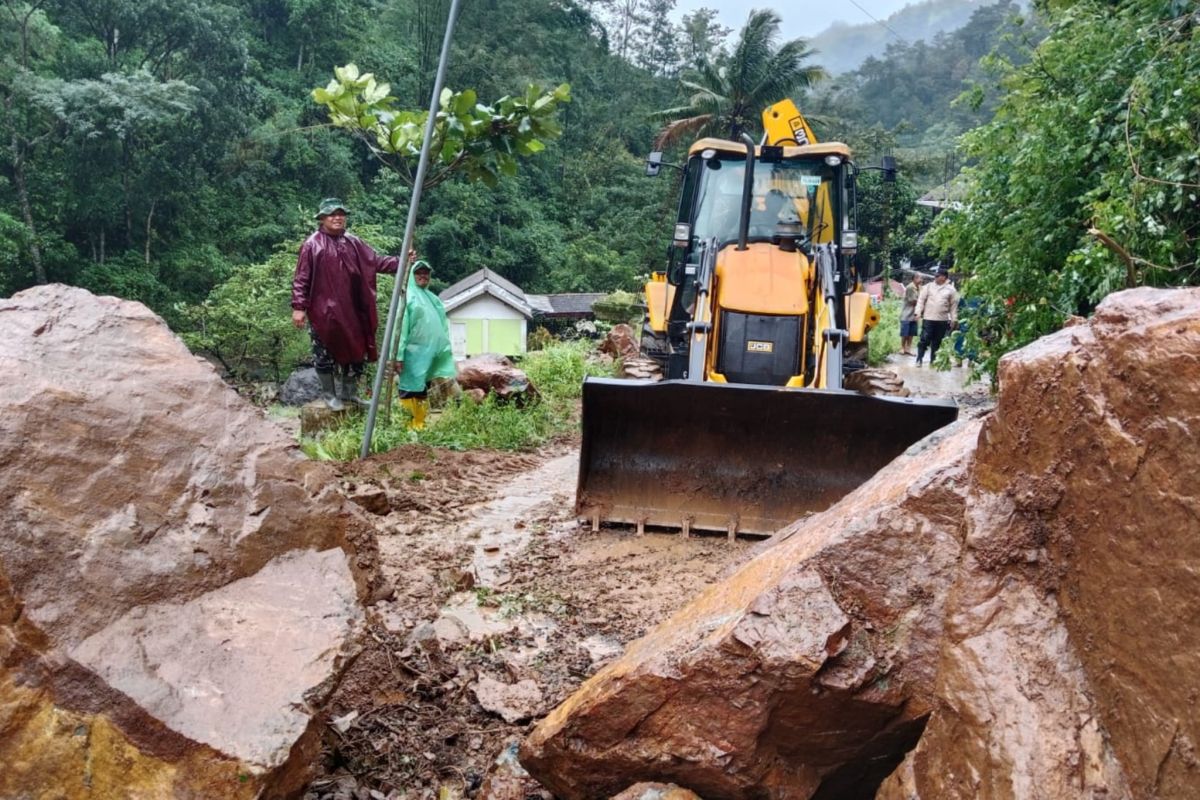
Meanwhile, the location of the landslide that blocked road access was in Dukuh Semliro, Rahtawu Village, where in addition to soil there were also large rocks.
With support from many parties, including BPBD, volunteers, Destana, Kencana, TNI/Polri, and the community, road access could be traversed by vehicles again, after a mutual cleaning of the road toward Dukuh Semliro was completed around 12:45 WIB.
He urged residents to remain alert and vigilant during heavy rainfall. If there is heavy rain, stay alert or move to a neighbour’s house that is safe and not prone to landslides, likewise residents travelling to Rahtawu or Menawan should be careful watching the weather because when heavy rain and strong winds coincide, it is best to stop in a safe place.
Gebog Sub-district Head Fariq Musthofa confirmed landslide events in his area, including in Rahtawu Village which caused road access for residents to be closed by landslide material including earth and rocks after a landslide on Saturday (7/3) at 21:00 WIB.
“To promptly open the sole road access, the elements of the Gebog District Leadership Coordination Forum (Forkopimcam Gebog) together with the village government, volunteers, and local residents carried out a communal work to clear the road from landslide material that closed the road,” he said.
He disclosed the various groups involved, including Destana, Banser, and Rahtawu villagers. The work-cleaning targeted clearing the road of landslide material including large rocks that blocked the village road using improvised tools and with the help of one excavator from the Public Works and Spatial Planning Service (PUPR).
Additionally, he said, officers also created a temporary drainage channel, repaired the former landslide, and cleaned the water flow and piles of material along the village road.
The Gebog Forkopimcam continued monitoring at several high-risk landslide points in Rahtawu to anticipate any aftershocks. Meanwhile, the village government along with Babinsa, Bhabinkamtibmas, and village apparatus urged residents to stay vigilant, especially during heavy rainfall. Residents were also asked not to travel unless there is an urgent need to avoid the risk of subsequent disasters.
“We are also enhancing coordination and synergy between the village government, Forkopimcam Gebog, Destana, volunteers, and the community to ensure rapid and precise disaster response,” he said.
Based on the disaster-prone map, Kudus Regency has 13 villages with the potential for landslides, namely Rahtawu, Menawan, Jurang, and Kedungsari in Gebog District; Terban in Jekulo District; and Soco, Ternadi, Japan, Kuwukan, Puyoh, Colo, Dukuh Waringin, and Cranggang.