Iran's Mountains and Deserts: A Natural War Shield Difficult for Enemies to Penetrate
Iran’s Strategic Position in Geopolitics
Iran’s strategic position in Middle Eastern conflict cannot be separated from the country’s own geography. Iran’s geographic conditions are often cited as one of the primary factors that make the nation difficult to conquer through ground invasion. The combination of high mountains, vast deserts, and complex terrain creates significant challenges for any military power attempting to enter its territory.
Geography Shaping Defence Doctrine
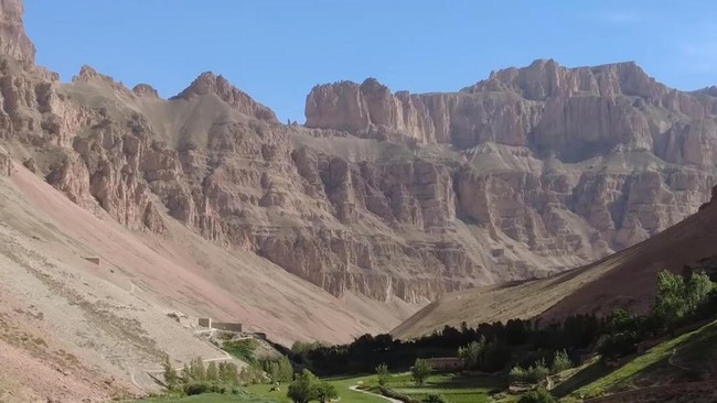
Iran’s territory stands on an extensive plateau known as the Iranian Plateau, a region with harsh landscape dominated by major mountain ranges such as Zagros in the west and Elburz in the north. Many mountain peaks in Iran tower between 3,000-4,000 metres, with narrow valleys and extremely limited access routes. This geographic condition makes the movement of large troop formations, tanks, and military logistics chains far more difficult, whilst slowing any ground invasion effort.
This natural structure forms a protective layer for the nation. For Iranian military, the topography functions as a force multiplier because it complicates every ground invasion plan by foreign powers. This terrain results in serious logistical difficulties for opponents wishing to enter Iran through conventional ground operations. High mountains, expansive deserts, fertile valleys, and open plains form a natural defence system. This combination makes large troop movements slow and easily detectable. Because of this, Iranian defence strategy for several decades has consistently relied on exploiting the depth of its geographic territory.
Beyond mountains, central Iran is also dominated by vast deserts such as Dasht-e Kavir and Dasht-e Lut. These areas are known for extreme temperatures, sandstorms, and severely limited water sources. Such conditions make ground military operations high-risk, particularly for troops required to carry large quantities of logistics. The combination of mountains, narrow valleys, and vast deserts means attacking forces can only move through limited routes. This situation facilitates monitoring whilst opening opportunities for ambushes. Consequently, large troop movements and logistics supply chains become slower and vulnerable to attack.
Military Facilities Dispersed Across Mountains
Iran’s territorial scale provides space for the government to disperse military facilities and strategic infrastructure across various locations. Nuclear infrastructure and ballistic missile programmes are placed at various distant points, often located in mountainous areas. When the United States launched air strikes in June 2025 through Operation Rising Lion and Operation Midnight Hammer, Iranian officials stated these facilities were not completely destroyed. The dispersed locations and positions embedded within mountain structures made destruction through air strikes alone difficult.
Iranian military doctrine has evolved in line with such geographic conditions. The Islamic Revolutionary Guards Corps (IRGC) has developed the Anti-Access/Area-Denial (A2/AD) concept, an approach aimed at preventing opponents from entering strategic territories. This pattern exploits the nation’s topography and surrounding sea routes. This strategy allows Iran to pressure regional enemies through precision strikes and use of proxy networks, whilst keeping conflict below the threshold of full-scale war.
High-Technology Attacks Begin Breaching the Fortress
This geographic advantage is being tested in the latest conflict. Joint operations by the United States and Israel launched on 28 February through Operation Epic Fury and Operation Roaring Lion brought attack technology capable of reaching targets deep within Iranian territory. Long-range stealth aircraft such as B-2 bombers were used to penetrate defence systems previously relying on natural protection. Israel also used the Black Sparrow air-to-surface ballistic missile designed to strike underground facilities.
Analysis of these operations reported over 1,000 targets attacked within the first 24 hours. Targets included IRGC command centres, ballistic missile production facilities, Iran’s conventional naval forces, and reinforced nuclear infrastructure in remote regions.
The Strait of Hormuz: Global Energy Pressure Point
Conversely, Iran relies on its geographic position along the world’s most vital sea route. The country has a southern coastline of approximately 1,802 kilometres facing directly onto the Strait of Hormuz. This narrow passage connects the Persian Gulf with the Gulf of Oman and is one of the world’s busiest energy shipping routes. This geographic proximity gives Iran the ability to control the strait’s northern side.
To exploit this position, Tehran has developed a military concept called Smart Control. This system is built on three interconnected technology layers. The first layer comes from the Sayyad-3G long-range air defence system with a range of approximately 150 kilometres deployed on Iranian warships. This system forms a mobile air defence umbrella for Iran’s small naval fleet.
The second layer comes from the use of multi-function drones capable of identifying and attacking air and maritime targets. This technology allows monitoring of ship traffic whilst selecting specific targets without closing the entire shipping route. The third layer comes from a network of maritime missiles. Iran has positioned cruise missiles on land silos and offshore platforms. This deployment maintains strike capability even when some facilities are destroyed.
Electronic Warfare and Ship Navigation Disruption
In the ongoing conflict, Iran is executing this strategy through technological warfare. Maritime intelligence reports indicate more than 1,100 ships experienced navigation disruption since early March due to GPS spoofing techniques. Ship navigation systems have been affected by these interference methods designed to disrupt vessel navigation along critical sea routes.