Indonesia on Alert for Severe Drought! Boiling Heat Monster El Niño Heading to RI
Indonesia is forecasted to experience a hotter, drier, and longer dry season in 2026, with the potential for a strong El Niño climate anomaly.
Although the Meteorology, Climatology, and Geophysics Agency (BMKG) and the National Research and Innovation Agency (BRIN) hold slightly differing views on the strength of the El Niño that will affect Indonesia.
The BMKG’s Analysis of Atmospheric Dynamics for the First Decade of April 2026, released on Monday, 13 April 2026, reveals that currently, 7.8% of Indonesia’s territory, or around the Seasonal Zone (ZOM), is already experiencing the dry season.
The areas currently in the dry season include parts of Aceh, parts of North Sumatra, parts of Riau, parts of Riau Islands, parts of Banten, parts of West Java, parts of Bali, parts of West Nusa Tenggara, parts of East Nusa Tenggara, parts of Gorontalo, parts of Central Sulawesi, parts of South Sulawesi, parts of Southeast Sulawesi, parts of Maluku, and parts of Southwest Papua.
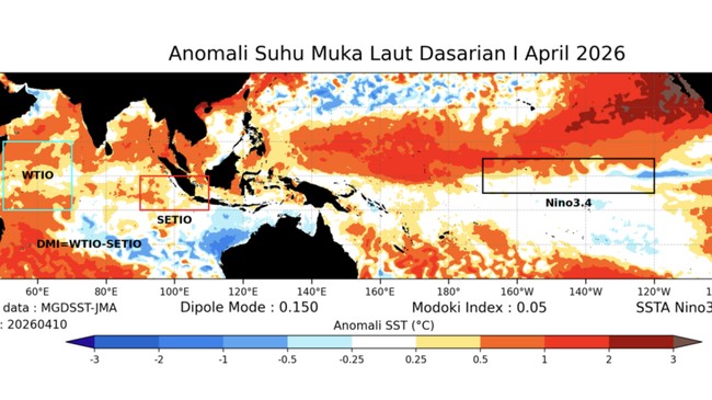
“The monitoring results for the First Decade of April 2026 show the decadal IOD index (monthly index) at +0.15 (+0.023), indicating that the IOD phenomenon is in a Neutral phase. Meanwhile, the decadal ENSO index (monthly ENSO) at +0.28 (-0.01) shows that the ENSO phenomenon is also in a Neutral phase,” BMKG stated, quoted from its official website on Tuesday (14/4/2026).
“The Neutral ENSO condition is predicted to enter the El Niño phase starting in May-June-July 2026,” BMKG added.
Reduced Rainfall
BMKG has issued an early warning for the potential meteorological drought event, applicable for the Second Decade of April 2026, as follows:
- Alert
Several districts in the provinces of Aceh, East Nusa Tenggara, and Central Sulawesi
- Standby
Several districts in the province of Aceh.
Rainfall in Indonesia for the period from the Second Decade of April to the First Decade of May 2026 is generally predicted to be in the low category, less than 50 mm/decade.
In the Coordination Meeting on Strategies for Mitigation and Handling the Impacts of the Long Dry Season in 2026, held at the Ministry of Public Works (PU) in Jakarta on Monday (13/4/2026), BMKG Head Teuku Faisal Fathani emphasised the importance of cross-sector preparedness in facing the 2026 dry season, which is forecasted to be drier and longer in duration compared to normal conditions.
“The current global climate condition is still in a neutral phase, with the ENSO (El Niño-Southern Oscillation) index around +0.28. However, in the second semester of 2026, this condition is expected to develop towards a weak to moderate El Niño phase with a 50-80% probability,” Faisal said.
“It should be understood that the dry season and El Niño are two different phenomena and do not always occur together. The dry season will still come every year in Indonesia. But if El Niño coincides with the dry season, then the dry season will become much drier,” he added by way of explanation.
Chance of Strong El Niño
Previously, Deputy for Climatology at BMKG Ardhasena Sopaheluwakan stated that according to BMKG predictions, the potential intensity of the El Niño that will hit Indonesia is in the weak to moderate category with a 50-80% chance.
And, he continued, BMKG notes a small possibility (less than 20%) that this phenomenon could develop into the strong category.
However, Ardhasena cautioned against over-interpreting the current prediction data. The reason is the spring predictability barrier phenomenon—a drastic drop in the accuracy of weather and climate model predictions for ENSO during the Northern Hemisphere’s spring period (March, April, May).
He explained that the accuracy of El Niño predictions generated during the March-April period is generally reliable only for forecasts up to three months ahead.
Therefore, he stressed, expertise is needed in understanding the multi-factor interactions that cause the emergence of El Niño conditions and their teleconnection impacts on Indonesian regions.
“For that reason, BMKG needs to continue monitoring data updates periodically and assessing their developments,” said Ardhasena.
“The confidence level regarding the intensity of El Niño will be higher in the May 2026 prediction results. Statistically, predictions in May have better reliability for covering climate conditions up to six months ahead,” he clarified.
Although the development of El Niño intensity is still being monitored, Ardhasena affirmed that the 2026 dry season will be drier.
“BMKG emphasises that the 2026 dry season is predicted to be drier and last longer than the normal average, also as a contribution from the natural climate variability in Indonesian regions,” said Ardhasena.
Godzilla El Niño Monster
Meanwhile, BRIN predicts that the intensity of El Niño this year will be very strong. It even names it as Godzilla El Niño and capable of triggering significant climate anomalies.
It is stated that this condition has the potential to make the dry season longer and drier, especially in western and southern Indonesia.
“El Niño is a phenomenon of warming sea surface temperatures in the equatorial Pacific Ocean. The El Niño phenomenon, including the potential for a strong ‘Godzilla’ variation, causes the dry season in Indonesia to become longer and drier,” wrote Researcher from the Centre for Climate and Atmospheric Research at BRIN Erma Yulihastin, quoted from the official Instagram post @brin_indonesia, cited on Tuesday (14/4/2026).
It is stated that several global models show El Niño beginning to develop since April 2026. At the same time, a positive Indian Ocean Dipole (IOD) phenomenon is also expected to occur and strengthen the drought impacts in Indonesia.
“Godzilla El Niño + Positive IOD, sounds cool, but the impacts are no joke. The dry season could become longer, drier, and rain falls less frequently in Indonesia. Clouds will mostly ‘hang out’ in the Pacific while we just get the heat,” BRIN wrote.
“Permission, this is not to scare you, KawanBRIN. But so that we can be more prepared from now on. Come on, start saving water, taking care of health, and being more aware of the conditions se