Giant Chasm Appears in Aceh Resembling a "Torn Earth" – What Does It Signify?
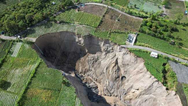
A giant chasm resembling “a torn earth” has emerged in Pondok Balek Village, Ketol District, Central Aceh, with reports indicating the fissure continues to widen and deepen. However, researchers have confirmed that the phenomenon is not a sinkhole, contrary to widespread public perception.
Adrin Tohari, head of the Geological Disaster Research Centre at the National Research and Innovation Agency (BRIN), explained that the event represents gradual slope failure resulting from local geological conditions. He noted that the area does not comprise limestone, the typical substrate responsible for sinkholes.
The area instead consists of pyroclastic flow deposits in the form of tufa material from the activity of Mount Geurendong, which is now inactive. This material is geologically young and has not undergone complete compaction, rendering it fragile and prone to collapse.
“What is occurring in Central Aceh is actually a landslide phenomenon, not a sinkhole. The tufa layers are not dense and possess low strength, making them easily eroded and collapsed,” Tohari stated.
Satellite imagery from Google Earth dating back to 2010 reveals that the area had already displayed a small valley or ravine. Over time, erosion and landslide processes have continued, causing the valley to widen and extend, ultimately forming the large chasm visible today.
Tohari added that seismic activity likely contributed to accelerating the process. A 6.2-magnitude earthquake in Central Aceh in 2013 may have weakened the slope structure, triggering increased instability.
Beyond geological factors and seismic activity, heavy rainfall serves as the primary trigger. The fragile tufa rock readily becomes saturated with water, losing its binding strength and subsequently collapsing. The steep slope gradient resulting from previous landslide processes has exacerbated conditions.
Tohari explained that surface water from plantation irrigation channels also contributes to landslide acceleration. Rapidly flowing water that seeps into the earth increases tufa layer moisture, escalating collapse risk.
“Should irrigation channels remain open and water continue to penetrate the soil, the already fragile layer becomes increasingly unstable,” he stated.
He also proposed a hypothesis regarding groundwater flow along the boundary between the denser lahar flow layer at the base and the fragile tufa above. Erosion at the slope’s foot by groundwater can cause the upper cliff section to lose support and collapse gradually.
The phenomenon does not occur suddenly but represents a process spanning decades to centuries. Earthquakes and rainfall merely accelerate the natural process of valley or ravine formation.
Tohari noted that similar conditions can be found in other regions with young volcanic rock geology. He cited Sianok Gorge in West Sumatra as an example, formed through extended geological processes related to the Sumatra Fault tectonic activity with comparable rock characteristics.
In this case, BRIN has not yet conducted direct field research at the location but has performed analysis based on satellite imagery.
“We are limited to analysing satellite data and public information. To determine the causes in detail requires comprehensive research,” he explained.
He suggested that further research could employ geophysical methods such as geoelectrical surveys, seismic reflection, and microtremor analysis to determine subsurface structure, potential fractures, and factors facilitating slope collapse.
Tohari also emphasised the importance of mitigation, particularly surface water management to prevent soil infiltration, hazard zone demarcation, and installation of early warning systems for landslides. He urged residents to remain vigilant for early indicators such as ground fissures or minor subsidence.
“Ground movement vulnerability maps already exist, but require updating following this event for greater accuracy and operational effectiveness. The priority now is understanding the process and promptly implementing mitigation measures to avoid loss of life,” he stated.
The Ministry of Energy and Mineral Resources’ Geological Agency characterised the phenomenon as piping erosion, not a sinkhole. In 2021, the agency had conducted an investigation at the site, concluding that several ground movement causes were present: rock that disintegrates when exposed to water, slope gradients that facilitate rock movement, and lateral erosion with drainage causing slope instability and water saturation.
Although the Geological Agency team continues further assessment to update data, preliminary analysis indicates the phenomenon represents piping erosion—subsurface or pipe erosion—rather than a sinkhole. The agency indicated that comprehensive analysis will follow once all processes are complete.
According to the analysis, the disaster area in Pondok Balek village falls within a low ground movement vulnerability zone, indicating low potential for ground movement. Such movement typically occurs in areas bordering river valleys, cliffs, road embankments, or disturbed slopes. Heavy rainfall and strong erosion can activate ground movement.