Complete Guide to Jakarta Floods: History, Causes and Permanent Solutions 2026
Indonesia suspends discussion on the Peace Council. Jakarta floods are not simply a seasonal weather phenomenon but an existential challenge for one of the world’s largest megacities. By 2026, flood mitigation efforts have evolved from mere emergency responses to mid-term strategies that are more structured through strategic projects.
Jakarta is built on a delta of 13 rivers that drain into Jakarta Bay. Since the Dutch colonial era, water problems have been a major issue. Some major flood records in Jakarta’s history include the years 1621, 1918, 1996, 2007, and 2020, which recorded the highest rainfall on record.
The flood phenomenon in the capital is triggered by the complex interaction between natural factors and human activity:
The DKI Jakarta Provincial Government has allocated around Rp2.62 trillion for mid-term flood control projects (2025-2027) which include a polder system, reservoirs, and normalisation of the main rivers.
Steps taken to minimise flood impacts in the future include:
The risk is real if land subsidence is not halted by stopping groundwater extraction and switching entirely to piped water.
These dams function as regulators of water discharge from upstream (Bogor) so that it does not flow simultaneously to Jakarta during heavy rainfall.
Residents can access the JAKI app or monitor the official BPBD DKI Jakarta social media accounts to obtain data on the latest flood points.
Disclaimer: This information is prepared based on historical data and strategic plans up to 2026. Field conditions can change according to weather dynamics and infrastructure progress.
Jakarta floods extended to 80 RT on 22 January 2026 due to extreme rainfall. See causes, updates on affected areas, and flooded road points here.
Why does Jakarta always flood? See an in-depth geological analysis on land subsidence, alluvial soil conditions, and the capital’s geographical challenges.
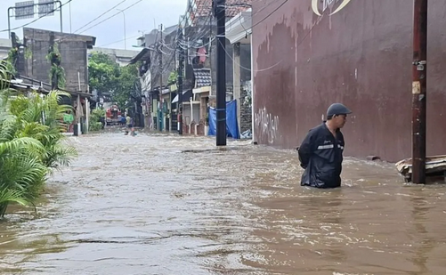
Flooding in Jakarta has always been a recurring problem and a major concern, especially when the rainy season arrives.
Yohan says there are 17 locations used by residents as evacuation sites, including the village hall, places of worship, and educational facilities.
Currently in the Jati Padang area, one RT is recorded as affected by floods with water heights reaching 80 centimetres.
Heavy rain from Saturday to Sunday (7–8/3) triggered floods in Jakarta. BPBD DKI records 147 RT and 19 road sections affected.
Flood updates in North Jakarta today, Saturday 31 January 2026. Marunda and Kapuk Muara inundated due to river overflow and heavy rainfall.
Jakarta Governor Pramono Anung has ordered an extension of weather modification operations from the previous end date of 23 January to 27 January.
Floods reaching 1.5 metres that submerged residential areas in Kebon Pala, Jatinegara, East Jakarta show no signs of receding.
A total of 125 RT and 14 road sections in DKI Jakarta were flooded on Friday (23/1/2026) morning due to extreme rainfall since Thursday night.