China Tracks US Military Movements in the Middle East, Iran Responds with Attacks
Beijing-based geospatial intelligence company MizarVision has been spying on US naval movements in the Middle East and circulating the images on social media as tensions with Iran flare. The Shanghai-based company posted satellite images showing US military activity, from carrier movements to the positions of fighter aircraft at various bases in the region. Some facilities and assets published by the company were subsequently targeted by Iranian missiles and drones, in the wake of the United States and Israel launching Operation Epic Fury on 28 February.
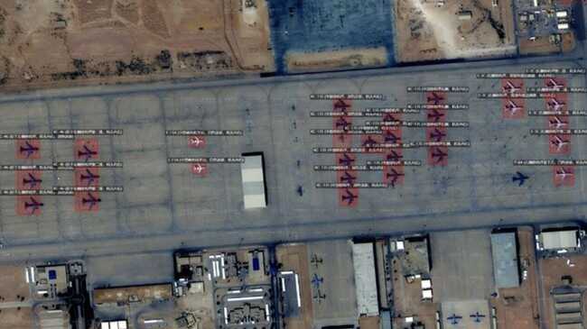
In posts on X, MizarVision showed key US military assets, including Lockheed Martin F-22 stealth fighters at Ovda Air Base in Israel, and several Boeing E-3 AWACS and Bombardier E-11 aircraft at Prince Sultan Air Base in Saudi Arabia.
“MizarVision said satellite imagery shows the US military continuing to move supplies to Ovda Air Base on Boeing C-17s,” as quoted by Flight Global on Friday, 6 March 2026. “During the same period, seven F-22s were parked on the ramp, and four F-22s were seen on the runway,” it added.
Besides air bases, MizarVision also tracked the movements of US aircraft carriers in the region. One example is the USS Gerald R Ford, the largest aircraft carrier in the US Navy, seen after leaving Souda Bay in Crete. The image posted on 26 February showed Boeing F/A-18E/F Super Hornets and Northrop Grumman E-2D early warning aircraft on the carrier deck. The company also published photographs of the carrier USS Abraham Lincoln in the Arabian Sea off Oman.
However, the source of the satellite images used by MizarVision remains debated. The China-based security think-tank South China Sea Strategic Situation Probing Initiative (SCSPI) stated that most images are likely from Western commercial satellites. “They are not Chinese satellite images. Based on the satellites’ ephemeris, it’s not hard to determine that most original images come from several American and European companies,” SCSPI wrote on X on 26 February.
Although formally a private company, MizarVision remains under the influence of the Xi Jinping administration and the policy of the ruling Communist Party of China. This suggests the firm could potentially obtain and release geospatial intelligence under Beijing’s direction.
Intriguingly, MizarVision’s X account shows the company joined the platform only in January and posted its first update on 24 February, as US troop movements in the Middle East were underway.
Unlike government-operated intelligence satellites, commercial reconnaissance satellite constellations do not carry the same risk of revealing sensitive details about the capabilities of a system or platform. The availability of commercial imagery also opens up new options for governments to use geospatial intelligence more flexibly.