BRIN Says Aceh Land Collapse Is Not a Sinkhole, Reveals Contributing Factors
Jakarta, VIVA – The Head of the Geological Disaster Research Centre at the National Research and Innovation Agency (BRIN), Adrin Tohari, has revealed the true cause of the ground subsidence or sinkhole event that occurred in Ketol, Central Aceh recently.
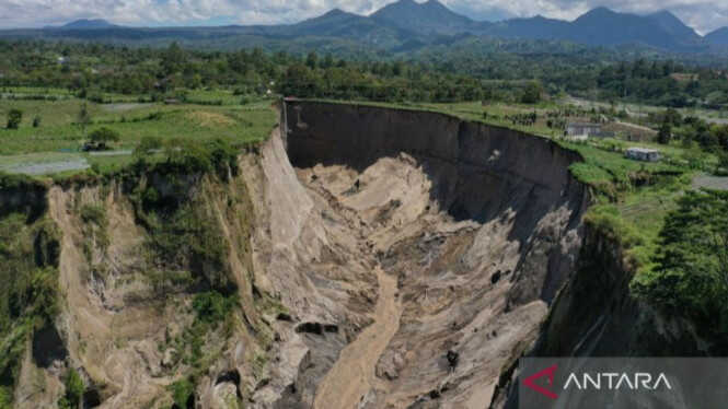
“What happened in Central Aceh is actually a landslide phenomenon, not a sinkhole. The tuff layer is not compact and has low strength, making it very susceptible to erosion and collapse,” he said in a statement in Jakarta on Saturday.
Adrin explained that Google Earth satellite imagery of the area dating back to 2010 had already shown the existence of a small valley or ravine. Over time, erosion and landslide processes continued, causing the valley to progressively widen and lengthen until it formed the large hole visible today.
He also suggested that earthquakes contributed to accelerating the process. The 6.2-magnitude earthquake that struck Central Aceh in 2013 likely weakened the slope structure, triggering increasingly severe instability.
Beyond geological and seismic factors, heavy rainfall served as the primary trigger. The fragile tuff rock easily becomes saturated with water, losing its cohesion and ultimately collapsing. The steep slope gradient resulting from previous landslides also exacerbated conditions.
Adrin explained that surface water from plantation irrigation channels also contributed to accelerating the landslides. Water flowing rapidly and seeping into the ground increased moisture levels in the tuff layer, thereby heightening the risk of collapse.
“If irrigation channels are open and water continues to enter the ground, then the already fragile layers become even more unstable,” he said.
Adrin also put forward a hypothesis regarding groundwater flow at the boundary between the denser lava flow layer at the base of the cliff and the fragile tuff rock above it. Erosion at the foot of the slope by groundwater can cause the upper portion of the cliff to lose its support and collapse gradually.
According to him, this phenomenon did not occur suddenly but rather represents a process spanning decades to hundreds of years. Earthquakes and rainfall merely accelerated the natural process of valley or ravine formation.
Adrin noted that similar conditions can be found in other regions with young volcanic rock geological characteristics. He cited Sianok Ravine in West Sumatra as an example, which was formed through a lengthy geological process related to tectonic activity along the Great Sumatran Fault with similar rock characteristics.