6 International Maritime Routes and Their Roles, from the Strait of Hormuz to the Strait of Malacca
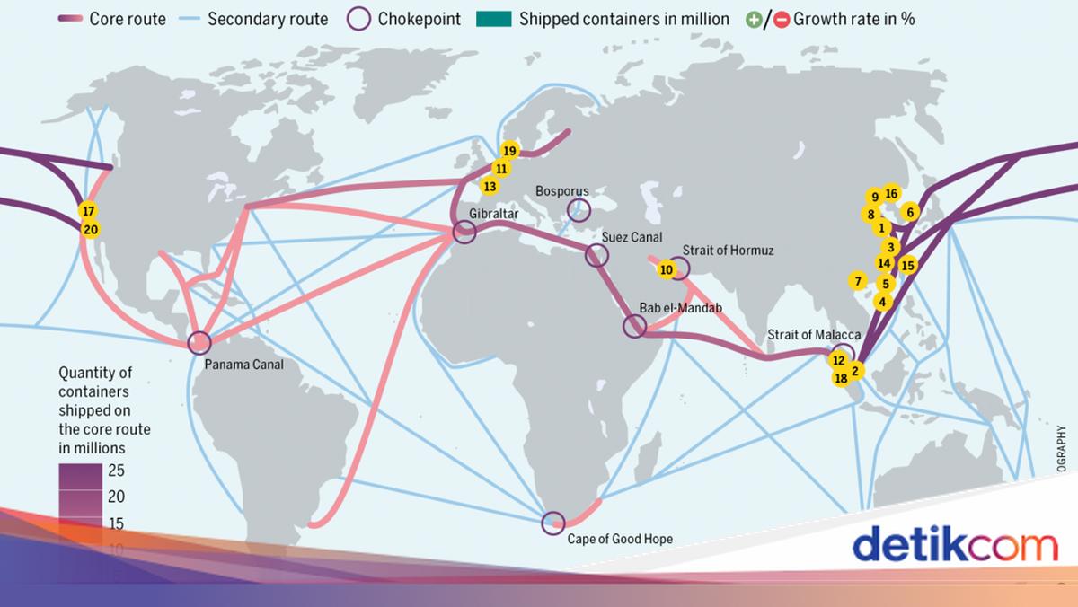
International maritime routes play a vital role in supporting the smooth flow of global trade. The majority of the world’s goods and energy distribution relies on sea routes connecting various continents. This makes sea transportation the main backbone of the international trade system.
It is no surprise that the existence of these strategic routes is a concern for many countries. This is because the stability and security of maritime routes greatly influence the global economic condition, especially in maintaining the smooth flow of logistics and energy distribution to various parts of the world.
In the book Supply Chain Management and Shipping Logistics by Ashury Djamaluddin, these routes are generally narrow straits or canals passed by a large number of ships every day. One of the most familiar is the Strait of Malacca, which is not only important globally but also holds strategic value for Indonesia as an archipelagic country.
Besides the Strait of Malacca, there are several other international maritime routes that are no less important in the global trade network. So, what are the six international maritime routes? Here is a complete review.
6 International Maritime Routes
To understand the strategic role of sea routes in global trade, it is important to recognise six international maritime routes. Referring to the same source, here are six international maritime routes that play a major role, including the Strait of Malacca located in the Indonesian region.
- Panama Canal
The Panama Canal is an artificial waterway approximately 82 kilometres long that connects the Atlantic Ocean and the Pacific Ocean by crossing the Isthmus of Panama. This canal is one of the most important maritime trade routes in the world because it significantly shortens the sailing distance for ships.
In its operation, a lock system is used to lift ships to Gatun Lake, an artificial lake about 26 metres above sea level. Gatun Lake itself was formed by damming the Chagres River and Alajuela Lake, aimed at reducing the need for canal excavation.
The existence of the Panama Canal has a major impact on global shipping efficiency. Ships no longer have to go around far through the southern tip of South America, such as passing through the Drake Passage or the Magellan Strait, which are known to be dangerous. This route is one of the greatest and most challenging engineering projects in human history.
Plans for the construction of this canal began to emerge in the 1500s, but it was only opened on 15 August 1914. Although its construction was plagued by various problems such as malaria, yellow fever, landslides, and water shortages, the canal has helped 800,000 ships cross since its opening, or 12,000 ships per year.
Along with the development of the times, the Panama Canal has also undergone expansion since 2007 to accommodate the size of modern ships that are getting larger. In its early days of operation, the canal’s size was already considered gigantic, but now large ships like tankers and aircraft carriers require more space.
- Suez Canal
The Suez Canal is one of the most important artificial maritime routes in the world that connects the Mediterranean Sea with the Red Sea through the Gulf of Suez. With a length of about 163 kilometres and a minimum width of 60 metres, this canal is the fastest route for modern ships sailing from the Atlantic Ocean to the Indian Ocean.
Unlike some other canals, the Suez Canal does not have a lock system. This is because the surfaces of the Mediterranean Sea and the Red Sea are relatively level. Thus, ships can pass directly without needing to be lifted or lowered.
The existence of this canal allows ships to save time and operational costs because they do not need to go around the African continent. In addition, this canal is also an important source of revenue for the Egyptian government through fees paid by ships passing through it every day.
The idea of building the Suez Canal actually emerged in the 19th century. The initial idea was pioneered by the French explorer Linant de Bellefonds, who surveyed the Suez Isthmus in the 1830s. After it was discovered that the two seas had almost the same elevation, the project was then promoted by Ferdinand de Lesseps, who succeeded in convincing the ruler of Egypt at that time to realise the canal construction.
The canal construction process began in 1859 and involved about 1.5 million workers over a decade. The work did not go smoothly due to various obstacles, such as disease outbreaks, political unrest, and limitations in construction technology that caused costs to swell dramatically. Despite the challenges, the Suez Canal was officially opened in 1869 and since then has become a vital route connecting trade between Europe, Asia, Africa, and Oceania.
- Strait of Malacca
The Strait of Malacca is one of the most strategic international maritime routes in the world, especially in Southeast Asia. This strait connects the Indian Ocean with the Pacific Ocean through the South China Sea. Moreover, its location between the island of Sumatra and the Malay Peninsula makes the Strait of Malacca a vital route passed by ships from various countries.
The important role of the Strait of Malacca is inseparable from the high shipping activity that crosses it. It is recorded that 400 ports and 700 ships rely on this route as the main passage for goods distribution, including fuel and industrial needs. Even many countries prioritise the security of the Strait of Malacca because the stability of this route greatly affects global trade and economy.
If traced back, the Strait of Malacca has been an international trade route since the early days of civilisation in the Nusantara. Traders from various regions, such as India and Tamil, have long utilised this strait for trading activities. This route also became an important connector