
Wildfires Spread: Four Mountains in East Java Ablaze, Five People Killed
Jakarta, CNBC Indonesia — The National Disaster Management Agency (BNPB) has reported that forest and land fires are spreading, with the fires now also reaching Java.
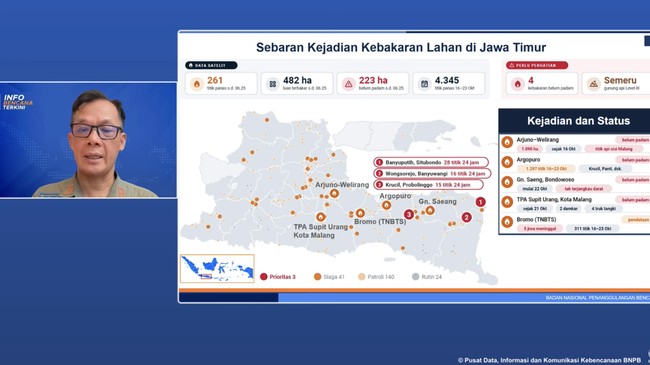
Berton Panjaitan, acting head of the BNPB’s Data, Information and Disaster Communications Centre, said fires had begun in East Java, affecting five districts: Malang, Magetan, Probolinggo, Situbondo and Banyuwangi.
“By Friday, 23 October 2026, there had been additional forest and land fires in East Java, in Malang, Magetan, Probolinggo, Situbondo and Banyuwangi,” Berton said at a press conference on the latest disaster situation in Indonesia on Friday (23 October 2026).
The BNPB recorded 261 hotspots in East Java, with 482 hectares of land affected and fires still burning across 223 hectares.
The agency also reported fires on four mountains in East Java.
“I can confirm that four mountains in East Java are currently on fire: Mount Arjuno-Welirang, Mount Argopuro, Mount Saeng and Mount Bromo,” Berton said.
The fires in East Java have claimed five lives. The victims were trying to put out a fire on Mount Bromo.
“Some time ago, we received information that five people had died while trying to extinguish the fire on Mount Bromo, but they became trapped in the area,” he said.
Meanwhile, efforts to tackle fires in the worst-affected areas of Kalimantan and South Sumatra are continuing.
Berton said Central Kalimantan remained the top priority because fires were still burning there.
“Three provinces in Kalimantan are critical areas that we need to bring under control. In Central Kalimantan, 16,097 hectares are currently being dealt with, the largest area. South Kalimantan has 1,506 hectares and West Kalimantan 1,370 hectares, bringing the total for the three provinces to 18,973 hectares,” he said.
In Sumatra, South Sumatra remained the worst affected, with 2,050 hectares burned, followed by Jambi with 379 hectares and Riau with two hectares.
“In Sumatra, 2,431 hectares have been burned so far. The largest area is in South Sumatra, at 2,050 hectares. Jambi has 339 hectares and Riau two hectares. These three provinces are a particular concern, especially South Sumatra,” he said.
The total number of forest and land fire incidents recorded in Indonesia between January and 23 October 2026 rose to 1,024.
Other disaster figures were broadly unchanged: 14 earthquakes, four volcanic eruptions, 581 floods, 337 extreme weather events, 122 droughts, 108 landslides and 14 tidal waves or coastal erosion events.
“Nationally, we have recorded 2,204 disasters across Indonesia from 1 January to 23 October. This figure continues to rise, and most are still dominated by hydrometeorological disasters, both wet and dry,” Berton concluded.