
Why the 1992 Flores Earthquake Was Deadlier Than 2026
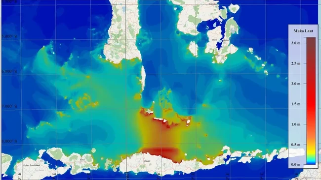
The Mw 7.7 earthquake that struck northern Flores, East Nusa Tenggara, on 15 August 2026, around 30 kilometres northeast of Mbay, Nagekeo, at a depth of about 15 kilometres, caused widespread damage and dozens of fatalities. A tsunami early warning was issued and later lifted after monitoring showed a relatively small tsunami.
The event immediately recalled the Flores earthquake of 12 December 1992. Its magnitude was almost the same, around Mw 7.7–7.8, but the accompanying tsunami was highly destructive. At Riangkroko, on the northeastern tip of Flores, a run-up of up to 26.2 metres was recorded and thousands of lives were lost, said Widjo Kongko, a researcher at the Hydrodynamics Technology Research Centre of the National Research and Innovation Agency (BRIN), in a written statement on Tuesday (24/8/2026).
According to Widjo, the two earthquakes had nearly identical magnitudes but produced very different tsunamis. The key lies not only in the size of the earthquake but in how the seafloor moves when a fault ruptures. A tsunami occurs when seafloor displacement disturbs the water column above it. Therefore, the source location, fault mechanism, direction and magnitude of slip, depth, and the shape of the seafloor and coastline all help determine the size of the tsunami.
Flores lies on the Flores Back-Arc Thrust system, an active tectonic zone resulting from the interaction of the Australian and Eurasian plates. The 1992 earthquake occurred very close to the coast and produced seafloor deformation that effectively generated a tsunami.
However, there is one interesting point. A tsunami model using only fault-induced deformation can explain many observations but cannot reproduce the extreme 26.2-metre run-up at Riangkroko. This is where the hypothesis of an earthquake-triggered submarine landslide becomes important. Previous research has indicated landslides at several locations and shown that the combination of tectonic deformation, landslides, and steep bathymetry can locally amplify a tsunami. Thus, the 26.2-metre figure at Riangkroko should not be regarded solely as a direct result of the earthquake magnitude.
What about 2026? Although the magnitude again reached Mw 7.7, initial modelling shows that the resulting tsunami was relatively small. The earthquake source modelling used a finite-fault model from the United States Geological Survey (USGS), which describes the earthquake source and fault plane in greater detail. Tsunami wave propagation was then modelled using the TUN3-BRIN model to see how the tsunami travelled from the source towards coastal areas. However, at several locations the observed tsunami height was still greater than the simulation results.
This difference is worth further investigation, especially once earthquake source data, bathymetry, and sea-level records become more complete. Care is needed when comparing the tsunami figures from the two events. The 26.2 metres in 1992 was a run-up measured on land, whereas the roughly 1.6 metres in 2026 was a tsunami height measured at a monitoring location. The two are not exactly the same quantity. Nevertheless, the difference still shows that the tsunami responses of the two events were indeed very different.
Widjo stressed that the most important lesson from Flores is not that the tsunami threat has diminished. On the contrary, the 2026 earthquake again showed that the Flores Back-Arc Thrust system remains active and capable of producing large earthquakes. The 1992 history also shows that a local tsunami can reach the coast within just a few minutes. In such conditions, coastal communities do not have much time to wait.
Therefore, after feeling a strong earthquake or prolonged shaking in a coastal area, the safest action is to move away from the shore immediately and head to higher ground without waiting for a siren. The 1992 and 2026 Flores earthquakes offer a simple but important lesson: nearly identical magnitudes do not mean the tsunami threat is the same. What matters is how the earthquake moves the seafloor, how the waves propagate, and how the coast responds. Understanding these processes is an important part of efforts to reduce disaster risk in East Nusa Tenggara.