
Why Kalimantan Suffers Severe Forest Fires, According to Researchers
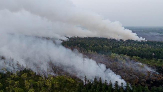
The Forest and Land Fire (Karhutla) disaster has struck South Kalimantan. Many videos circulating on social media show thick smoke blanketing the skies of Borneo. Meanwhile, CNBC Indonesia’s monitoring on Google Maps shows ‘Severe Fire’ status detected at many points in Kalimantan, with the densest points located in the South Kalimantan region. An estimated area of 572 square kilometres has burned, according to an update from Google satellite monitoring up to 3 hours ago. Meanwhile, the Head of the BNPB Data, Information and Disaster Communication Centre, Berton SP Panjaitan, said his party is still handling this disaster. ‘Until now, the karhutla task force, both air and land, continues to provide the best service to extinguish fires in several provinces affected by karhutla,’ he said via short message to CNBC Indonesia, Thursday (20/8/2026).
Looking at the historical record, severe karhutla in Indonesia has occurred several times, especially in the Kalimantan and Sumatra regions. Quoted from the official website of the Indonesian Young Geoscientists Forum (FGMI), the first largest forest fire was recorded in East Kalimantan in 1982. At that time, the El Nino phenomenon caused severe drought between June 1982 and May 1983. Apart from the prolonged dry season, shifting cultivation activities by burning new land for seasonal crop plantations such as rice, cassava, and corn were considered triggering factors for karhutla. There were also illegal logging activities that left behind waste accumulation overgrown with dense, flammable vegetation layers. The 1982-1983 fires were recorded to have burned 3.2 million hectares of land in East Kalimantan. The World Resources Institute (WRI) reported economic losses due to the forest fires reached US$9 billion.
Furthermore, there have been several other major karhutla incidents with similar causes. These include the 1997-1998 karhutla, 2006 karhutla, 2015 karhutla, and 2019 karhutla. These incidents not only caused economic losses but also damaged the environment, impacted global warming, and claimed lives.
Separately, in a study compiled by Annisa Musrifatun Nur’Aini and Athaya Putri Tatia Ananta from the Faculty of Forestry at UGM in 2025 and published in the BNPB disaster history literacy portal, it was revealed that karhutla is a recurring ecological disaster in Indonesia, especially in the Sumatra and Kalimantan regions. In fact, the impact of karhutla in Indonesia also extends to neighbouring countries such as Malaysia, Singapore, and Brunei. Researchers say karhutla in Indonesia has become a transboundary environmental issue requiring serious handling.
In the report, it is stated that the 2015 karhutla was one of the most severe in impact, with a burned area reaching 2.6 million hectares. This incident claimed dozens of lives and caused hundreds of thousands of respiratory illness cases. The researchers highlighted studies from various sources showing that most karhutla in Indonesia is triggered by human or anthropogenic activities.
The practice of land clearing by burning is still rampant in Indonesia. This method is considered the most cost-effective and fastest way for some corporations and small-scale farmers. However, this false efficiency actually brings systemic impacts that harm the economy. The risk of karhutla rises sharply when entering the dry season. Dried vegetation conditions make fires spread very quickly and difficult to control.
Vulnerability is further exacerbated by the draining of peatlands through canalisation. Peat ecosystems that have lost their moisture have the potential to trigger subsurface fires burning beneath the ground surface. This type of fire is very dangerous because it can persist for a long time and is difficult to extinguish.
Illegal logging activities and massive land conversion further worsen field conditions. The loss of forest vegetation cover disrupts the local microclimate, making the air in the ecosystem area much drier and prone to burning. On the other hand, extreme climate phenomena such as El Nino trigger delays in the rainy season and prolong the dry period. Although climate factors are not the main trigger, El Nino accelerates the severity and speeds up the spread of hotspots.
The impacts of the karhutla disaster reach various major sectors:
Environmental Aspect: Biodiversity extinction, deep ecosystem damage, and a surge in carbon emissions released into the atmosphere accelerating global climate change.
Health Aspect: Exposure to toxic haze pollution causes a surge in Acute Respiratory Infection (ISPA) cases and the risk of premature death in vulnerable groups.
Economic Aspect: Significant financial loss threats to the agricultural sector supply chain, forestry businesses, transport mobility disruptions, and the cessation of regional trade activities.
‘Karhutla control requires a long-term approach that does not only focus on extinguishing but also on improving the socio-economic aspects of communities around forests. Social forestry programmes, improving farmer welfare, providing alternatives to land clearing without burning, and strengthening land governance are important parts of sustainable prevention strategies,’ wrote the study from UGM researchers.
‘Lessons from the history of karhutla must continue to be integrated into development planning so that forest and land management in Indonesia can run sustainably and be free from haze disasters.’