
Why Indonesia Is Seeing Heavy Rain During a Very Strong El Niño: BMKG Explains
Jakarta, CNBC Indonesia – The Meteorology, Climatology and Geophysics Agency (BMKG) says several regions could experience heavy rain in the coming days, even though El Niño remains very strong.
BMKG said the current dry conditions have been intensified by the combined effects of a very strong El Niño and a positive Indian Ocean Dipole (IOD). From 26 to 28 October 2026, rainfall was scarce and cloud cover limited, while temperatures exceeded 37°C in areas including Lampung and Central Sulawesi.
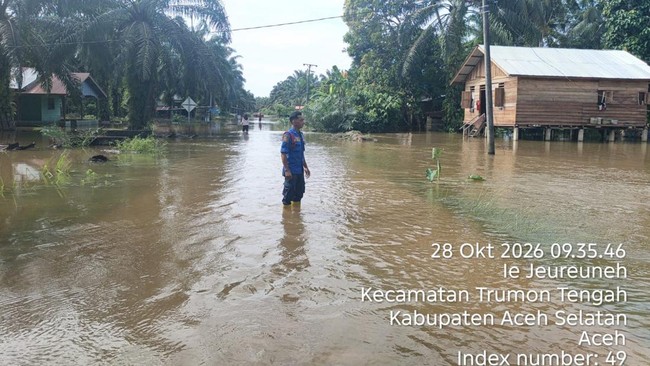
Despite the ongoing drought, extreme weather in the form of heavy rain is also forecast in other areas. Heavy to very heavy rainfall was recorded in North Sumatra, reaching 131.0 millimetres per day, West Sumatra at 97.0mm, Aceh at 75.0mm, West Kalimantan at 65.0mm and West Nusa Tenggara (NTB) at 55.0mm.
“Abundant water vapour resulting from warm sea-surface temperatures, combined with wind convergence and the active Madden-Julian Oscillation (MJO), Equatorial Kelvin waves, Equatorial Rossby waves and MRG, are the main factors triggering rain in these areas,” BMKG said in an official statement cited on Friday (30 October 2026).
For the first 10-day period of November 2026, BMKG forecasts that most of Indonesia will receive moderate precipitation of 50–100mm per 10-day period, accounting for 67.62% of the country. Low precipitation of 0–50mm is expected across 30.57% of the country, while high precipitation of 150–300mm is forecast in 1.81%.
Low precipitation is concentrated in Lampung, Banten, Jakarta, Java’s northern coast, East Java, Bali, the Nusa Tenggara islands, and parts of Sulawesi and Maluku.
Although 10-day rainfall totals are expected to be low to moderate, atmospheric conditions could still trigger the formation of convective clouds. Over the coming week, the MJO is forecast to affect western and southern Indonesia, while Kelvin waves are expected to be active in the east.
“These phenomena promote the growth of rain clouds, particularly in areas with converging air masses and significant atmospheric instability,” BMKG said.
Regional wind patterns are also being influenced by Tropical Cyclone Seed 91B over the Andaman Sea and a cyclonic circulation over the Natuna Sea.
The two systems are creating zones of convergence and slower winds, or confluence, encouraging convective cloud formation that can bring moderate to heavy rain accompanied by lightning and strong winds.
Therefore, even though 10-day rainfall totals are expected to be moderate, the possibility of extreme daily rainfall means that preparations to mitigate hydrometeorological disasters remain necessary.
Rainfall outlook for the coming week
BMKG forecasts that the rainy season will gradually begin in the remaining months of 2026, starting in November and continuing into December, with its peak expected from December 2026 to February 2027. Tropical Cyclone Seed 91B was observed forming over the Andaman Sea, north of Aceh, at 1am local time on Thursday (29 October 2026).
Over the following 24 hours, its indirect effects could bring moderate to heavy rain to Aceh and North Sumatra, as well as waves of 1.25–2.5 metres in the northern part of the Strait of Malacca.
For the three-day period from 29 to 31 October 2026, BMKG issued an early warning for extreme weather. Alert-level conditions (heavy to very heavy rain) are possible in Aceh, Lampung, Bengkulu, Riau, West Sumatra, South Sumatra and North Sumatra.
Advisory-level conditions (moderate to heavy rain) cover Sumatra, Kalimantan, Sulawesi, Java, Bali, Maluku, North Maluku, NTB, East Nusa Tenggara (NTT) and Papua.
30 October–1 November 2026
Moderate rain is possible in Jambi, Banten, Jakarta, West Java, Central Java, Yogyakarta, East Java, Bali, NTB, NTT, West Kalimantan, Central Kalimantan, East Kalimantan, North Kalimantan, North Sulawesi, Central Sulawesi, South Sulawesi, North Maluku, Maluku, Southwest Papua, Central Papua, Highland Papua, Papua and South Papua.
Heavy to very heavy rain is possible in Aceh, North Sumatra, West Sumatra, Riau, the Riau Islands, South Sumatra, the Bangka Belitung Islands, Bengkulu and Lampung.
Very heavy rain accompanied by strong winds is possible in Aceh and North Sumatra.
2–5 November 2026
Moderate rain is possible in Aceh, North Sumatra, Riau, the Riau Islands, Jambi, South Sumatra, the Bangka Belitung Islands, West Java, Central Java, Yogyakarta, East Java, Bali, West Kalimantan, Central Kalimantan, North Kalimantan, Gorontalo, South Sulawesi, North Maluku, West Papua, Highland Papua, Papua and South Papua.
Heavy to very heavy rain is possible in West Sumatra.
Very heavy rain accompanied by strong winds is possible in Banten and West Sumatra.
BMKG advice
Given the potential weather conditions, BMKG urged the public to prepare for hot weather and drier air as the dry season continues. It said sunscreen should be used to reduce direct exposure to sunlight.
“People are also advised to maintain adequate fluid intake, especially when working outdoors during the day, to avoid dehydration and fatigue,” BMKG added.
As dry conditions intensify, residents and local governments are advised to conserve water and remain alert to drought and forest and land-fire risks.
BMKG urged the public not to burn rubbish or clear land indiscriminately, particularly in fire-prone areas such as peatland, scrub and forests, and to report any signs of fire promptly.
Although dry-season conditions remain dominant, localised light to moderate rain is still possible, sometimes accompanied by lightning and strong winds.
“Residents and stakeholders should remain alert to possible flooding, landslides and lightning strikes,” BMKG said.
Source: jawawa.id (https://jawawa.id/newsitem/why-indonesia-is-seeing-heavy-rain-during-a-very-strong-el-nino-bmkg-explains-1793364705)
Originally published by CNBC Indonesia (https://www.cnbcindonesia.com/news/20261030172655-4-781028/penyebab-ri-hujan-lebat-saat-el-nino-sangat-kuat-ini-penjelasan-bmkg), translated from Indonesian