
Very Strong El Niño: Red Fire-Risk Warnings Cover Much of Indonesia
Jakarta, CNBC Indonesia — Indonesia’s Meteorology, Climatology and Geophysics Agency (BMKG) has issued its latest weather outlook for the week of 20–26 October 2026, forecasting the possibility of rain in several parts of the country.
Hot and dry weather is expected to continue across Indonesia in mid-October, amid a very strong El Niño and a positive Indian Ocean Dipole (IOD). These conditions are reducing cloud cover and limiting rainfall.
According to BMKG, this could increase daytime surface heating and accelerate the drying of vegetation, making forests and land more vulnerable to fire.
A Fine Fuel Moisture Code projection, which indicates how easily the upper layer of surface vegetation can catch fire, showed that on Wednesday, 21 October 2026, much of Sumatra, Kalimantan, Nusa Tenggara, Maluku and Papua was in the “very easily combustible” category, shown in red. Java, Sulawesi and Bali were almost entirely covered by the same red category.
BMKG recorded maximum temperatures of 38.5°C in West Java and 38°C in Lampung and Central Java on 17 October 2026. East Java also recorded a maximum of 38°C on 16 October.
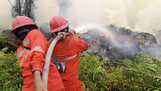
The agency noted an upward trend in hotspots between 16 and 19 October. On 19 October, the number of high-confidence hotspots in Central Kalimantan jumped from 157 to 937, while West Kalimantan’s rose from 31 to 231 and South Sumatra’s from 19 to 66 compared with the previous day. East Java also saw an increase, from 10 to 36 hotspots.
The increase in hotspots coincided with smoke detected across parts of Sumatra, Kalimantan, Sulawesi, Maluku and Papua. The developments underline the need for heightened vigilance against forest and land fires, particularly in Central and West Kalimantan.
Regional and local atmospheric conditions are nevertheless still conducive to rain-cloud formation in some areas. The Madden–Julian Oscillation (MJO), Equatorial Rossby waves, Kelvin waves and Mixed Rossby–Gravity (MRG) waves, together with slowing and converging winds and relatively warm sea-surface temperatures, are boosting convective activity, particularly in northern and western Sumatra and parts of Kalimantan. Heavy to very heavy rain was reported from 16 to 18 October, with rainfall reaching 105mm a day in Papua, 66mm in North Sumatra and 51mm in Central Kalimantan as a result of these atmospheric influences.
What can be expected over the coming week?
BMKG forecasts localised rain due to regional and local atmospheric dynamics.
For the third ten-day period of October through the second ten-day period of November 2026, most of Indonesia is expected to receive low to moderate rainfall, of 0–150mm per ten-day period.
“Relatively dry conditions may persist, particularly in parts of southern Sumatra, Java, Bali, Nusa Tenggara, Kalimantan, Sulawesi, Maluku and southern Papua. This is consistent with the development of El Niño and a positive Dipole Mode Index (DMI), which generally tend to reduce convective activity in Indonesia,” BMKG said on Tuesday, 20 October 2026.
BMKG early warnings
20–22 October 2026
Weather across Indonesia is expected to be mostly partly cloudy, with light rain.
Moderate rain is possible in West Sumatra, the Riau Islands, Bengkulu, Banten, West Java, West Kalimantan, East Kalimantan, North Kalimantan, Central Sulawesi, Southwest Papua, West Papua, Central Papua, Highland Papua, Papua and South Papua.
Heavy rain, potentially accompanied by lightning and strong winds, is forecast for the following areas:
Alert — heavy to very heavy rain: Aceh and North Sumatra.
Strong winds: South Sumatra, Lampung, Banten, West Java, Central Java, East Java, South Kalimantan, West Sulawesi, South Sulawesi, North Sulawesi, Papua and South Papua.
23–26 October 2026
Weather across Indonesia is expected to be mostly partly cloudy, with light rain.
Moderate rain is possible in North Sumatra, West Sumatra, Riau, Jambi, South Sumatra, the Bangka Belitung Islands, Bengkulu, West Kalimantan, North Kalimantan, Central Sulawesi, South Sulawesi, Central Papua and South Papua.
Heavy rain, potentially accompanied by lightning and strong winds, is forecast for the following areas:
Alert — heavy to very heavy rain: Aceh and Highland Papua.
Strong winds: Aceh, South Sumatra, Lampung, Banten, West Java, Central Java, the Special Region of Yogyakarta, East Java, South Kalimantan and South Sulawesi.
BMKG urged the public to prepare for the effects of hot weather and drier conditions as the dry season continues. It recommended using sunscreen to reduce direct exposure to sunlight and staying hydrated, particularly when spending time outdoors during the day, to avoid dehydration and exhaustion.
“Although the dry season remains dominant, localised light to moderate rain, potentially accompanied by lightning and strong winds, is still possible. The public and relevant stakeholders should therefore remain alert to possible flooding, landslides and lightning strikes,” BMKG said.
The agency also urged the public and local governments to conserve water and remain alert to the risk of drought and forest and land fires.
“BMKG asks the public not to burn rubbish or clear land indiscriminately, especially in fire-prone areas such as peatland, scrubland and forests, and to report any signs of fire immediately,” the agency said.