
Unej students design inclusive geospatial tool for visually impaired pupils
Many visually impaired pupils still struggle to learn geospatial concepts because teaching media are dominated by visual materials.
Jember, East Java (ANTARA) — Students of the Physics Education programme at the University of Jember (Unej) have designed an inclusive geospatial innovation for visually impaired pupils, aimed at delivering equal and inclusive access to education.
“Many visually impaired pupils still find it difficult to learn geospatial material because learning media are dominated by visuals. This issue matters because every child has the right to inclusive and equal access to education, as part of efforts to realise Golden Indonesia 2045,” said Santi Desi Safitri, a Physics Education student at Unej, at the campus on Monday.
According to her, equal and inclusive access to education still poses major challenges, particularly in fulfilling the learning rights of visually impaired pupils. One often-overlooked obstacle is geospatial learning material, or the understanding of the location of regions.
“To this day, the teaching of geography and spatial studies in schools is still dominated by static visual media such as conventional maps, which are almost impossible for people with visual disabilities to access independently,” she said.
Driven by deep concern over the urgency of this issue, Santi and two of her fellow students took concrete action with an innovative idea, realised in a multisensory technology design that breaks the deadlock of the learning space for children with special needs.
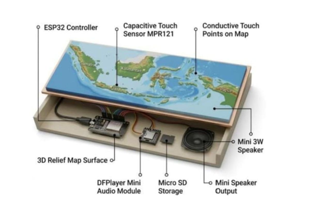
“The innovation integrates a raised relief map, touch sensors and interactive audio in a single system controlled by an ESP32 microcontroller,” she said.
She explained that the way the medium works is strongly oriented towards pupil independence: when a pupil touches a region on the raised map, the system plays audio information so they can understand the location and characteristics of the region through touch and hearing simultaneously.
“The multisensory approach championed by GEOTIVA not only improves accessibility of the material, but also helps visually impaired pupils build effective and meaningful spatial understanding,” she said.
Understanding spatial concepts is considered crucial because it trains their spatial orientation, mobility and independence in daily life.
Through this social sensitivity towards inclusive education, the Unej students hope to spark a wider movement among the younger generation to keep producing solutions with a direct impact on society.
“Don’t be afraid to try. Start from real problems in the community, carry out solid research, and develop innovative solutions that benefit society. Spirit and consistency are the keys to producing the best work,” she said.
The humanitarian and inclusive idea designed by the Unej Physics Education student team has also been tested for feasibility at national level, as the GEOTIVA innovation earned the students third place in the National Student Essay Competition INNECTION, organised by Syarif Hidayatullah State Islamic University (UIN) Jakarta some time ago.
The achievement serves as important validation that socially-conscious research from Unej’s green campus can offer real solutions for the future of inclusive education in Indonesia.