
Understanding the Cugenang Fault in Cianjur: Discovery, Path, and Earthquake Risks
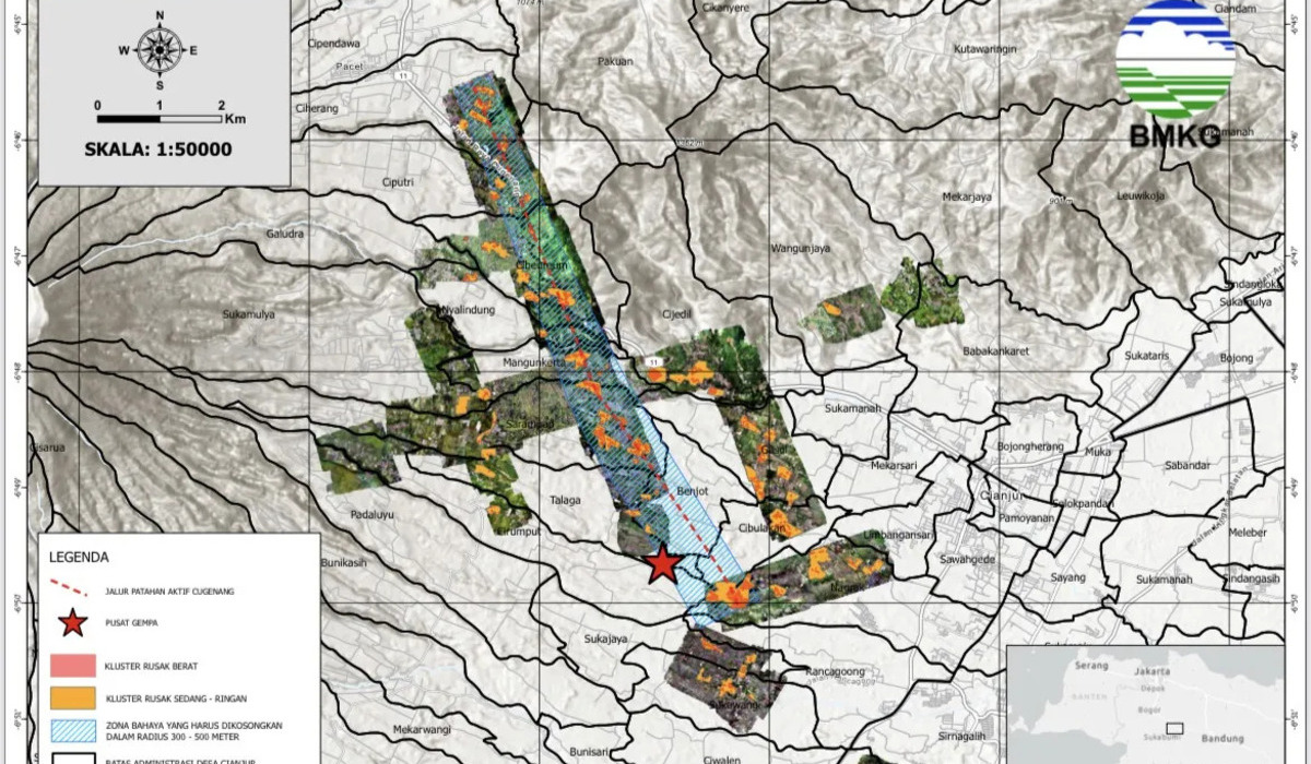
The earthquake that shook Cianjur Regency on 21 November 2022 not only left deep sorrow but also revealed a new geological feature in West Java. The Meteorology, Climatology, and Geophysics Agency (BMKG) has officially identified a new active fault that was the primary trigger of the disaster, which has subsequently been named the Cugenang Fault.
This discovery is crucial because the area was previously not recorded as having a specific active fault line at that precise location. The identification of the Cugenang Fault compels the government and the community to review spatial planning and disaster preparedness within this red zone.
The Cugenang Fault was discovered after BMKG technical teams conducted a comprehensive analysis following the magnitude 5.6 earthquake that hit Cianjur. Initially, this earthquake was suspected to have been triggered by activity from the Cimandiri Fault or the Nyalindung-Cibeber Fault. However, based on focal mechanism analysis and the distribution of aftershocks, a pattern was found that did not align with previously existing fault lines.
Through field surveys involving the mapping of surface ruptures, the distribution of building damage, and the use of precision monitoring technology, BMKG concluded that a new fault extends across the Cugenando District. This finding was officially announced at the end of 2022 as an effort to provide certainty regarding safe zones for building reconstruction.
Based on the released data, the Cugenang Fault possesses the following characteristics:
Villages identified as being directly traversed by this fault line include Ciherang, Ciputri, Cibeureum, Nyalindung, Mangunkerta, Sarampad, Talaga, and Nagrak.
The existence of the Cugenang Fault brings serious consequences for the safety of settlements situated above it. The following potential hazards must be monitored:
Areas located directly above the fault line (prohibited zones) face a high risk of extreme ground displacement and total building destruction if tectonic activity recurs.
Through BMKG and BNPB, the government has established ‘Prohibited Zones’ or red zones along the Cugenang Fault line. A recommended safe radius is approximately 200 to 500 metres from the fault axis. In these zones, the public is prohibited from rebuilding permanent residences.
Land within these red zones is advised to be repurposed for non-residential use, such as green open spaces, agricultural land, or urban forests, in order to minimise future casualties.