
Understanding Megathrust: Earthquake Potential and Distribution in Indonesia
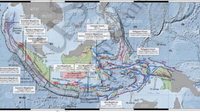
The Geological Agency of the Ministry of Energy and Mineral Resources (ESDM) has explained the definition of megathrust and its distribution throughout Indonesia.
Supartoyo, a Senior Expert Earth Investigator at the Geological Agency, explained that a megathrust is a meeting zone between two tectonic plates, where one plate subducts beneath another. This zone has the potential to generate earthquakes with a magnitude of 8 or higher.
“Megathrust is essentially a zone where two different types of plates meet, where one plate subducts under the other. The meeting point at a depth of less than 50 km is what is called a megathrust,” he stated, as quoted from the @kesdm Instagram account on Monday (28/9/2026).
“Why is it called megathrust? The term comes from two words: first, ‘mega’, meaning large, and ‘thrust’, referring to an upward fault. Therefore, megathrust refers to an earthquake source capable of producing magnitudes of 8 or greater than magnitude 8,” he explained.
How significant is the megathrust potential in Indonesia?
He detailed that, based on Indonesia’s geotectonic maps, the distribution of megathrust zones is quite extensive. These include West Sumatra, South Java, South Bali, Nusa Tenggara, Northern Sulawesi, Northeast North Sulawesi, and Northeast Halmahera.
“These regions are suspected to possess megathrust zones capable of producing earthquakes with magnitudes of 8 or greater. Examples include the 2004 Aceh earthquake and the 2005 Nias Island earthquake, which reached a magnitude of 8.5,” he noted.
However, he admitted that the timing, location, and magnitude of earthquakes cannot yet be predicted with certainty.
“In reality, earthquakes cannot be predicted to date in terms of when, where, and how large they will be. This has not been answered definitively, although several methods are being developed; however, the results are not yet encouraging. Nevertheless, through science and technology, we can identify areas prone to earthquakes and tsunamis. The Geological Agency of the Ministry of ESDM refers to these as Earthquake Disaster Prone Areas (KRBG) and Tsunami Disaster Prone Areas,” he explained.
“The maps published by the Geological Agency serve as the primary basis for conducting mitigation efforts and spatial planning,” he added.
Why has the megathrust issue resurfaced in the public consciousness?
“The megathrust issue recurs periodically. I remember it first gained attention after the 2004 Aceh earthquake and tsunami. Since 2005 until now, it has recurred and consistently caused panic. Therefore, what is needed is an increase in public understanding and knowledge regarding megathrust,” he urged.