
Tidal Floods Inundate Surabaya Coastline, Disrupting Schools and Economic Activity
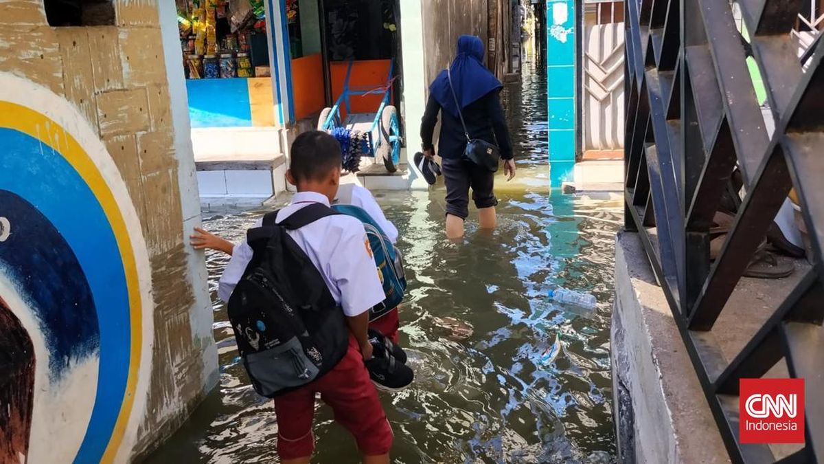
Tidal flooding (rob) was reported to have inundated Surabaya’s coastal areas on Wednesday (15 July), including the Kalianak area of Krembangan district. A school in the area was affected, disrupting teaching and learning activities.
One of the schools affected is SD Yayasan Karya Putra. Each time seawater overflows and floods the school grounds, the learning atmosphere there changes drastically compared with ordinary days.
On their way to school, pupils may wade through floodwater as deep as 30-40 cm, while inside classrooms the water can reach 10-15 cm. They are forced to remove their shoes to keep them dry.
Yuli (44), a teacher at SD Yayasan Karya Putra, said the school always adapts its teaching methods to the flood-stricken environment.
“Two classes suffered the worst impact with ankle-deep water, but we did not send the students home because these lessons are compulsory and coincide with the School Environment Introduction Period (MPLS),” Yuli said on Wednesday (15 July).
Yuli said the tidal flooding has occurred routinely two to three times a month since the school was established in 1998. Although the school has made do with makeshift infrastructure repairs, funding constraints mean flood mitigation has not been optimal.
“When the rob comes, the students are used to wearing sandals and have to be carried to and from school by their parents,” Yuli added.
Another teacher, Nanda (60), observed that the floodwater has actually risen higher since the Kalianak River normalisation project began, located just a few metres behind the school.
“We are worried because we feel the water entering the school has got deeper since the normalisation project was carried out, so we very much hope there are parties who care and will help address this situation,” Nanda explained.
Meanwhile, Hendro, a resident of East Kalianak, confirmed that tidal flooding has battered their area for the past 63 years, with water levels reaching more than 50 centimetres.
“Residents can now only resign themselves to monitoring tidal information to anticipate the impacts, both on economic activity and our children’s education,” he said.
The Meteorology, Climatology and Geophysics Agency (BMKG) at the Class II Tanjung Perak Maritime Meteorological Station in Surabaya stated that several coastal areas of Surabaya have been inundated by tidal flooding since 12 July, predicted to continue until 17 July 2026.
Sutarno, Coordinator of Observation and Information at the station, confirmed that water levels on Jalan Kalimas and in Kalianak have reached 15-29 centimetres.
Main roads and residential areas are submerged, including Jalan Kalimas and the Kalianak area, triggering traffic congestion as motorists must take extra care crossing the floodwater.
“The areas affected by the tidal flooding are the Kalianak area and Jalan Kalimas in Surabaya,” Sutarno said.
According to BMKG Maritime forecasts, the tidal flooding hitting Surabaya’s coastal areas and other parts of East Java will last six consecutive days.
The threat has been triggered by an extreme monthly astronomical cycle, in which the positions of the Earth, Moon and Sun combine to produce maximum sea tides.
“The maximum sea tide occurring at present is part of the Moon’s monthly cycle, currently at the new moon phase,” he said.
The BMKG urged communities along the coastline to remain fully alert to rising sea levels, predicted to reach 120-160 centimetres above sea level.
“This condition has the potential to cause tidal flooding in coastal areas reaching 120 to 160 centimetres above mean sea level,” he said.
Sutarno estimated that the peak of the sea-level rise will occur daily in a window from morning to midday, specifically between 09:00 and 12:00 Western Indonesia Time (WIB).
The flooding is predicted to disrupt economic activity and residents’ daily mobility, particularly maritime transport, logistics activities, port loading and unloading, tourism, and fishpond fishermen’s work.
“This phenomenon produces standing water 10 to 40 centimetres deep on land, which can disrupt transport around ports and coastal areas, the activities of salt farmers and fisheries, as well as loading and unloading operations at ports,” Sutarno explained.
He added that the tidal flooding can also cause physical and infrastructure damage as saltwater submerges houses, vehicles and roads.
“Metal components in vehicles and buildings suffer corrosion due to the salt content of seawater,” he said.
In addition, dirty floodwater from the tidal flooding carries the risk of skin diseases, itching, coughs and diarrhoea. Clean water becomes scarce, and the environmental impact is also damaging.
“Tidal flooding contaminates freshwater sources, making it difficult for residents to obtain clean water. Worsening coastal abrasion erodes coastal land and can damage mangrove ecosystems,” he said.
According to Sutarno, the coastal areas of Surabaya and its surroundings deserve serious attention because of the wide extent of the impact. The BMKG has mapped several critical points in Surabaya that fall within the red zone of vulnerability to tidal flooding.
“Coastal areas with the potential to be affected include the port areas of North Surabaya and Benowo, then East Surabaya, including Kenjeran and Sukolilo. In addition, West Surabaya, including buffer areas such as Gresik, Lamongan and Tuban, must also stay alert,” Sutarno outlined.
The tidal flooding is projected to spread beyond Surabaya to various other coastal areas of East Java. Based on BMKG estimates, affected areas include the southern coast up to Madura, bordering the Madura Strait directly.
“The potential impact also extends to Banyuwangi, Pasuruan, Sidoarjo, Probolinggo, Jember, South Bangkalan, Kuanyar, Sampang, along the Madura Strait, up to the Kreseh area in the western part of Sampang,” he said.
To address the prolonged impact of the flooding, the BMKG has recommended a number of mitigation measures to the government.
“For handling efforts, the first is building embankments, preparing water pumps, carrying out drainage repairs, and finally mangrove conservation,” he concluded.