
Strategies to Address the Surge in Forest and Land Fires
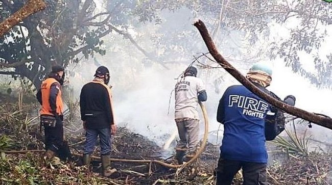
Speed and alertness are needed to tackle forest and land fire disasters. IPB University Professor Bambang Hero Saharjo stated that there has been a surge in the area of forest and land fires, reaching nearly a 19-fold increase in the first four months of 2026. According to him, this is not merely a statistical anomaly but a strong signal of a Runaway Climate Impact, where the climate impact has run beyond the control of human prevention systems. The drastic increase in forest and land fire cases this year proves that natural mechanisms are currently far stronger than the existing protection systems. It must be noted that normal fire alert strategies are no longer relevant for facing this year’s extreme situation.
Natural mechanisms have become so strong that they have broken through our fire prevention systems. On the other hand, mitigation conditions remain concerning because there are indications of initial response failure. Although danger signs have been visible since the beginning of the year, some government agencies even declared conditions safe last April, just as fires began to consume parts of the region.
A strategy for tackling the surge in forest and land fires was proposed by an aviation technology expert from ITB, Hisar Manongan Pasaribu. He is also the Co-founder and CEO/Head of Design Organization of PT Iter Aero Industri, a company whose design organization and production facilities are located in Cilampeni, Ketapang, Bandung. Regarding forest and land fire solutions, Hisar and his team have designed drone applications and Bambi Buckets. According to him, the main problem with forest and land fires is the difficulty of early detection. However, prevention through early detection is crucial and must be pursued. Drones are needed with a Fire Monitoring and Suppression System capability equipped with AI-driven hotspot prediction detection. These utilise satellite data (NASA) and meteorological inputs (NOAA) to predict potential fire hotspot zones with an accuracy rate of 98.6 percent.
Furthermore, multi-sensor integration is necessary. Advanced drones use optical cameras, infrared sensors, and Synthetic Aperture Radar (SAR) to detect fire and smoke even in low visibility conditions (night, fog, or thick smoke). Deep learning models like AMSO-SFS can improve detection with simultaneous spatial and frequency analysis features. Drones can perform real-time monitoring during autonomous patrols, providing continuous surveillance without blind spots. Using autonomous firefighting drones equipped with fire retardant sprayers or payload release systems, drones can be operated immediately to extinguish small fires before they spread into large blazes. Compared to aeroplanes and helicopters, drones can fly lower and closer to the fire zone and then apply retardant directly to hotspots more efficiently and effectively. The payloads that can be carried by drones include fire extinguisher balls, dry chemical agents, and water capsules for small fires.
Research and development of drones with various functions and missions are very important for Indonesia. One developer is Iter Aero, which has provided innovations to meet increasingly diverse needs with drone applications. On 1 October 2025, Iter Aero successfully obtained Design Organization Approval (DOA) Class D from the Ministry of Transportation. This confirms recognition of its full capability in designing aircraft and RPAS that are of high quality and meet international standards. It should be noted that DOA is a formal, internationally recognised DKKPU procedure for certifying a design organisation’s capability to carry out the design and certification of aircraft and aeronautical products meeting airworthiness, safety, and environmental standards. As a DOA holder, Iter Aero works based on a Design Organization Manual that has been approved to maintain a Design Assurance System. Thus, Iter Aero is able to consistently carry out the design, production, and assembly of quality, standard-compliant aircraft (drones and remotely piloted aircraft systems) on a mass scale.
Iter Aero has fulfilled Type Certificated Drones and RPAS. Type Certification is a formal, internationally recognised procedure from the Ministry of Transportation to validate and certify an aeronautical product (aircraft or RPAS) to meet international standard airworthiness, safety, and environmental requirements. Drones/RPAS produced by Iter Aero can operate simultaneously and autonomously without human pilot intervention from take-off to landing with a high level of safety. With certified drones, operators can obtain repetitive operating permits and independently fly drones within the operational limits set in their operations manual. Iter Aero’s drone and RPAS products can be customised as platforms equipped with various sensors and payloads to carry out various missions and operations. The types of drone products include the Agriculture Drone IA-20AG, IA-740 Cargo Drone, Multipurpose Multicopter Drone, and Multicopter Cargo Drone.
Ad-hoc solutions to tackle forest and land fires by deploying personnel to extinguish fires en masse by spraying water from portable pipes are less effective for overcoming the disaster. Technological innovation is needed to perfect forest and land fire mitigation. This solution includes irrigation network systems and early monitoring systems for fire occurrence.