
Shifting Wind Directions Complicate Forest Fire Suppression at Mount Ciremai, 40 Hectares of Forest Burnt
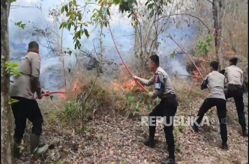
Joint personnel continue to work tirelessly to extinguish forest and land fires occurring in the Mount Ciremai National Park (TNGC), Kuningan Regency, on Wednesday (9/9/2026). Over the last three days, the fire has burnt approximately 40 hectares of forest area within the TNGC.
Throughout the day, a joint team consisting of elements from the Regional Disaster Management Agency (BPBD), TNI, Polri, TNGC, volunteers, and local residents have been working hard to suppress the spreading fire hotspots. They are conducting firefighting operations using jet shooters, pump engines, and four-wheel-drive vehicles belonging to the TNGC.
In addition, the joint team is also performing manual firefighting using tree branches. This is due to the significant distance between water sources and the fire locations.
The Head of the Kuningan Regency BPBD, Indra Bayu Permana, explained that the joint team is facing several obstacles in their suppression efforts. In addition to the difficulty of accessing water, factors such as wind, steep terrain, sharp rocks, and hot weather have made the firefighting efforts particularly challenging.
“The wind direction changes quite rapidly, sometimes to the east, sometimes to the south. There were moments when several colleagues were surrounded by fire. However, thankfully, everyone is safe and no accidents have occurred,” said Indra.
He noted that the extent of the forest fire in the TNGC has now reached an estimated 40 hectares, with the burnt area being dominated by rosewood (sonokeling) trees.
The fire was first detected by the appearance of smoke plumes in the TNGC area at the Cileutik Block, Singkup Village, Pasawahan District, Kuningan Regency, on Monday (7/9/2026) at around 12:00 WIB. The fire subsequently spread to the Cimaung and Manguntapa Blocks.
As of Wednesday (9/9/2026) at 20:00 WIB, no active fire hotspots were reported. However, officers are still conducting containment and mop-up cooling operations to prevent the fire from reigniting.
Source: jawawa.id (https://jawawa.id/newsitem/shifting-wind-directions-complicate-forest-fire-suppression-at-mount-ciremai-40-hectares-of-forest-burnt-1788979914)
Originally published by Republika (https://rejabar.republika.co.id/berita/tl3ynx282/perubahan-arah-angin-persulit-pemadaman-karhutla-gunung-ciremai-40-hektare-hutan-hangus), translated from Indonesian