
Shallow Crustal Earthquake Devastates Palu, Experts Identify Hazard Sources
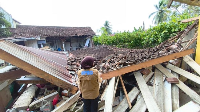
A tectonic earthquake measuring M6.7 struck the Torue area, Parigi Moutong, Central Sulawesi, on Tuesday (16/6/2026) at 10:27:44 WIB. The Meteorology, Climatology, and Geophysics Agency (BMKG) recorded the earthquake at a depth of 16 km. The epicentre was located at coordinates 1.03° S; 120.24° E, precisely on land 42 km southeast of Palu, Central Sulawesi. The earthquake was classified as a shallow crustal earthquake due to activity on the Sausu Fault. Source mechanism analysis indicates the earthquake had a downward movement (normal fault).
Official reports revealed damage to infrastructure and buildings in the affected areas. Sigi Regency recorded damage on the MMI VII intensity scale, followed by Palu City, North Parigi, and Poso on the MMI VI scale. Damage on the MMI V intensity scale also occurred in Parigi Moutong and South Banawa, while the Sindue, Balaesang, and Masamba areas reported impacts on the MMI IV scale. The National Disaster Management Agency (BNPB) reported that as of Wednesday (17/6/2026) at 06:00 WIB, the earthquake affected 1,834 households or 5,784 people. A total of 73 residents were reported to have minor injuries, while three others sustained serious injuries. The death toll remains at one person, with no additions from previous reports.
Daryono, a member of the Indonesian Association of Disaster Experts (IABI), explained that the M6.7 earthquake was classified as a shallow crustal earthquake. “This type of earthquake is typically triggered by active fault activity. The shallow hypocentre depth causes minimal seismic wave attenuation, so the concentration of energy release or maximum shaking is concentrated in the area around the epicentre,” Daryono said. This area includes the districts of Palu, Sigi, and Parigi Moutong. The shallow hypocentre condition triggers a very dominant near-field effect, where the amplitude of seismic waves does not experience significant damping before reaching the ground surface. “This is exacerbated by a sharp acoustic impedance contrast between the bedrock and the soft sediment layers filling the basin, which triggers a site amplification phenomenon or local resonance, making the duration and intensity of shaking at certain periods far more destructive for buildings with matching natural frequencies,” Daryono explained.
The earthquake was located in a complex deformation zone. Based on tectonic mapping, the epicentre is within the influence zone of a fault system that includes the Sausu Fault, Palolo Fault, Malei Fault, Parigi Fault, Tokararu Fault, the Saluki Fault Segment, and the Lorelindu Fracture Zone. “This earthquake has a normal fault mechanism. The Palolo and Sausu areas are in a pull-apart zone triggered by the dynamics of the Palu-Koro Fault. Imperfections or bends in the main strike-slip fault path cause the Earth’s crust in that area to stretch. As a result of this stretching, normal faults form to compensate for the pull,” he stated. Daryono noted that this is why the earthquake was destructive, as evidenced by BNPB reports detailing building and infrastructure damage. “These normal faults cause subsidence on the Earth’s surface, creating basins or depressions in the zone that are subsequently filled with sediment. This is the key to why the shaking from this earthquake became so destructive,” he added.
Daryono also highlighted the sequence of historical earthquake events in the same zone. “This earthquake is part of a history of significant seismicity. History records that an M4.5 earthquake occurred in this zone in 1983, followed by an M5.9 Palu-Poso earthquake in 1995. Seismic activity continued with an M4.8 earthquake in 2005. Additionally, there was an M6.6 Palu-Poso earthquake in 2017,” he detailed. “This series of events indicates the persistence of seismic threats, requiring a comprehensive understanding of the tectonic characteristics in this region. Bearing in mind that the Central Sulawesi region has a very active and complex fault system, mitigation must not only focus on the main fault zone but also on the branches of active faults around it, which are often overlooked but have the potential to trigger severe shaking,” Daryono stressed.
He warned that the M6.7 earthquake once again reveals the deep geological vulnerability of this region. “As a shallow crustal earthquake triggered by active fault activity, this event serves as a reminder that the seismic threat in Sulawesi does not only originate from the main Palu-Koro fault line but also from the complex fault branches surrounding it,” he asserted. Tectonically, the Palolo and Sausu area is a pull-apart zone formed by the dynamics of the Palu-Koro Fault. “The lesson from this earthquake is very clear: the need for a paradigm shift in mitigation. We can no longer focus only on the known main fault lines but must immediately accelerate seismic microzonation mapping to a more detailed level. Local governments need to make this vulnerability data the primary reference in spatial planning, including restricting development on active fault zones. Given this complexity, preparedness is no longer an option but an absolute necessity for survival in active seismic zones like Central Sulawesi,” Daryono concluded.