
Severe Forest Fires Engulf Kalimantan, BNPB Responds
The island of Kalimantan is covered in red circle markers on the Google Maps application. The red dots, labelled ‘severe fire’, appear to be spread across various regions of Kalimantan, with the highest density in South Kalimantan.
This phenomenon has captured the attention of netizens who are concerned about the condition of forest and land fires (karhutla) in Kalimantan. Many social media users have highlighted the potential impact of smoke haze and the risk of drought.
Based on CNBC Indonesia’s monitoring on Thursday (20/8/2026), the red dots are widely distributed across the entire island of Kalimantan, from North Kalimantan to South Kalimantan.
The issue has also become a hot topic of discussion on social media platform X (formerly Twitter). One X user admitted that they initially opened Google Maps for work purposes, but their attention was diverted by the large number of fire indicators in Kalimantan.
‘Sorry to interrupt your scrolling. Just wanted to share some information. Every corner of the Indonesian part of Kalimantan is on fire. Each fire point is very large and extensive. It could be twice the size of Central Jakarta and 1.3 times the size of Denpasar city,’ they wrote.
Another netizen shared a video showing the current conditions on the ground. Thick smoke can be seen blanketing a road in Kalimantan, which has sparked the hashtag #PrayForKalimantan.
‘If you are curious about how dangerous and how close the forest and land fires are to residential areas in Kalimantan, look at this! I hope aid is distributed quickly, I hope rain comes soon, and I hope there is a solution that can resolve this problem. Pray for Kalimantan,’ wrote a user while uploading video and photo documentation.
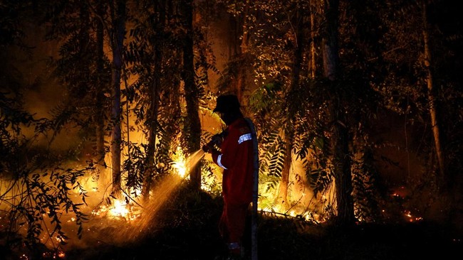
Responding to the phenomenon, the Head of the BNPB Disaster Data, Information, and Communication Centre, Berton SP Panjaitan, stated that the Task Force (Satgas) for handling forest and land fires, both ground and air teams, continues to work to extinguish the fires in several affected provinces.
‘However, so far there have been no airport closures due to the forest and land fires,’ said Berton in a written statement to CNBC Indonesia.
Forest and land fires are not a new issue in Indonesia. Historical records show that this ecological disaster has repeatedly struck the regions of Sumatra and Kalimantan, triggering economic losses of fantastic value and cross-border health crises.
Citing the official website of the Indonesian Young Geoscientists Forum (FGMI), the first large-scale forest and land fire in modern Indonesian history was recorded in East Kalimantan during the 1982-1983 period.
At that time, the El Nino climate phenomenon triggered extreme drought from June 1982 to May 1983. Prolonged hot weather combined with shifting cultivation practices—using land burning methods for seasonal crops such as rice, cassava, and maize—became the main trigger of the flames.
The forestry sector became increasingly vulnerable due to illegal logging activities. Accumulated wood waste in forest areas became highly flammable fuel.
Based on FGMI data, the 1982-1983 fires consumed at least 3.2 million hectares of land in East Kalimantan. The World Resources Institute (WRI) estimated the total economic losses from the disaster reached US$9 billion.
After the 1982 tragedy, a series of severe forest and land fires continued to recur with similar patterns and triggers. Major fire waves were recorded again in 1997-1998, 2006, 2015, and 2019. These disasters not only paralysed local economic activity but also accelerated global warming and claimed lives.
Recent research by Annisa Musrifatun Nur’Aini and Athaya Putri Tatia Ananta from the Faculty of Forestry at Gadjah Mada University (2025), published in the BNPB disaster history literacy portal, confirms that most forest and land fire events in Indonesia are triggered by human (anthropogenic) activity.
The impact of weak land governance has even spread to neighbouring countries such as Malaysia, Singapore, and Brunei Darussalam through cross-border haze crises.
One of the worst events in the last decade occurred in 2015. The report recorded that the area burned reached 2.6 million hectares. This disaster caused hundreds of thousands of people to suffer from acute respiratory infections (ISPA) and claimed dozens of lives.
The practice of land clearing by burning continues to be practised because it is considered the cheapest and most instant method, both by corporate actors and small-scale farmers. However, this false efficiency creates systemic impacts that harm the national economy in aggregate.
The risk of forest and land fires escalates further when entering the dry season. Canal construction (canalisation) in peatlands worsens conditions by drying out the natural ecosystem. Peat that loses its moisture triggers the emergence of fires below the ground surface (subsurface fire), a type of fire that is very difficult to detect and takes a long time to extinguish.