
Reasons for Continued Rain Despite the Dry Season, BMKG Issues New Warning
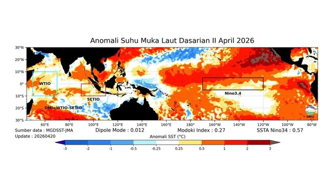
The Indonesian Meteorological, Climatological, and Geophysical Agency (BMKG) has repeatedly warned of the potential for an El Niño event in Indonesia. Influenced by El Niño, the dry season in Indonesia in 2026 is predicted to be drier and longer. This climate phenomenon is forecasted to affect Indonesia in the second semester, coinciding with the 2026 dry season. There is a 70-90% chance of a weak to moderate El Niño occurring. On the other hand, BMKG records that, based on the number of Seasonal Zones (ZOM), 73 ZOM or 10.4% of Indonesia’s territory is currently experiencing the dry season. Quoting the Analysis of Atmospheric Dynamics for the Second Decade of April 2026 released by BMKG today, Thursday (23/4/2026), the areas currently in the dry season include parts of Aceh, small parts of North Sumatra, small parts of Riau, parts of Riau Islands, small parts of Banten, small parts of West Java, small parts of Central Java, small parts of Bali, parts of West Nusa Tenggara, small parts of East Nusa Tenggara, parts of Gorontalo, parts of Central Sulawesi, parts of South Sulawesi, parts of Southeast Sulawesi, and parts of Maluku. BMKG has also issued an early warning for potential meteorological drought in the Third Decade of April 2026 in several districts in Aceh Province. The classification of this warning is Alert. Meanwhile, there are no early warnings for Caution and Warning levels from BMKG. On the other hand, BMKG has also issued an early warning for potential high rainfall in the Third Decade of April 2026. This warning applies to: - Alert: Several districts/cities in Aceh Province, North Sumatra, West Sumatra, South Sumatra, West Java, Central Java, DI Yogyakarta, East Kalimantan, Central Sulawesi, South Sulawesi, and South Papua. - Caution: Several districts/cities in Aceh Province, Banten, West Java, East Nusa Tenggara, and Central Papua. - Warning: No warnings. So, why is there still rain even though Indonesia is in the dry season? BMKG Head Teuku Faisal Fathani emphasised that although the intensity of El Niño is predicted not to be as strong as in 2015, 2019, and 2023, its impacts still need to be anticipated. Especially since it coincides with the dry season period. Not only that, he also stressed that the dry season does not mean no rain at all. “The dry season and El Niño are two separate phenomena. What we are concerned about is when during the dry season, the El Niño phase is active. This is the condition that occurred in 2015, 2019, 2023, and is predicted to start in 2026. BMKG will continue to monitor so that future predictions are more accurate,” he said in a statement on the official website, quoted Thursday (23/4/2026). “Dry season does not mean no rain at all, but rather a condition when rainfall is below the climatological threshold,” Faisal explained. Potential Rain for the Week Period 21-27 April 2026 Meanwhile, BMKG reminds to be alert to uneven rain in various parts of Indonesia during the seasonal transition. BMKG notes that light to heavy rain occurred in several parts of Indonesia during the period 16-19 April 2026. This condition was triggered by the activity of several atmospheric waves, such as Equatorial Rossby and Mixed Rossby-Gravity (MRG) in some areas. The seed of Tropical Cyclone 92S in the southwest Indian Ocean part of Lampung. Also, cyclonic circulation in the waters west of Aceh, West Kalimantan, Banda Sea - Arafura Sea, and north of Papua waters triggered the formation of wind convergence areas, convergence, and confluence that increase the chances of rain cloud growth, both around the circulation centres and in areas affected by those wind patterns. In addition, daytime surface warming that is quite warm and air humidity that is still sufficiently moist in the lower layers also supports the formation of convective clouds that have the potential to cause rain. BMKG predicts that rain will still occur over the next week until 27 April 2026 due to the influence of other atmospheric dynamics. The Madden-Julian Oscillation (MJO) phenomenon is in phase 8, but its spatial filter is predicted to pass through Aceh. Kelvin waves are forecasted to be active in Sumatra Island, western Java Island, Kalimantan Island, Sulawesi Island, East Nusa Tenggara, southern Maluku, and Papua Island. Meanwhile, Equatorial Rossby waves are predicted to be active in Bali, West Nusa Tenggara, East Nusa Tenggara, southern Maluku, and South Papua. “Various atmospheric dynamics can support rain cloud growth in those areas,” BMKG wrote. BMKG Early Warning Period 24-27 April 2026 It is stated that the weather in Indonesia is generally dominated by light to moderate rain conditions. However, be alert to the increase in moderate to heavy rain occurring in Aceh, North Sumatra, West Sumatra, Riau, Riau Islands, Jambi, South Sumatra, Bangka Belitung Islands, Bengkulu, Lampung, Banten, West Java, Central Java, DI Yogyakarta, East Java, East Nusa Tenggara, Central Kalimantan, South Kalimantan, Gorontalo, Central Sulawesi, South Sulawesi, Southeast Sulawesi, North Maluku, Maluku, Southwest Papua, Central Papua, Papua Mountains, Papua, and South Papua. In addition, heavy rain accompanied by lightning/thunder and strong winds may occur in: - Caution (heavy to very heavy rain): Papua Mountains - Strong Winds: East Nusa Tenggara. Previously, BMKG warned of potential caution for heavy to very heavy rain in North Sumatra, West Sumatra, Bangka Belitung Islands, Bengkulu, West Java, Central Java, DI Yogyakarta, East Java, Bali, West Nusa Tenggara, South Sulawesi, Papua Mountains, and South Papua for the period 21-23 April 2026.