
Quake Felt Like a Passing Truck, Yet a Deadly 21-Metre Tsunami Swept the Coast
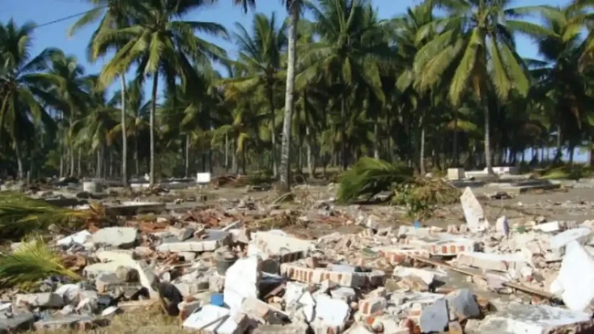
Jakarta, CNBC Indonesia - Exactly 20 years after the Pangandaran tsunami struck the southern coast of Java, experts warn that the event remains one of the most important lessons in disaster mitigation for Indonesia. Besides being recorded as the largest tsunami on Java Island after the 1994 Banyuwangi event, this disaster also became a turning point for strengthening the national tsunami early warning system and community preparedness. This was conveyed by Seismology Expert from the BMKG Earthquake and Tsunami Directorate Pepen Supendi, Professor at the Sumatra Institute of Technology (ITERA) Harkunti Pertiwi Rahayu, and Head of the BMKG Earthquake and Tsunami Information Working Team Weniza during a discussion commemorating the 20th anniversary of the Pangandaran tsunami, broadcast on the InfoBMKG YouTube channel on Thursday (16/7/2026). The Meteorology, Climatology, and Geophysics Agency (BMKG) recorded that a magnitude 7.7 earthquake that shook Pangandaran at 15:19 WIB on 17 July 2006 was the main trigger for a tsunami with heights of 4-8 metres in Pangandaran. The waves subsequently swept along 250 kilometres of the southern coast of Java, from Pangandaran through southern Central Java to the Yogyakarta area. The tragedy claimed 668 lives and destroyed the homes of thousands of residents, making it one of the deadliest disasters in Indonesia after the 2004 Aceh tsunami. Seismology Expert Pepen Supendi stated that the Pangandaran tsunami was the largest to ever occur on Java Island after the 1994 Banyuwangi earthquake and tsunami. The event also became one of the most important examples of a ‘tsunami earthquake’ phenomenon, which changed scientists’ understanding of tsunami generation mechanisms. According to Pepen, the Pangandaran tragedy was also a catalyst for accelerating the development of the Indonesia Tsunami Early Warning System (InaTEWS). Although the initiation of the system began after the 2004 Aceh tsunami, the 2006 Pangandaran event sped up its development until it was finally inaugurated on 11 November 2008. Pepen explained that the Pangandaran earthquake was categorised as a tsunami earthquake because the rupture process was very slow, emitting low-frequency energy. As a result, the shaking felt by the community was relatively weak, even though it was capable of triggering a large tsunami. At the time, people in Pangandaran only felt shaking of around 3-4 MMI (Modified Mercalli Intensity), leading many to believe the earthquake was harmless as the tremor merely felt like a passing truck. In reality, about an hour later, tsunami waves came crashing into the coastal area. Pepen reminded communities in coastal areas not to wait for sirens or official warnings if they feel a long-lasting earthquake, even if the shaking is weak. He stressed that such a sensation could be a sign of a tsunami earthquake and urged people to immediately move away from the beach, as every minute or even second can save lives. Pepen further explained that observations showed tsunami heights in Pangandaran and the southern coast of Central Java generally ranged from 5 to 10 metres. However, in the Nusa Kambangan area, the tsunami height was recorded at approximately 21 metres. He noted that several studies suggest this extreme height may not have been caused solely by the megathrust fault rupture. There are hypotheses of a local submarine landslide and the contribution of a splay fault that amplified the tsunami height. Regarding future threats, Pepen said the National Earthquake Study Centre has identified two megathrust segments in southern Java, namely West Java and East Java. Based on recent research, there is a worst-case scenario where both segments could rupture simultaneously. He emphasised that a magnitude 7.7 earthquake like the one in Pangandaran is already sufficient to cause massive destruction, making community preparedness the most critical factor. Professor Harkunti Pertiwi Rahayu added that the resilience of the tourism industry in Pangandaran remains a significant challenge. She noted that the recovery of the tourism sector after the 2006 tsunami took a very long time, and the current preparedness of the tourism industry is still not optimal. She also highlighted the need to standardise tsunami evacuation signs, as the current variety of signs often confuses the public. Meanwhile, Weniza stated that the current early warning system is much faster than in 2006. BMKG can now issue an early warning within three minutes after an earthquake occurs, a significant improvement from the 2006 era when the system was not yet operational.