
PRR Task Force Strengthens Mitigation in Areas Prone to Subsequent Disasters
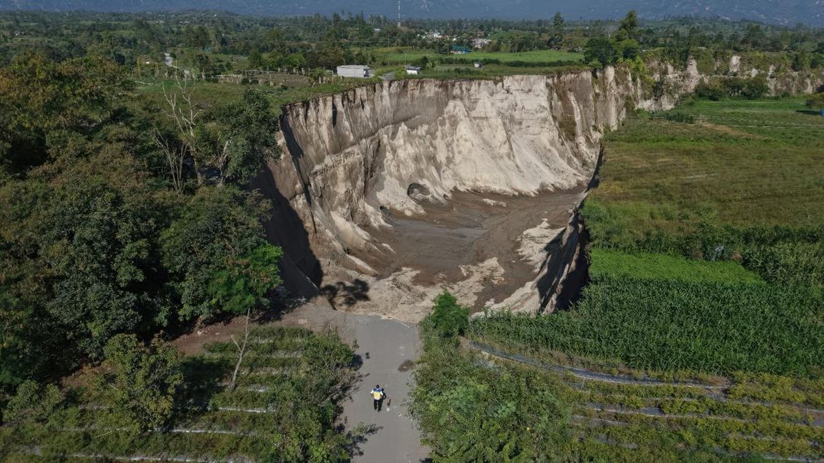
The Task Force for the Acceleration of Rehabilitation and Reconstruction (PRR) Post-Disaster in Sumatra is strengthening mitigation measures at several points prone to subsequent disasters in areas affected by hydrometeorological events in Aceh, North Sumatra, and West Sumatra. This effort is being undertaken to ensure the recovery process proceeds in tandem with enhancing public safety and long-term regional resilience.
One of the steps taken was a field visit by the Aceh PRR Task Force team, together with the Ministry of Public Works’ Balai Pelaksanaan Jalan Nasional (BPJN) Aceh and PT Hutama Karya, to the Enang-Enang Bridge area in Bener Meriah Regency and a sinkhole location in Pondok Balek Village, Ketol District, Central Aceh Regency, on Friday (12/6). Both locations are of concern because they still harbour residual post-disaster risks. In the Enang-Enang area, road and bridge damage was triggered by cliff landslides and flash floods. Meanwhile, in Pondok Balek, the land subsidence or sinkhole phenomenon has the potential to expand further and threaten agricultural land, road access, and electrical networks.
In the Tajuk Enang-Enang area, located on the Bireuen-Takengon Highway, precisely at the Simpang Lancang junction connecting Alur Cuncin and Menderak villages, public access was temporarily cut off due to road and bridge damage. This route has been a vital transport artery connecting the Gayo region with the northern coast of Aceh, as well as a distribution channel for agricultural and plantation products. Although residents have independently opened access so that vehicles can pass on a limited basis, BPJN Aceh has warned that the route still carries a high level of risk. Unstable soil conditions, steep terrain, minimal lighting, and serious damage to the existing bridge, including broken and tilted foundations, are the main factors requiring vigilance.
The PRR Task Force assesses that handling in the Enang-Enang area must be carried out cautiously, prioritising technical and geological studies. According to the team, merely opening temporary access is insufficient without ensuring the route’s safety for the community. Therefore, coordination between BPJN, the River Basin Agency (BWS), local governments, and related agencies continues to be strengthened in addressing the roads, bridges, cliffs, and river flows around the site. As a long-term solution, the government has prepared a plan to build a shortcut bridge, targeted to commence construction in 2027. While awaiting permanent construction, BPJN Aceh, through its Regional Work Unit 3, is maintaining alternative roads to preserve cross-central connectivity towards Takengon.
Similar attention is being given to the sinkhole phenomenon in Pondok Balek Village, Ketol District, Central Aceh Regency. Based on preliminary data from BPJN, the sinkhole is estimated to have a depth of up to 85 metres and covers an area of approximately three hectares. The phenomenon has resulted in the loss of residents’ agricultural land, the collapse of an electricity tower, and the severing of road access in the vicinity. In its activity report, the PRR Task Force noted that BPJN and PT Hutama Karya found the soil structure at the sinkhole site to be dominated by former volcanic ash material with very minimal rock content. ‘This condition makes the subsurface material more easily eroded, especially during high rainfall and when influenced by seismic activity,’ the Task Force wrote in its report. The team also recorded a change in the sinkhole’s development direction. Whereas previously the expansion tended to head towards the upstream of the Peusangan River, its movement is now monitored heading towards Laut Tawar Lake. Consequently, the PRR Task Force is emphasising daily monitoring, updating warning signs, and restricting public access to the danger zone as urgent measures to prevent casualties.