
Pray for Kalimantan Call Echoes as 1,106 Hotspots Detected
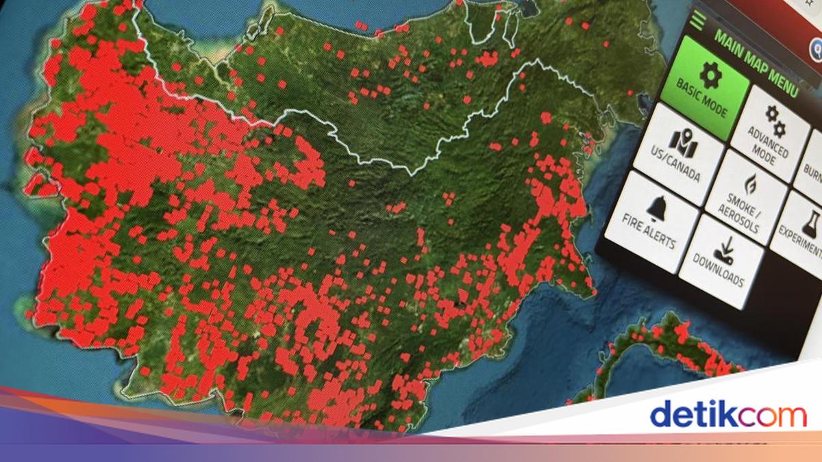
The call of ‘Pray for Kalimantan’ has been trending on social media. Netizens are highlighting the large number of hotspots visible on digital maps and satellite monitoring across several regions of Kalimantan.
Screenshots from Google Maps and NASA’s Fire Information for Resource Management System (FIRMS) map have been widely shared on X. The maps show indications of hotspots spread across West Kalimantan, Central Kalimantan, East Kalimantan, and several other areas.
Photos and videos showing thick plumes of smoke in various parts of Kalimantan have also been circulating. The situation has raised public concern over the impact of forest and land fires, particularly on residents’ health.
“Whether Kalimantan is being burned or is burning, what is certain is that millions of animals are victims, millions of trees are charred, millions of babies and people are struggling to breathe in the smoke #prayforkalimantan,” wrote @rebukanrain.
“I cannot bear to imagine millions of babies, children and people in Kalimantan having to struggle to breathe, living day after day amid thick smoke. Cigarette smoke alone makes you short of breath, let alone this forest fire smoke… astagfirullah,” said @assertndayy.
“Ya Allah, this is already really bad, pray for Kalimantan. May our brothers and sisters there be protected,” wrote @byunbaek0692.
“Pray for Kalimantan, may Allah’s power soon send rain to extinguish the forest and land fires,” prayed @han_javanese.
The Meteorology, Climatology and Geophysics Agency (BMKG) has detected thousands of hotspots across Indonesia, with the largest concentration in Kalimantan. Data from 20 August 2026 recorded 1,106 hotspots in Kalimantan.
The breakdown is 521 hotspots in West Kalimantan, 424 in Central Kalimantan, 103 in East Kalimantan, 40 in South Kalimantan, and 18 in North Kalimantan.
Meanwhile, data from the National Disaster Management Agency (BNPB) shows different figures due to different monitoring sources and methods. Based on NOAA-20 satellite monitoring on 20 August, there were 1,487 hotspots in Kalimantan, with Central Kalimantan accounting for 767 and West Kalimantan 560.
Dry conditions are increasing the risk of forest and land fires. BMKG has stated that El Niño is at strong intensity and most of Indonesia has entered the dry season. BMKG had previously warned that the risk of forest and land fires was expected to reach its highest level in August-September, including in West and Central Kalimantan.
The impact of forest and land fires is beginning to be felt in several areas. In Palangka Raya, Central Kalimantan, thick smoke haze has worsened air quality.
On 19 August 2026, the Air Quality Index (AQI) in Palangka Raya reached 487, a figure classified as hazardous.
A similar situation occurred in Banjarbaru, South Kalimantan. BMKG data on Wednesday (19/8) at 07.00 Wita showed PM2.5 particle concentrations reached 389.4 micrograms per cubic metre, also in the hazardous category.
PM2.5 particles are one of the main threats from smoke haze because they are very small and can penetrate deep into the respiratory tract. Children, the elderly and people with respiratory disorders are groups that require greater attention when air quality deteriorates.