
Pangandaran Tsunami 20 Years On: Weak Shaking, 21-Metre Waves, and Lessons for Disaster Mitigation
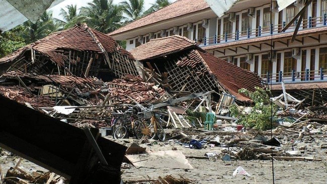
Twenty years after the tsunami struck Pangandaran, experts warn that the disaster remains a crucial milestone in strengthening Indonesia’s disaster mitigation efforts. The event prompted an overhaul of the tsunami early warning system and increased public awareness of the importance of preparedness. The Meteorology, Climatology, and Geophysics Agency (BMKG) recorded that a magnitude 7.7 earthquake on 17 July 2006 triggered a tsunami with waves reaching 4 to 8 metres in Pangandaran. The waves swept across 250 kilometres of the southern coast of Java, from Pangandaran through southern Central Java to Yogyakarta. The tragedy claimed 668 lives and destroyed thousands of homes, making it one of Indonesia’s deadliest tsunamis after the 2004 Aceh disaster.
Seismologist Pepen Supendi from BMKG’s Earthquake and Tsunami Directorate stated that the Pangandaran tsunami was the largest to hit Java since the 1994 Banyuwangi event. It became a key example of a ‘tsunami earthquake’, a phenomenon that altered scientific understanding of tsunami generation. The disaster also accelerated the development of the Indonesia Tsunami Early Warning System (InaTEWS), which was officially launched in November 2008. Pepen explained that the earthquake’s rupture process was very slow, causing only weak shaking of 3 to 4 MMI, which residents described as feeling like a truck passing. This led many to believe there was no danger, yet a deadly tsunami arrived approximately one hour later. He urged coastal communities not to wait for official warnings if they feel prolonged shaking, no matter how weak, and to immediately move away from the shore.
Observations showed that while tsunami heights in Pangandaran and southern Central Java generally ranged from 5 to 10 metres, the maximum run-up in the Nusa Kambangan area reached 21 metres. Pepen noted that this extreme height suggests a secondary source beyond the megathrust rupture, with hypotheses pointing to a local submarine landslide and the contribution of a splay fault. He also highlighted that the National Earthquake Study Centre has identified two megathrust segments south of Java, with worst-case scenarios indicating they could rupture simultaneously. He stressed that even a magnitude 7.7 earthquake, like the one in Pangandaran, is sufficient to cause massive destruction, making public preparedness the most critical factor.
Harkunti Pertiwi Rahayu, a professor at the Sumatra Institute of Technology, emphasised the need to strengthen the resilience of the tourism sector through a Business Continuity Plan. Pangandaran is a rapidly growing National Tourism Strategic Area, but the 2006 tsunami showed the sector was one of the hardest hit and took months to recover. Her assessment found that the overall resilience level of Pangandaran’s tourism industry currently stands at only 33.51 percent. She urged local government and businesses to improve the area’s resilience to ensure a faster recovery should another disaster strike.