
Outside Danger Radius, Managers State Tanjung Lesung is Safe to Visit
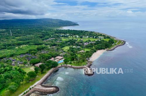
The volcanic ash from Mount Anak Krakatau, located in the Sunda Strait waters, remains a focus for the authorities. Nevertheless, the Tanjung Lesung tourism area in Pandeglang Regency, Banten, is reported to be safe for tourists to visit.
Various tourism supporting facilities, ranging from accommodation and culinary areas to open recreational spaces along the coast, are operating as usual. Dr Ir Mochamad Nugraha Kartadinata, an Earth Researcher from the Geological Agency of the Indonesian Ministry of Energy and Mineral Resources, stated during a field inspection that the geographical distance between Tanjung Lesung and the focus of the eruption reaches 50 kilometres. He noted that this figure far exceeds the 3-kilometre sterile zone established by the government.
“Krakatau not only possesses an extraordinary geological history but is also an important part of Banten’s natural wealth and tourism potential. By following official government monitoring and regulations, Tanjung Lesung can be a comfortable and safe tourist destination to visit,” he said, while attending alongside volcanic expert from the Bandung Institute of Technology (ITB), Dr Eng Ir Mirzam Abdurrachman, during a written statement received by Republika late last weekend.
He explained that as long as tourism activities are conducted outside the recommended sterile boundary, the public does not need to feel excessive anxiety. “Because the radius that must not be entered for activities is only 3 kilometres from the centre of the eruption. Therefore, if you want to come for tourism, I believe there is no problem,” he added.
Regarding the area’s operations, cross-agency coordination serves as the primary foundation for maintaining information transparency. The area managers continue to monitor data updates published periodically by BMKG, PVMBG, and the local government to ensure all preventive measures are based on measurable scientific parameters.
Nevertheless, this natural activity does not have a direct impact on the conditions on the mainland of Tanjung Lesung. The division of geographical zones and the significant distance ensure that the lives of local communities and the rhythm of travellers holidaying in this coastal area continue without hindrance.
Data from the Centre for Volcanology and Geological Hazard Mitigation (PVMBG), Geological Agency, Ministry of Energy and Mineral Resources as of 11 September 2026 (monitoring period 06:00–12:00 WIB) recorded the status of Mount Anak Krakatau at Level III (Alert). In the periodic report, weather conditions around Mount Anak Krakatau were observed to be clear to cloudy with light to moderate winds blowing towards the northwest.
Air temperatures ranged from 26.5 to 29.5 degrees Celsius with humidity levels between 67–83 per cent. Visually, the mountain’s body was covered by thin to moderate fog, while thin white smoke at moderate pressure could be seen rising 10 to 50 metres from the main crater.
The official report compiler from PVMBG, Fahrul Roji, urged the public and travellers to comply with physical activity restrictions within a 3-kilometre radius of the active crater centre. He also reminded the importance of filtering information and only referring to official directives issued by the PVMBG and the local Regional Disaster Management Agency (BPBD).
Source: jawawa.id (https://jawawa.id/newsitem/outside-danger-radius-managers-state-tanjung-lesung-is-safe-to-visit-1789369398)
Originally published by Republika (https://ameera.republika.co.id/berita/tlcawj425/berada-di-luar-radius-bahaya-pengelola-sebut-tanjung-lesung-aman-dikunjungi), translated from Indonesian