
Not Just El Nino: The Causes Behind Indonesia's Recurring Forest Fires
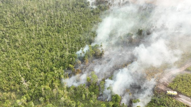
Forest and land fires (karhutla) that regularly hit various regions in Indonesia, especially Kalimantan and Sumatra, are often associated with the impact of global climate phenomena such as El Nino. However, analysis from academics, non-profit environmental organisations, and the Meteorology, Climatology, and Geophysics Agency (BMKG) points to one conclusion. El Nino only acts as a provider of dry physical conditions, while the main source of fire comes from human (anthropogenic) activities.
Kalimantan and Sumatra have a long historical record of severe forest and land fire incidents. The first major recorded forest fire occurred in East Kalimantan in 1982. At that time, the El Nino phenomenon caused severe drought between June 1982 and May 1983. In addition to prolonged drought, shifting cultivation by burning new land for seasonal crop plantations (such as rice, sweet potatoes, and corn) was considered a triggering factor for forest and land fires. There were also illegal logging activities that left accumulations of wood waste and dense vegetation that were highly flammable.
The fires in the 1982-1983 period burned 3.2 million hectares of land in East Kalimantan. The World Resources Institute (WRI) reported that economic losses from the forest fires reached US$9 billion. After that, several major forest and land fire incidents occurred again with similar causes, including the 1997-1998, 2006, 2015, and 2019 fires. These incidents not only caused economic losses but also damaged the environment, triggered global warming, and claimed lives.
Data from the National Disaster Management Agency (BNPB) recorded 454 forest and land fire incidents in various regions of Indonesia. Meanwhile, data from the Ministry of Forestry’s Forest and Land Fire Monitoring System shows that from January to July, the total burned area reached 202,010.96 hectares. This figure jumped sharply compared to the end of June position of 107,465.47 hectares. This means that around 94,545.49 hectares burned in July alone, which made the area of forest and land fires in Indonesia nearly double within one month. Forest and land fire incidents are feared to continue increasing due to the influence of El Nino which is still ongoing and is expected to last at least until early next year.
The Kalimantan and Sumatra regions are dominated by peatlands. Naturally, a healthy peat ecosystem acts like a giant sponge that absorbs and stores massive amounts of water, making it resistant to fire. However, if the condition of the peatland has begun to be disturbed, for example due to land conversion, its ecological balance will be disrupted. Under these conditions, during the dry season, peatlands will become very dry to a certain depth and easily catch fire.
Peat contains organic fuel from the remains of plants, wood, leaves, and roots that have decomposed over thousands of years. In dry conditions due to canalisation or land drainage, peat loses its water-absorbing properties and turns into a very dense expanse of fuel. Canalisation is often carried out when land is opened for plantations. The construction of water canals for plantations and land conversion lowers the groundwater level. When the dry season arrives, the peat layer dries to a depth of several metres below the ground surface.
In dry conditions, a small fire can trigger a massive blaze due to the phenomenon of ‘underground fire’ (subsurface fire / smouldering) in peatlands. Unlike mineral soil forests where fire only burns the surface, in peatlands fire spreads below the ground surface through the pores of organic material. Combustion occurs without large flames (smouldering fire), but rather as hidden embers. Fires in peatlands are difficult to extinguish, can last for months, and can only be extinguished by intensive rain.
Fire below the peat surface is often invisible to the naked eye and protected from water bombing. Temperatures in the soil can reach extreme levels, causing water to evaporate before reaching the core of the fire. As a result, fires can persist for months and re-ignite at any time even though the surface appears to have been extinguished.
The emissions released are also significant. Peatlands store enormous carbon reserves. Peat burning produces very high carbon/greenhouse gas emissions as well as toxic smoke emissions that have a severe impact on respiratory health, such as the emergence of Acute Respiratory Infections (ISPA).
According to an expert from the Faculty of Forestry at UGM, Fiqri Ardiansyah, dry forest conditions alone are not enough to cause fire naturally. El Nino plays a role in creating ideal conditions, namely drying vegetation and lowering the groundwater level so that land becomes very sensitive and flammable. However, if there is no external ignition, fires will not occur. Fiqri highlighted that the practice of using fire in land clearing without adequate control is still the dominant factor. The method of clearing land by burning (slash and burn) remains a major contributor.