
New landmass appears near Anak Krakatau, experts explain
Jakarta (ANTARA) - The emergence of land visible around Mount Anak Krakatau in the Sunda Strait has drawn significant attention after various images and videos circulated on social media. This phenomenon appeared following a series of eruptions from Anak Krakatau in early September 2026.
The Meteorology, Climatology, and Geophysics Agency (BMKG) previously explained that eruptive activity can produce volcanic materials such as lava and fall debris, which can gradually alter the morphology of Mount Anak Krakatau.
However, BMKG emphasised that such changes cannot immediately be classified as the formation of new, extensive landmass without morphological verification.
So, is it true that new land has emerged around Anak Krakatau? Here is the explanation.
Land increases due to eruption materials
The Geological Agency of the Ministry of Energy and Mineral Resources (ESDM) explained on 24 September that, based on an evaluation of Sentinel satellite imagery, there has been an addition of land to the body of Mount Anak Krakatau.
This addition is located in the northwest to west-southwest sectors and is estimated to originate from the deposition of pyroclastic material and lava flows resulting from eruptions occurring between 4 and 6 September 2026. The Geological Agency calculates the increase in land area to be approximately 32.8 hectares.
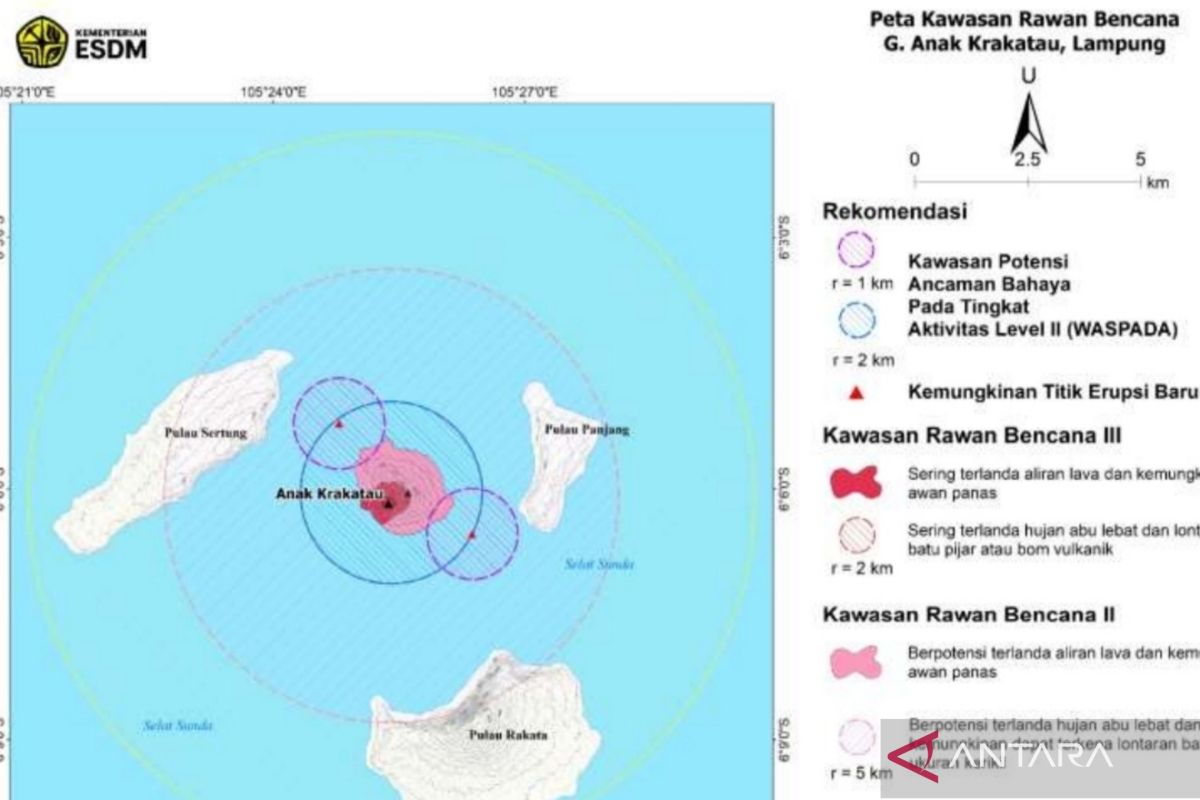
The Geological Agency also detected the presence of two small mounds or protrusions of land around the body of Anak Krakatau, located in the northwest and southeast parts of the volcano.
However, the existence of these two mounds cannot yet be confirmed as new islands or volcanoes. The Geological Agency stated that this interpretation is temporary and requires confirmation through direct field inspections.
The appearance of material protruding from the sea surface does not necessarily mean a new volcano has formed. Volcanic material expelled during an eruption can accumulate around the volcano, causing changes in the area’s morphology.
Daryono, a member of the Indonesian Disaster Expert Association (IABI) and a former BMKG official, explained that the visible land is an accumulation of volcanic materials such as ash, rocks, and lava from the Anak Krakatau eruption that have settled in the sea.
This accumulation process occurs gradually. The relatively shallow seabed conditions around the ancient Krakatau caldera area also allow eruptive materials to accumulate more easily until they eventually appear above the sea surface.
Anak Krakatau undergoes repeated eruptions
These morphological changes are linked to the increased volcanic activity of Anak Krakatau throughout 2026. The Geological Agency noted that Anak Krakatau has been erupting again since 2 July 2026, following a relatively long period of inactivity.
On 5 September 2026, Anak Krakatau experienced continuous eruptions accompanied by rumbling sounds. This phenomenon also produced lava flows, described as resembling a lava fountain.
On 8 September 2026, Anak Krakatau experienced two more eruptions, at 05:08 WIB and 05:34 WIB respectively. This activity was recorded via seismographs, although ash columns were not visually observed from the observation post.
BMKG previously emphasised that to state with certainty that new land has formed due to Anak Krakatau’s activity, morphological observation and monitoring of the volcano are required. This means that any landforms seen in visual recordings must be compared with conditions before and after the eruption and verified through field observations.
The Geological Agency also stated that the interpretation regarding the two mounds visible from satellite imagery still needs confirmation. Verification involves matching satellite imagery from before and after the eruption and conducting field inspections.
Current condition of Anak Krakatau
PVMBG previously stated that the physical growth of Anak Krakatau is occurring relatively rapidly, but this remains part of the dynamic formation process of a young volcano. On 17 September 2026, PVMBG noted that Anak Krakatau’s activity had returned to a Strombolian eruption pattern with short durations.
Nevertheless, the area around Anak Krakatau remains a cause for concern. The Geological Agency has advised the public not to approach within a 2-kilometre radius of the eruption centre. Specifically, for the location of the two mounds seen around Anak Krakatau, the public is requested to stay at least 1 kilometre away for safety.
Thus, the emergence of land around Anak Krakatau is indeed related to the accumulation of materials from volcanic activity. However, referring to the area as a new island or volcano still requires field verification. The morphological changes detected currently are part of the growth and volcanic activity process of Anak Krakatau.
Source: jawawa.id (https://jawawa.id/newsitem/new-landmass-appears-near-anak-krakatau-experts-explain-1790301461)
Originally published by Antara (Indonesian) (https://www.antaranews.com/berita/5757728/ada-daratan-baru-di-dekat-anak-krakatau-ini-penjelasan-ahli), translated from Indonesian