
New Land Emerges Near Anak Krakatau; Disaster Experts Clarify Situation
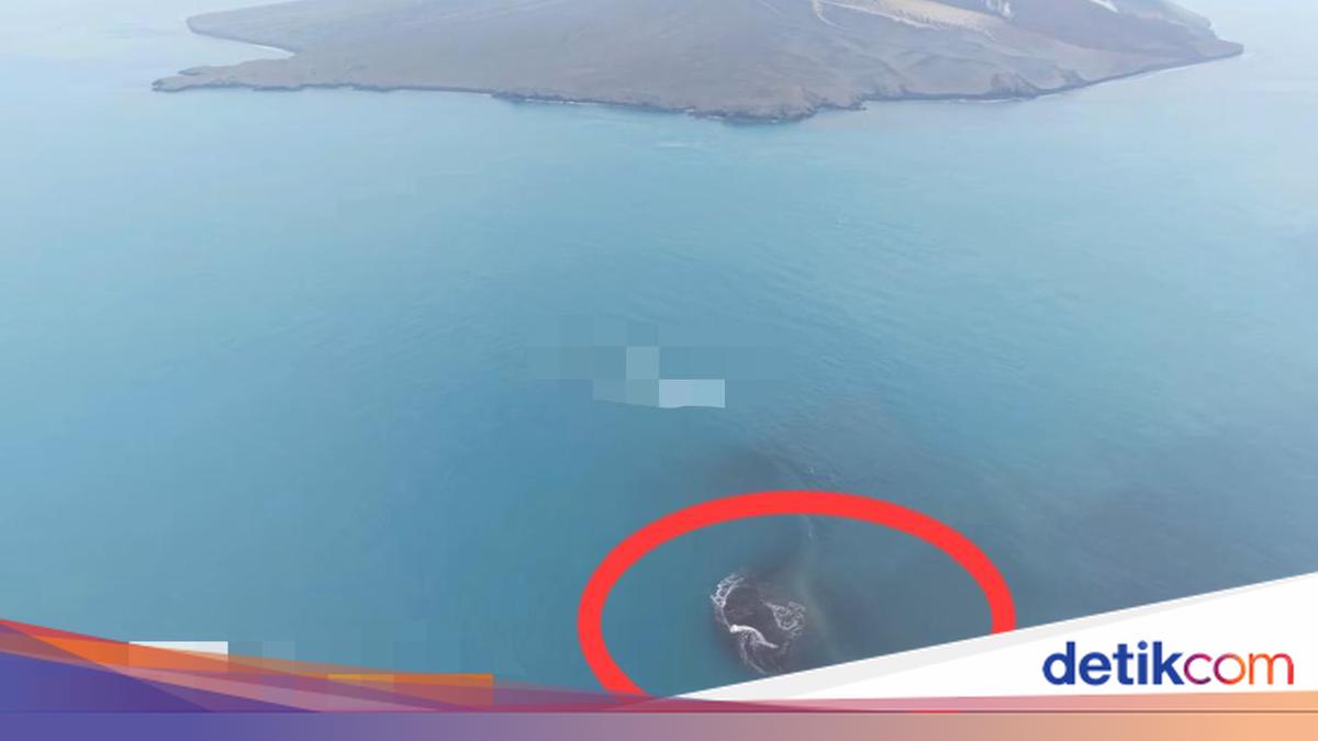
New land has emerged around Mount Anak Krakatau in the Sunda Strait following recent eruptions. Daryono Perwira Sakti, a member of the Indonesian Disaster Expert Association, has provided an analysis regarding this phenomenon.
The appearance of this new land initially triggered confusion and speculation regarding the emergence of a ‘grandchild of Krakatau’. However, according to Daryono, this land is not an independent volcano, but rather a deposit of volcanic material resulting from eruptions.
“The fact is, this land is not an independent volcano, but an accumulation of volcanic material such as ash, rocks, and lava from the eruptions of Mount Anak Krakatau that have settled in the sea. This accumulation process occurs gradually as the volcano’s activity increases, until the deposits eventually emerge above the water surface,” Daryono stated on his official X account on Thursday (24/09/2026).
He noted that the formation of new land between Mount Anak Krakatau and Sertung Island is influenced by a combination of geological and oceanographic factors. The seabed in the area of the ancient caldera, a remnant of the 188able eruption, is relatively shallow, allowing eruption materials to accumulate more rapidly.
Furthermore, Daryono explained that pyroclastic projections and lava flows during the eruption were predominantly directed towards that sector. Additionally, the dynamics of currents and waves in the Sunda Strait play a crucial role as agents of sedimentation, transporting light erosional material to calmer waters where it can settle permanently.
Regarding whether this new land will expand, Daryono stated that its condition depends heavily on the volcanic activity of Mount Anak Krakatau.
“Whether this land will grow or simply disappear again? The answer depends entirely on the struggle between volcanic activity and natural erosion,” he said.
“If Mount Anak Krakatau continues to erupt, the supply of new material will cause the land to expand further. Its stability will be strengthened if it is covered by molten lava that hardens into solid rock,” he added.
However, he noted that if eruptions cease, the impact of waves and marine abrasion could erode the uncompacted sand deposits, potentially causing the ‘new land’ to sink again. Underwater landslides or large explosive eruptions could also destroy the structure of these young deposits in a short period.
He outlined three geological requirements for land to be categorised as a new, independent volcano. First, the land must possess its own independent magma conduit connected directly to a magma chamber through a new fissure, separate from the parent crater. Second, the land must produce its own magmatic eruptive activity, ejecting magma or gas from its crater, rather than merely collecting discharge from a neighbouring volcano. Third, there must be its own geological structure and deformation, specifically the presence of local volcanic earthquake activity or ground swelling centred directly beneath the new land.
“In facing this phenomenon, the public is urged not to be easily provoked by speculative issues circulating on social media. The emergence of this new land is a common volcanic sedimentation process in active volcanic regions,” he said.
Previously, the Geological Agency revealed the emergence of two new ‘islands’ following the recent eruption of Mount Anak Krakatau, identified via Sentinel imagery.
According to the Geological Agency, the locations of these two new islands are northwest and southeast of Mount Anak Krakatsu. This extensive land is suspected to be part of the volcanic deposits from Mount Anak Krakatau.
“The emergence of these ‘two islands’ is believed to be related to continuous eruptions lasting approximately 25 hours,” said SS Rita Susilawati, Head of PVMBG, Geological Agency of the Ministry of Energy and Mineral Resources, on the Geological Agency’s social media on Thursday (24/09/2026).
Furthermore, new land has been reported to have reappeared in the area. The Geological Agency of the Ministry of Energy and Mineral Resources revealed that the new land covers an area of 32.8 hectares.
The emergence of this new land is situated between Anak Krakatau Island and Sertung Island in the Sunda Strait. This was also confirmed by the Head of the Anak Krakatau Volcano Monitoring Post. To provide perspective, the 32.8-hectare area is nearly as large as the Prambanan Temple complex, which covers 39.8 hectares.
The Geological Agency presented an evaluation based on Sentinel satellite imagery, showing an increase in land on the body of Mount Anak Krakatau in the northwest-west-southwest sector as a result of the deposition of pyroclastic material and lava flows from continuous eruptions between 4-6 September 2026.
Source: jawawa.id (https://jawawa.id/newsitem/new-land-emerges-near-anak-krakatau-disaster-experts-clarify-situation-1790244447)
Originally published by detikcom (https://news.detik.com/berita/d-8677501/heboh-daratan-baru-disebut-cucu-krakatau-ini-kata-pakar-kebencanaan), translated from Indonesian