
Nepal's Deadliest Floods in History
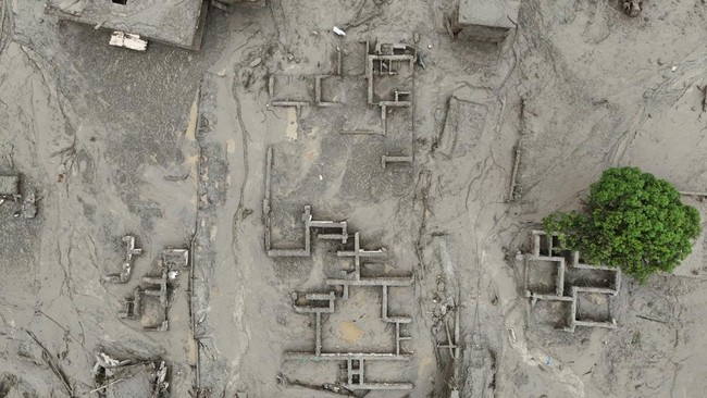
Nepal has again been hit by flash flooding. At least 157 people died in the flash flood that struck the Nepal-Tibet border area on Wednesday (26/8/2026). Hundreds more are still reported missing after ice, rock and mud swept into rivers and engulfed settlements.
This is not an isolated incident. Nepal has repeatedly faced major floods with varying scales of damage, from the bursting of glacial lakes in the Himalayas to extreme rainfall that paralysed Kathmandu.
In records from 1900-2005, a total of 2,740 flood events were recorded out of 13,525 natural disasters reported in Nepal. However, what is more striking is not the frequency. Of the approximately 7.4 million casualties from all disasters in that period, around 3.2 million deaths occurred in flood events. More than 2.8 million of these were recorded in the Tarai region. In other words, floods accounted for about a fifth of recorded disaster events but contributed around 44% of casualties.
Why is Nepal frequently flooded? Nepal is one of the countries vulnerable to flooding, especially during the monsoon season. Around 80% of Nepal’s annual rainfall occurs between June and September, so heavy rain in a short period can rapidly increase river discharge and trigger overflows. Nepal’s geographical location in the Himalayan region further increases the risk. Most of its territory consists of mountains and steep slopes, causing rainwater to flow rapidly from highlands to valleys and lowlands. This rapid water flow also increases the threat of landslides and flash floods.
The risk is exacerbated by Nepal’s extensive river network. The country has around 6,000 rivers and tributaries, including major rivers such as the Koshi, Gandaki and Karnali that originate in the Himalayan region and flow south towards the lowlands. When monsoon rains cause river discharge to surge, the potential for overflow increases.
In some cases, floods also occur together with landslides. Extreme rainfall can make mountain slopes unstable and trigger landslides of soil and rock that then dam river flows. When these natural dams burst, water mixed with landslide material can strike areas below as flash floods or debris flows.
Another threat comes from changing ice and glacier conditions in the Himalayas. Warming can accelerate glacier melt and increase water volume in glacial lakes. This condition has the potential to trigger glacial lake outburst floods (GLOFs), which are major floods that occur when the natural dam of a glacial lake bursts.
At the same time, climate change is making rainfall patterns increasingly difficult to predict. The World Bank estimates that changing rainfall patterns could increase the risk of floods and landslides in Nepal, including an increase in extreme rainfall events over periods of one to several days in certain areas.
Nepal’s vulnerability is also influenced by human factors. Limited land availability means many communities live near rivers, valleys and slopes that are at risk of floods and landslides. Urbanisation in mountainous areas also increases the number of people and assets located in vulnerable areas. With the combination of extreme monsoon rainfall, Himalayan topography, thousands of rivers, landslides, glacier melt, climate change and the concentration of settlements in vulnerable areas, Nepal faces a recurring and complex flood risk.
The form of Nepal’s flood disasters is also not always the same. In 1985, for example, what struck the valley was not merely river overflow. The Dig Tsho glacial lake burst after waves triggered by an ice avalanche entered the lake. Around 5 million cubic metres of water then swept into the Bhote Kosi and Dudh Kosi valleys. The scale is evident from the peak discharge reaching 1,600 cubic metres per second. Around 3 million cubic metres of debris material also moved over a distance of less than 40 kilometres.
In 2024, the threat came in another form. Extreme rainfall on 27-28 September caused nine monitoring stations in the Kathmandu Valley to record the highest rainfall since Nepal’s modern hydrological monitoring system began in 1970. The rain then triggered 132 landslides across various parts of Nepal. In Kathmandu, Lalitpur and Kavrepalanchowk alone, 57 landslides were recorded.
1.7 million affected, 1% of GDP eroded. One of the worst floods was in 2017. A total of 1.7 million people were affected and around 460,000 people had to be displaced when floods hit 35 districts of Nepal.
Seven years later, floods again showed a broader impact on centres of economic activity. The rainfall of 27-28 September 2024 was the heaviest recorded since Nepal’s modern hydrological monitoring system was built in 1970 at nine Kathmandu Valley monitoring stations. At least 236 people died and more than 8,400 people were displaced. In the Kathmandu Valley alone, 56 deaths were reported.
Damage also spread to infrastructure. A total of 22 hydroelectric power plants and nine transmission lines were damaged or destroyed, while 17 road sections were affected by landslides. The Nepalese government estimated initial economic losses at around 1% of the country’s Gross Domestic Product (GDP).
Source: jawawa.id (https://jawawa.id/newsitem/nepals-deadliest-floods-in-history-1787813494)
Originally published by CNBC Indonesia (https://www.cnbcindonesia.com/research/20260827123807-128-762707/daftar-banjir-nepal-paling-mematikan-dalam-sejarah), translated from Indonesian