
NASA Sensors Reveal Drastic Transformation of Nusantara Capital City from the Sky
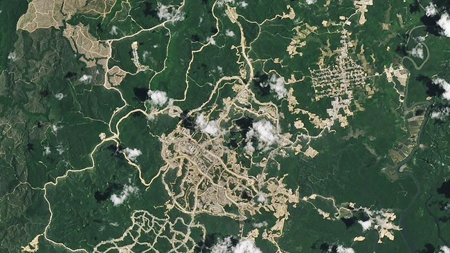
The United States space agency (NASA) has revealed the massive transformation occurring in the Nusantara Capital City (IKN) area through the latest satellite imagery released by NASA’s Earth Observatory. The photos show significant landscape changes in less than two years since construction began.
The images, captured using the Operational Land Imager-2 (OLI-2) sensor on the Landsat 9 satellite and OLI on Landsat 8, compare the condition of the IKN area in July 2022 and February 2024. From this comparison, it is clearly visible how areas previously dominated by forest have turned into large-scale construction zones.
‘IKN construction began in July 2022 in an area of forest and oil palm plantations about 30 kilometres from the Makassar Strait,’ wrote NASA’s Earth Observatory in its publication.
In the July 2022 image, the future capital city area was still dominated by expanses of green forest with a few access roads and scattered open areas. However, in the February 2024 image, a much more extensive and interconnected road network is visible, along with brown open land indicating massive construction activity.
In the central part of the area, a large construction cluster that is the centre of IKN development is also visible. Several areas previously covered by vegetation have been transformed into construction sites for various infrastructure, ranging from roads and government buildings to other supporting facilities.
According to NASA, the construction of the new capital is part of Indonesia’s effort to address various environmental challenges that have burdened Jakarta. The Jakarta metropolitan area, home to around 30 million people, faces multiple problems such as flooding, traffic congestion, air pollution, and limited clean water supply.
Jakarta also faces the ongoing threat of land subsidence due to excessive groundwater extraction. NASA notes that the rate of land surface subsidence in some parts of the capital reaches up to 15 centimetres per year. As a result, about 40% of Jakarta’s area now lies below sea level.
Nevertheless, the construction of IKN has also raised concerns from a number of environmental researchers. They assess that large-scale land use changes have the potential to disrupt ecosystems that have been habitats for various wildlife.
The area being developed as Indonesia’s new administrative centre is known for its high biodiversity. The region is home to mangrove forests, proboscis monkeys, and Irrawaddy dolphins.
Although the landscape changes are very striking from satellite imagery, IKN construction is still far from complete. The government targets the development of the new city to be carried out in stages until it reaches its final form by 2045.
The transformation recorded from outer space demonstrates the rapid pace of IKN construction in a short time, while also illustrating the magnitude of changes occurring in the East Kalimantan landscape since the national strategic project began.