
NASA Highlights Indonesia’s Forest and Land Fires, Issues Special Warning
Jakarta, CNBC Indonesia — The United States National Aeronautics and Space Administration (NASA) has drawn attention to high levels of forest and land fire activity in Kalimantan and Papua throughout 2026.
NASA warned that the surge in fires in both regions could trigger large carbon emissions amid drought caused by the El Niño phenomenon.
In a report on its official website, NASA said fire activity this year was exceptionally high in Kalimantan and Papua, particularly in Indonesian Papua, Papua New Guinea and eastern Indonesia.
The situation contrasts with Sumatra and several other parts of western Indonesia, where fire activity has been relatively lower than in previous drought years.
Yang Chen, a researcher at the University of California, Irvine, said fire activity this year was exceptionally high in Papua New Guinea and eastern Indonesia, especially Indonesian Papua and Kalimantan, compared with Sumatra and other parts of western Indonesia.
“Papua has emerged as a new frontier of deforestation in Indonesia,” Chen said, according to NASA’s website on Sunday (25 October 2026).
NASA also highlighted a surge in carbon emissions from fires on the island of New Guinea. According to the Global Fire Emissions Database (GFED), fires in Papua New Guinea had released nearly 32 million tonnes of carbon by 17 October 2026. That figure exceeds the total recorded for any other year over the same period.
Guido van der Werf, a scientist at Wageningen University & Research and a developer of GFED, estimates that this year’s emissions could be the highest on record in Papua New Guinea, surpassing even 1997.
Meanwhile, carbon emissions in Indonesian Papua have exceeded 35 million tonnes. This is the third-highest figure on record, behind 2015 and 1997, when El Niño also fuelled severe fires.
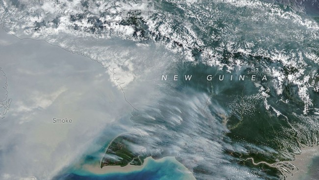
In the same report, NASA presented a NOAA-20 satellite image taken on 11 October 2026. It showed thick smoke billowing from the southern part of the island of New Guinea. During September and October, smoke blanketed much of the area for weeks.
Worsening air pollution led to some flights being delayed or cancelled and schools being closed, while local officials urged children and older people to wear masks.
Robert Field, a researcher at NASA’s Goddard Institute for Space Studies and Columbia University, said some smoke can be carried into higher layers of the atmosphere or washed out by storm rain. However, most remains close to the surface and worsens air quality.
“This is a terrible situation,” Field said.
NASA explained that changes to rainfall patterns caused by El Niño have made conditions on the island of New Guinea much drier and more vulnerable to fires. In southern Papua New Guinea, for example, there had been no rain for more than 90 consecutive days. Since August, rainfall in some areas has been only around 5–10 per cent of normal levels.
Researchers say most fires in the region are caused by human activity, including burning agricultural land, maintaining grazing areas, clearing forests and hunting.
In dry conditions, fires that are deliberately lit can spread and turn into uncontrolled wildfires.
Over the past two decades, NASA has recorded increased land clearing in Indonesian Papua for large-scale oil palm plantations, pulpwood crops, agriculture, urban expansion and mining.
Global Forest Watch data show that Indonesian Papua lost 27,000 hectares of primary forest in 2025. That was nearly double the figure for 2024 and the highest level since 2017.
NASA expects fires to continue until heavy rains arrive with the wet season in the southern part of the island of New Guinea, usually in early November.