
Mount Sinabung Activity Increases: Residents Evacuate Amid New Disaster Threats
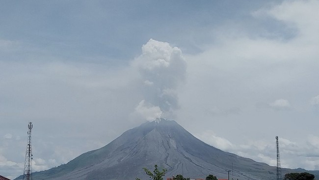
The National Disaster Management Agency (BNPB) has reported that residents of Kuta Tengah Village, Simpang Empat District, have evacuated to the Emergency Handling Post in Sukatepu Village, Naman Teran District, following increased activity at Mount Sinabung in Karo Regency, North Sumatra, as of Tuesday (1/9/2026).
This surge in activity follows an eruption of Mount Sinabung on Monday (31/8) at 12:00 WIB. The eruption produced an eruption column approximately 3,500 metres above the peak, or about 5,960 metres above sea level. Visual and instrumental monitoring indicates an increase in volcanic activity.
Consequently, the activity level of Mount Sinabung has been raised from Level II (Caution) to Level III (Alert), effective from 31 August 2026 at 12:30 WIB.
Meanwhile, the designation of the transition status from emergency to disaster recovery for the Mount Sinabung eruption in Karo Regency, based on Number 361/559/BPBD/2026, is valid for 90 days, from 8 July to 5 October 2026.
According to preliminary data from the BNPB, approximately 211 families, or 615 individuals from Kuta Tengah Village, are currently in evacuation centres. Meanwhile, residents of Payung Village, Payung District, remain in their homes but are on high alert.
“The local government, along with relevant agencies, continues to monitor the condition of the community in areas potentially affected,” said the Acting Head of the BNPB Disaster Data, Information, and Communication Centre, Berton SP Panjaitan, in an official statement on Wednesday (2/9/2026).
“This eruption is an initial eruption, and there is still a possibility of increased activity. The areas of concern include Ndokum Siroga Village and Kuta Tengah Village in Simpang Empat District, as well as Payung Village in Payung District,” he added.
Furthermore, Berton noted that as Mount Sinabung’s activity develops, the disaster-prone areas have been expanded based on recommendations from the Ministry of Energy and Mineral Resources (ESDM).
“The public and visitors are not permitted to carry out activities in villages that have been relocated, within a 3-kilometre radial radius from the peak of Mount Sinabung, and within a sectoral radius of up to 6 kilometres towards the south-east,” said Berton.
“Monitoring of Mount Sinabung’s activity continues to be conducted by the Centre for Volcanology and Geological Disaster Mitigation (PVMBG). Residents living near rivers originating from Mount Sinabung must also be wary of the potential danger of lahars. Evaluations of the volcano’s activity levels are conducted periodically or whenever significant changes occur,” he added.
The BNPB urges the public and visitors to comply with the established danger zones, avoid activities in relocated villages, and follow the directions of the local government and authorised agencies.
“Residents living near riverbeds originating from Mount Sinabung are also requested to remain vigilant against the potential danger of lahars,” he said.
Update on Mount Sinabung Observations:
Separately, the volcano observation team from the Geological Agency of the Ministry of ESDM revealed that as of Wednesday (2/9/2026, between 06:00-12:00 WIB), Mount Sinabung was clearly visible through 0-II fog. Crater smoke with moderate to strong pressure was observed, appearing white and grey with moderate to thick intensity at a height of 300-500 m above the crater peak.
“Volcanic ash was observed moving towards the North-North East. Continuous tremors (microtremors) were recorded with an amplitude of 2-3 mm (predominantly 2 mm),” wrote report preparer Henry M.T. Simatupang.
The Geological Agency’s volcano observation team provided the following recommendations:
The public and visitors/tourists must not engage in activities in relocated villages, or within a 3 km radial radius from the peak of Mt. Sinabung, and within a 6 km sectoral radius to the south-east.
Residents living near rivers originating from Mt. Sinabung must remain vigilant against the danger of lahars.
The Karo Regency Local Government must maintain coordination with the Centre for Volcanology and Geological Disaster Mitigation or the Mount Sinabung Volcano Observation Post.