
Mount Anak Krakatau Erupts Again, Stay Clear of 2km Radius!
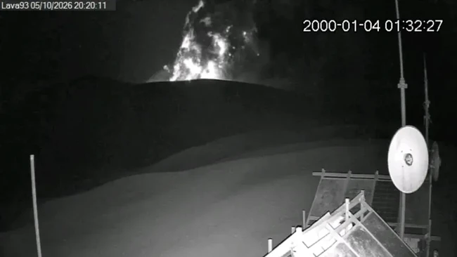
The Geological Agency of the Ministry of Energy and Disurces (ESDM) announced a renewed eruption of Mount Anak Krakatau, Lampung, on Monday (05/10/2026) at 20:13 WIB. However, the height of the ash column was not observed.
“An eruption of Mt. Anak Krakatau, Lampung, occurred on 05 October 2026 at 20:13 WIB, but the height of the ash column was not observed. This eruption was recorded on the seismogram with a maximum amplitude of 55 mm and a duration of approximately 6 minutes and 29 seconds,” stated the Geological Agency’s Threads account on Monday (05/10/2026).
“The eruption was still ongoing at the time this report was being prepared,” the Geological Agency added.
Currently, Mount Anak Krakatau is at Level II (Alert) status, with recommendations that the public, visitors, tourists, and hikers do not approach Mount Anak Krakatau or engage in activities within a 2km radius of the active crater.
As previously noted, on 21 September 2026, the Geological Agency of the Ministry of ESDM lowered the status of Mount Anak Krakatau from Level III (Siaga/Alert) to Level II (Waspada/Caution). This new status has been in effect since Monday, 21 September 2026, at 18:30 WIB.
Mount Anak Krakatau is a Type A active volcano located in the waters of the Sunda Strait, administratively part of the South Lampung Regency, Lampung Province. Nevertheless, observations of Mount Anak Krakatau are conducted through two monitoring posts: the Anak Krakatau Volcano Observation Post in Kalianda, South Lampung, and the Anak Krakatau Volcano Observation Post in Pasauran, Serang Regency, Banten Province.
Based on symptoms of increased volcanic seismicity and deformation, the status of Mount Anak Krakatau was raised to Level III (Alert) on 2 July 2026 at 16:30 WIB. Following increased activity, Mount Anak Krakatau experienced 224 eruptions up until 3 September 2026.
From 4 September 2026 at 23:07 WIB to 6 September 20_04 WIB, continuous eruptions occurred for 25 hours. Based on satellite imagery analysis, these continuous eruptions produced lava flows moving towards the northwest, west, and southwest from the centre of the eruption. Despite experiencing seven Strombolian eruptions after the continuous eruption ceased, the activity of Mount Anak Krakatau tended to decrease until 20 September 2026 at 00:00 WIB.
Seismicity records for Mount Anak Krakatau on 20 September 2026 showed one Low Frequency earthquake and continuous tremors with an average amplitude of 2 mm. Based on comprehensive analysis and evaluation, the activity level of Mount Anak Krakatau was lowered from Level III (Alert) to Level II (Caution) effective from 21 September 2026 at 18:30 WIB.
Source: jawawa.id (https://jawawa.id/newsitem/mount-anak-krakatau-erupts-again-stay-clear-of-2km-radius-1791215560)
Originally published by CNBC Indonesia (https://www.cnbcindonesia.com/news/20261005221652-4-773542/gunung-anak-krakatau-erupsi-lagi-jauhi-radius-2-km), translated from Indonesian