
MJO, Rossby Waves and Slowing Winds: BMKG Issues Latest Warning
Jakarta, CNBC Indonesia — The Meteorology, Climatology and Geophysics Agency (BMKG) says Indonesia’s dry season could last longer because El Niño remains relatively strong, although some areas have already experienced rain.
The agency’s climate monitoring report for early October 2026 showed a sea-surface temperature anomaly in the Niño 3.4 region of +3.33°C and a three-month ENSO index for August–September–October (ASO) of +3.08.
At the same time, the ten-day Indian Ocean Dipole (IOD) index stood at +0.703, relatively close to the monthly index of +0.72 recorded in September.
“These conditions indicate that a very strong El Niño and a positive IOD continue to tend to reduce the potential for rain-cloud formation across Indonesia,” BMKG said in a press release, quoted on Friday (16 October 2026).
The reduced potential for rainfall is consistent with increasingly dry land in a number of areas. This also increases vulnerability to forest and land fires, particularly in regions experiencing long periods without rain.
Monitoring on 14 October 2026 identified 1,297 high-confidence hotspots. The largest concentrations were recorded in Sumatra, with 505, and Kalimantan, with 346, followed by Papua and Maluku, with 330. Sulawesi had 66 hotspots, Nusa Tenggara 38 and Java 12.
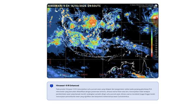
Himawari satellite imagery on 15 October 2026 at 1pm Western Indonesian Time also showed smoke spreading across much of Sumatra, Kalimantan, Sulawesi, Maluku and Papua.
“The distribution of hotspots and smoke shows that the risk of forest and land fires remains a concern, particularly in areas experiencing a rainfall deficit and dry vegetation,” BMKG said.
Amid persistently dry atmospheric conditions, hot temperatures have also become a topic of public concern.
BMKG recorded maximum temperatures above 37°C in some areas on 12–13 October 2026: 38.2°C in Lampung; 37.4°C in South Papua and South Kalimantan; and 37.8°C in West Java and Central Java.
Several factors have contributed to the higher temperatures, including the Sun’s apparent position south of the equator and limited cloud cover.
This allows solar radiation to reach the Earth’s surface at its full intensity, resulting in high air temperatures across much of Indonesia, particularly in the south.
However, BMKG said localised rain remains possible in some areas despite the widespread dry conditions, as atmospheric dynamics may still support the formation of rain clouds capable of producing moderate to heavy downpours.
“Spatial MJO activity, together with Equatorial Rossby Waves, Kelvin Waves and Mixed Rossby-Gravity (MRG) waves, is contributing to increased convective activity, particularly in northern and western Sumatra and parts of Kalimantan,” BMKG said.
The conditions are also supported by slower wind flows in a number of areas and relatively warm sea-surface temperatures in western Indonesian waters, which help supply the moisture needed for rain-cloud formation.
In line with these conditions, BMKG recorded heavy to extreme daily rainfall in several areas between 13 and 15 October 2026: 187mm in Aceh, 63mm in Southwest Papua, 95mm in North Sumatra and 69mm in West Sumatra.
“This shows that the potential for significant rain remains in some parts of Indonesia, even as other areas tend to be dry and have limited cloud cover,” BMKG said.
Weather outlook for the coming week
Around 76% of Indonesia’s seasonal zones (ZOM) are still experiencing the dry season, particularly in Java, Bali, Nusa Tenggara and Sulawesi, while 8% have entered the rainy season.
This could prolong meteorological drought in areas that continue to receive little rain, particularly southern Sumatra, Java, Bali, Nusa Tenggara, parts of Kalimantan and Sulawesi, Maluku, and southern Papua.
Although rainfall is generally forecast to be in the low to moderate category, rain remains possible in several parts of Indonesia.
This is influenced by atmospheric dynamics that can support rain-cloud formation over a relatively short period. Spatial Madden–Julian Oscillation (MJO) activity is forecast to be active in parts of North Kalimantan, West Kalimantan and North Maluku.
BMKG’s weather outlook for Indonesia is as follows:
- 16–18 October 2026
Moderate rain is forecast in Aceh, Riau, the Riau Islands, Bengkulu, West Java, West Kalimantan, Central Kalimantan, East Kalimantan, West Papua, Central Papua and Highland Papua.
Heavy to very heavy rain is forecast in North Sumatra, West Sumatra, the Bangka Belitung Islands, Southwest Papua and Papua.
Rain accompanied by strong winds is possible in Lampung, Banten and West Java.
- 16–18 October 2026
Moderate rain is forecast in North Sumatra, Riau, the Riau Islands, Bengkulu, West Kalimantan, Central Kalimantan, Central Papua and Highland Papua.
Heavy to very heavy rain accompanied by lightning is forecast in Aceh and West Sumatra.
Rain accompanied by strong winds is possible in Bengkulu, Lampung, Banten, West Java and South Papua.
BMKG urged the public to continue taking precautions against hot weather and drier air as the dry season persists.
“Use sunscreen to reduce direct exposure to sunlight. People are also advised to maintain adequate fluid intake, especially when outdoors during the day, to avoid dehydration and exhaustion,” BMKG said.
As dry conditions intensify, residents and local governments are urged to conserve water and remain alert to the threat of drought and forest and land fires.
“BMKG also urges the public not to burn rubbish or clear land carelessly, especially in fire-prone areas such as peatlands, scrub and forests, and to report any suspected fire hotspots immediately,” it added.
In areas at risk of heavy rain, BMKG advised the public and local governments to remain alert to possible flooding, landslides and lightning.