
Magnitude 5.7 Earthquake Strikes Sukabumi, West Java
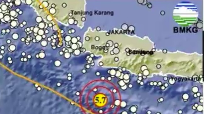
Jakarta, CNBC Indonesia — The Meteorology, Climatology and Geophysics Agency (BMKG) reported a tectonic earthquake in the sea south of Sukabumi, West Java, at 10.30am Western Indonesian Time on Sunday (11 October 2026).
BMKG’s updated analysis put the earthquake at magnitude 5.7, with a hypocentre 10 kilometres deep. Its epicentre was at coordinates 8.87° south and 106.41° east, in the sea about 209 kilometres south-west of Sukabumi Regency, West Java. BMKG’s tsunami modelling found that the earthquake did not have the potential to trigger a tsunami.
Daryono, an earthquake and tsunami expert and member of the Indonesian Association of Disaster Experts (IABI), noted that, from a seismotectonic perspective, the shallow earthquake occurred in the active tectonic region south of Java, where the Indo-Australian Plate converges with the Sunda Plate, part of the Eurasian Plate system.
The plate convergence creates a complex tectonic stress field. As a result, earthquakes occur not only along the plate boundary, or megathrust, but can also take place on fault structures around the subduction system.
Given the epicentre, hypocentre depth and source mechanism, the earthquake indicates shallow submarine faulting south of West Java. Earthquakes of this kind may be associated with deformation within the crust or a plate near the subduction zone.
Analysis of the source mechanism using fault-plane solutions showed that the earthquake was dominated by strike-slip faulting. This demonstrates that earthquakes close to a subduction zone do not always involve thrust faulting.
“Strike-slip mechanisms generally have less capacity to generate tsunamis than thrust faults, which cause significant uplift of the seabed. This is because strike-slip movement is predominantly horizontal, so vertical deformation of the seabed is relatively limited,” Daryono said.
Reports indicated that the earthquake was felt in parts of Sukabumi Regency, including Surade and Tegalbuleud, at intensity III on the Modified Mercalli Intensity (MMI) scale. At this level, shaking is clearly felt indoors and resembles the vibration caused by a heavy vehicle passing.
“The earthquake is also a reminder that the southern coasts of West Java and Banten face a range of earthquake hazards, from local fault activity and intraslab earthquakes to the potential for major earthquakes along the megathrust zone,” Daryono said.
The magnitude 5.7 earthquake should not be interpreted as a sign that a larger earthquake will necessarily occur soon. Nor should it be taken as proof that tectonic energy in the region has been exhausted or that all the potential for a major earthquake has been released.
From a mitigation perspective, the event should provide an impetus to strengthen earthquake and tsunami preparedness among communities on the southern coasts of West Java and Banten. Measures including earthquake-resistant construction, tsunami hazard mapping, evacuation routes and shelters, safety signs, and regular evacuation drills should continue on an ongoing basis.
Coastal residents should understand that if they feel a strong or prolonged earthquake, the safest course is to evacuate immediately to higher ground or move away from the shore, without waiting for a siren or official warning.
“The most important message is that earthquakes cannot yet be predicted precisely, but their risks and impacts can be reduced through science, building engineering, early-warning systems and community preparedness. Not every offshore earthquake causes a tsunami, but everyone living in a tsunami-prone area should know how to protect themselves quickly and independently.
“An earthquake need not become a major disaster if people understand the threat, recognise the warning signs and know what action to take to save themselves.”