
Magnitude 4.8 earthquake hits Jember, felt in Bali's Kuta
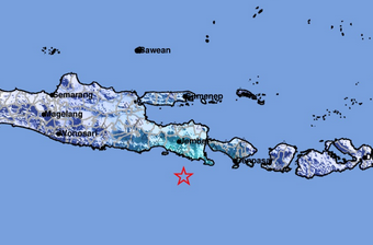
Southeast Jember, East Java, was struck by a tectonic earthquake on Tuesday (26/5) at 15:39:10 WIB. The Meteorology, Climatology, and Geophysics Agency (BMKG) reported that the quake does not pose a tsunami risk. Initial analysis indicated a magnitude 5.1 earthquake, later revised by BMKG to 4.8. The epicentre was located at 9.07°S and 113.82°E, 99 km southeast of Jember in the sea, at a shallow depth of 14 km. BMKG’s Earthquake and Tsunami Director, Dr. Wijayanto, S.T., M.Sc., explained that based on the epicentre location and hypocentre depth, the quake was a shallow event caused by rock deformation within the tectonic plate (intraplate earthquake). The quake was felt across various areas with differing intensities. Widi, 53, a resident of Dalung Permai in North Kuta, said, ‘I felt a slight vibration while sitting relaxed earlier.’ As of 15:55 WIB, BMKG monitoring showed no aftershocks. Residents are advised to remain calm and avoid damaged or cracked buildings. BMKG confirmed the quake poses no tsunami risk. The public is urged to rely only on verified official information from BMKG’s communication channels. (RS/I-1)