
M7.7 Earthquake Shakes NTT: Why Eastern Indonesia Is Prone to Major Disasters
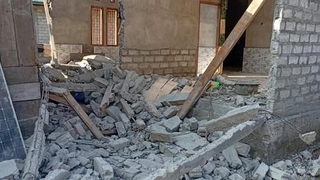
A magnitude 7.7 earthquake shook the East Nusa Tenggara (NTT) region on Saturday morning (15/8/2026). The quake briefly triggered a tsunami early warning.
Director of Earthquakes and Tsunamis at BMKG Wijayanto said the earthquake was caused by the North Flores Back Arc Thrust fault.
“This earthquake occurred due to the North Flores Back Arc Thrust fault. A M7.7 earthquake has a maximum potential of M7.8-7.9. An earthquake of this size last occurred in 1992, with a magnitude of M7.5,” Wijayanto said in a BMKG press conference via Zoom on Saturday (15/8/2026).
This morning’s NTT earthquake adds to the long seismic history of Eastern Indonesia, which is known as one of the regions with the highest tectonic activity in the world.
So why does this happen in Eastern Indonesia?
According to research by the University of Muhammadiyah Mataram titled “Interaction of Three Plates in the Eastern Indonesia Region” (2025), the geological conditions of Eastern Indonesia are highly complex because the region is an interaction zone for three major plates: the Indo-Australian, Eurasian and Pacific plates.
The three plates interact around the Banda Sea, Maluku Sea and Seram region. Their movement forms various geological structures, ranging from subduction zones and active faults to back-arc basins.
The plate movement is also continuous. The research notes that the Indo-Australian Plate moves relatively northward at about 7 centimetres per year, while the Pacific Plate moves westward at up to about 10 centimetres per year. This movement causes the Earth’s crust to deform and increases seismic activity in the region.
“As a result, this region has a very high frequency of seismic and volcanic activity, as well as land and seabed morphology that continuously changes due to geodynamic pressure,” the research states.
The situation is further complicated because the three plates do not produce just one type of movement. Various types of movement, such as compression, extension and shear forces, can occur simultaneously in different areas. This makes Eastern Indonesia one of the most geotectonically active regions in the world, alongside Japan and Chile.
“The Eastern Indonesia region is known as one of the world’s highest centres of seismic and volcanic activity,” the research team said.
As a result, the region is frequently struck by earthquakes of varying magnitudes. The tectonic activity is also linked to volcanic activity and changes in land and seabed formations.
In the modern era, one of the major events occurred on 12 December 1992, when the Flores earthquake shook NTT with a magnitude of M7.8 and triggered a 25-metre tsunami that struck several coastal areas. The disaster claimed 2,500 lives and led the government to declare it a national disaster.
Much earlier, the Ambon and Banda Sea regions also experienced major earthquakes followed by tsunamis. The most devastating occurred in Banda in 1629, when a tsunami tens of metres high flattened the area.
History shows that major earthquakes in Eastern Indonesia are not a new phenomenon. The region’s geological conditions mean tectonic activity continues unabated. Therefore, understanding and preparedness for disaster mitigation must continue to be instilled in the public and all relevant stakeholders.