
M 6.4 Earthquake in Simalungun, North Sumatra Felt as Far as Medan
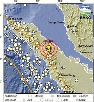
A tectonic earthquake measuring magnitude 6.4 shook Simalungun Regency, North Sumatra, on Saturday (15/8) afternoon. Moderate to strong tremors were felt by residents in several cities, including Medan and Pematangsiantar.
Analysis by the Meteorology, Climatology and Geophysics Agency (BMKG) showed the earthquake occurred at 5.54 p.m. Western Indonesia Time. The epicentre was located at coordinates 2.91° North latitude and 98.93° East longitude.
The earthquake source was on land, 11 kilometres southeast of Simalungun, at a depth of 168 kilometres.
“Taking into account the epicentre location and hypocentre depth, the earthquake was an intermediate-depth earthquake caused by plate subduction activity,” said BMKG Director of Earthquakes and Tsunamis Wijayanto on Saturday (15/8).
Wijayanto explained that source mechanism analysis showed the earthquake had an oblique normal fault mechanism. BMKG modelling confirmed the earthquake had no tsunami potential.
Based on shakemap estimates, shaking intensity reached V on the Modified Mercalli Intensity (MMI) scale in Tebingtinggi City, Kabanjahe District (Karo Regency) and Limapuluh City (Batubara Regency).
“The shaking was felt by nearly all residents, waking many people up,” Wijayanto said.
Shaking of IV MMI was felt by residents in the Raya, Panombeian Pane, Panei, Pematangsiantar City and Pangururan areas, and was also felt as far as Medan City.
As of 6.16 p.m. Western Indonesia Time, BMKG monitoring had not shown any aftershock activity. BMKG therefore urged the public to remain calm and not be easily influenced by unverified information.
Nevertheless, BMKG still advised residents to avoid cracked or damaged buildings.