
Latest Facts on the M6.7 Palu Earthquake: Beware of Liquefaction and Ground Cracks
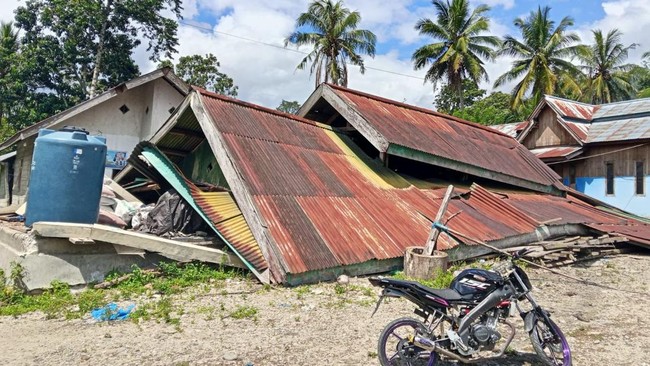
The Geological Agency of the Ministry of Energy and Mineral Resources (ESDM) has mapped the potential for secondary hazards such as ground cracks and liquefaction following the Magnitude 6.7 earthquake in Central Sulawesi. The mapping is based on subsurface geophysical analysis that identified intensive activity on the Palolo Graben structure.
The agency explained that the tremor, centred 42 kilometres southeast of Palu City, had a normal fault mechanism. Field teams are closely monitoring the distribution of more than 150 aftershocks recorded with varying magnitudes between 2.5 and 5.1 up to 18 June 2026.
“The occurrence of the main earthquake followed by numerous aftershocks indicates complex geological conditions, with diverse lithology types in terms of rigidity and hardness, as well as intensively developed geological structures in the affected area,” the Geological Agency stated.
“The earthquake may be followed by secondary hazards such as ground cracks, land subsidence, landslides, and liquefaction. The public is urged to remain alert and avoid cliff areas that are prone to landslides,” the agency stressed.
According to the agency’s data, there are differences in the earthquake’s strength parameters from various international institutions, with the USGS recording Magnitude 6.99 at a depth of 11.5 km, while GFZ reported Magnitude 6.66 at a depth of 10 km. Nevertheless, the ground shaking was felt very strongly, reaching intensity IX MMI, triggered by soft soil conditions in residential areas.
“Analysis shows a normal fault mechanism triggered by the Palolo Fault (graben), not the Palu-Koro or Sausu faults which have strike-slip mechanisms. We also found no indication that the Palu-Koro Fault was activated by this earthquake,” the agency continued.
It was emphasised that the rise in sea water followed by a receding wave was not due to a tsunami, but rather the effect of physical changes to the coastline caused by the strong shaking, including land subsidence. “It was not an indication of a tsunami,” the agency stated.
Physical impacts in the field show land subsidence that caused sea water in Palu Bay to temporarily recede after the tremor. In addition, slope instability on Mount Kamarora triggered landslides and subsidence on the access road to the Napu area.
The affected area, classified as having medium to high disaster risk, has soil classifications ranging from soft rock to very soft soil (Vs30 classes C, D, and E). This condition triggers the potential for liquefaction in Sigi Regency, Palu City, Parigi Moutong Regency, and parts of Poso Regency.
The Geological Agency recommends that all buildings in vulnerable areas be designed according to earthquake-resistant standards and equipped with adequate evacuation routes.
The public is also urged to always check the structural condition of buildings to ensure safety before resuming activities indoors, to avoid the risk of being struck by debris from aftershocks.
Regarding the potential for liquefaction, which is also influenced by the level of shaking and soil type, the Geological Agency stressed it will continue to conduct strict field monitoring.
“Always follow the directions and information from local BPBD officials, and remain alert to the possibility of aftershocks. Do not be influenced by irresponsible information regarding earthquakes or tsunamis,” the agency stated.
“Stay calm, do not panic, but remain vigilant. Because aftershocks are normal, avoid cracked buildings. Do not easily believe rumours or hoaxes, and always refer to official information from BPBD, BNPB, and the local government,” the agency concluded.