
Jakarta and Java on Megathrust-Tsunami Alert? BMKG and Experts Explain
A man known online as an amateur meteorology expert has claimed that a powerful earthquake will strike Indonesia before the end of 2026, with a potential magnitude of M7.0-9.0.
In a broadcast on his YouTube channel, the Canadian, named Frankie MacDonald, warned that residents of Indonesia in Java and Jakarta must prepare for a major earthquake that would trigger massive damage.
MacDonald’s “prediction” promptly sparked a stir, particularly as it was linked to earthquakes that have occurred in Indonesia and which he had previously mentioned.
When MacDonald specifically warned Java and Jakarta, attention turned to the megathrust potential surrounding Java, including Jakarta.
What is the connection?
As is known, the Meteorology, Climatology and Geophysics Agency (BMKG) and experts have repeatedly highlighted the megathrust potential located along the western coast of Sumatra and in the Sunda Strait.
For information, the 2024 Indonesian Earthquake Source and Hazard Map records 14 megathrust zones spread across Indonesia:
The Aceh-Andaman Megathrust Zone could produce an earthquake with a maximum magnitude of 9.2
The Nias-Simeulue Megathrust Zone could produce an earthquake with a maximum magnitude of 8.7
The Batu Megathrust Zone could produce an earthquake with a maximum magnitude of 7.8
The Mentawai-Siberut Megathrust Zone could produce an earthquake with a maximum magnitude of 8.9
The Mentawai-Pagai Megathrust Zone could produce an earthquake with a maximum magnitude of 8.9
The Enggano Megathrust Zone could produce an earthquake with a maximum magnitude of 8.9
The Java Megathrust Zone could produce an earthquake with a maximum magnitude of 9.1
The West Java Megathrust Zone could produce an earthquake with a maximum magnitude of 8.9
The East Java Megathrust Zone could produce an earthquake with a maximum magnitude of 8.9
The Sumba Megathrust Zone could produce an earthquake with a maximum magnitude of 8.9
The North Sulawesi Megathrust Zone could produce an earthquake with a maximum magnitude of 8.5
The Cotabato Trench Megathrust Zone could produce an earthquake with a maximum magnitude of 8.3
The Southern Philippines Megathrust Zone could produce an earthquake with a maximum magnitude of 8.2
The Central Philippines Megathrust Zone could produce an earthquake with a maximum magnitude of 8.1
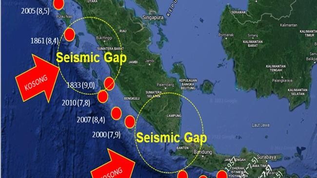
The Sunda Strait and Mentawai-Siberut Megathrust Zones have drawn attention because both segments are said to have not released their energy for hundreds of years. This condition is known as a seismic gap. As a result, preparedness has emerged: a megathrust event from these two segments is considered a matter of time, though when it will occur cannot be predicted.
“A seismic gap is an active earthquake source zone where no major earthquake has occurred in the last tens to hundreds of years. It is believed to be in the process of accumulating seismic energy,” said Daryono, a member of the Indonesian Disaster Expert Association (IABI), speaking to CNBC Indonesia on Tuesday (8/9/2026).
“The southern Banten and Sunda Strait regions have experienced a major earthquake gap (seismic gap) since 1757 (269 years). Meanwhile, the Mentawai and Siberut regions have experienced a major earthquake gap since 1797 (229 years),” he added.
According to Daryono, the Sunda Strait megathrust zone has the greatest potential to affect the Jakarta-West Java region.
So, could this megathrust trigger a tsunami?
A tsunami triggered by a megathrust earthquake depends on the strength and conditions at the time the quake occurs.
In model calculations, the tsunami potential caused by this megathrust could generate waves above 3 metres. This is the wave height when the tsunami reaches the beach or coast.
“If the coastline is shallow, the tsunami can be high. It could be 4 metres, 5 metres, even 20 metres. A 3-metre wave is the first effect after the earthquake occurs. This is based on modelling,” Daryono explained.
BMKG’s explanation
Separately, the Director of Earthquakes and Tsunamis at BMKG, Wijayanto, emphasised that the agency continuously monitors seismic activity potential across Indonesia, not focusing on any particular segment or zone.
“All segments are a priority for BMKG. BMKG monitors seismic activity across Indonesia 24/7, whether from megathrust sources or active faults,” said Wijayanto.
“The Sunda Strait segment could potentially impact the Jakarta region. We have already socialised and coordinated this several times with regional governments and relevant agencies,” he added.
Wijayanto referred to the 2024 National Earthquake Study Centre (Pusgen) findings, which state that the Sunda Strait or West Java segment could produce an earthquake with a maximum magnitude of M8.9.
“It could potentially be felt in Jakarta with an intensity of V-VI MMI. A minor tsunami with alert status (less than 0.5 metres) would reach the northern Jakarta coast around 3 hours after the earthquake,” Wijayanto explained.
Indonesia is earthquake-prone, but stay calm
On the other hand, Wijayanto emphasised that Indonesia is indeed located in an earthquake-prone region.
“We have socialised this many times. There are threats from megathrust sources and active faults. But when and where exactly cannot be determined. There is no technology yet that can predict earthquakes precisely in terms of time and location,” said Wijayanto.
“Indonesia is an earthquake-prone region. Earthquakes can happen at any time; when and where they will occur cannot yet be predicted precisely,” he stressed.
Therefore, he urged Indonesians to remain vigilant but calm.
“The Indonesian public is urged to remain calm and vigilant, and not to be influenced by unverified information, particularly that circulating on social media,” he said.
“Mitigation steps that can be taken include knowledge of how to survive, evacuation procedures, building reinforcement, strengthening evacuation signage, and so on. Official information regarding tsunami early warnings comes only from BMKG, through its channels [website bmkg.go.id, the infoBMKG application, and @infoBMKG],” Wijayanto affirmed.