
Indonesia's Updated Megathrust Map Now Identifies 14 High-Risk Zones
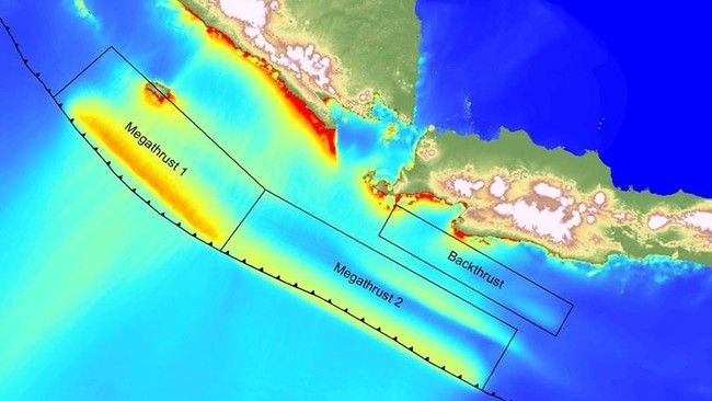
Jakarta, CNBC Indonesia — The risk of a major earthquake in Indonesia has returned to public attention after the updated 2024 Indonesia Earthquake Source and Hazard Map showed an increase in the number of megathrust zones. The latest map now contains 14 megathrust zones, up from the 13 listed in the 2017 edition.
The update indicates a higher level of seismic hazard in a number of regions. One of the main highlights is the denser earthquake hazard contours on the latest map, reflecting a greater potential threat compared with previous mapping.
Iswandi Imran, a member of the Indonesian Academy of Sciences (AIPI) and a professor at the Bandung Institute of Technology (ITB), said the change signals that several regions in Indonesia face a higher earthquake risk.
“Between the 2017 and 2024 maps, if we look at the denser contours in the 2024 edition, that indicates an increase in earthquake hazard in certain areas of Indonesia,” said Iswandi.
The 2024 map also records the potential for very large earthquakes in several zones. The Java Megathrust Zone, for instance, has the potential for a quake of up to magnitude 9.1, while several other zones such as Enggano and Mentawai-Pagai could trigger earthquakes of up to 8.9.
The following are the 14 megathrust zones in the 2024 Indonesia Earthquake Source and Hazard Map, along with their maximum potential magnitudes:
Aceh-Andaman (magnitude 9.2)
Nias-Simeulue (8.7)
Batu (7.8)
Mentawai-Siberut (8.9)
Mentawai-Pagai (8.9)
Enggano (8.9)
Java (9.1)
West Java (8.9)
East Java (8.9)
Sumba (8.9)
North Sulawesi (8.5)
Cotobato Trench (8.3)
Southern Philippines (8.2)
Central Philippines (8.1)
Previously, the Meteorology, Climatology and Geophysics Agency (BMKG) said there are two megathrust zones currently “just waiting for the right time” to release their energy: the Sunda Strait Megathrust, which last ruptured in 1757, and Mentawai-Siberut in 1797.
BMKG explained that this condition is known as a seismic gap — a region that geologically stores large amounts of energy because it has not experienced a major earthquake for a long time.
“‘Just waiting for time’ is not a prediction. That phrase is often misunderstood. What it means is that the zone holds great potential because it has long gone without releasing energy. It does not mean an earthquake will occur in the near future,” BMKG wrote on its official Instagram account.
BMKG stressed that the term is used as a form of vigilance based on historical and geological data, not to incite public panic.
“This scientific term is used as a form of preparedness based on historical and geological data, not to cause panic. Under Law No. 31/2009, BMKG is responsible for observation, data management and information services, including for earthquakes and tsunamis,” BMKG explained.